

You are here
Avalanche Advisory for 2013-03-30 06:51:11
- EXPIRED ON March 31, 2013 @ 6:51 amPublished on March 30, 2013 @ 6:51 am
- Issued by Nick Meyers - Shasta-Trinity National Forest
Bottom Line
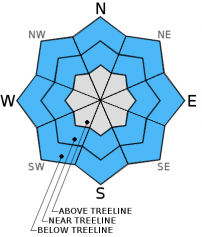
The avalanche danger today is low for all aspects and elevations. We currently sit in the calm before the storm... Significant precipitation in the form of rain and snow will develop over the forecast area later today, tonight and Sunday. Elevations below 10,000 feet will see mostly rain on snow. On the upper mountain, one to two feet of new snow is possible. Avalanche conditions are currently low this morning but are expected to rise as the storm moves through. Any instability due to rain will likely be seen within the first few hours of precip. Storm slab and wind slabs will be most suspect on Sunday. Climbers should use extra caution this weekend and be sure to carry a beacon, shovel and probe!


Avalanche Problem 1: Wet Slab
-
Character ?

-
Aspect/Elevation ?
-
Likelihood ?CertainVery LikelyLikelyPossible
 Unlikely
 -
Size ?HistoricVery LargeLargeSmall

Wet-Loose avalanches will be possible today and with the greatest chance during the first few hours of precipitation that arrives. Our main concern for wet-loose slides will lie in the top layers of snow, mainly the 2"-4" inches we received this past week. Wet Loose slides involve the release of wet, unconsolidated snow or slush. These slides typically occur within layers of wet snow near the surface of the snowpack, though can gouge into lower snowpack layers. They usually start at a point and entrain more snow as they move downhill, forming a fan-shaped avalanche. Wet loose slides generally move slowly, but can contain enough mass to easily cause damage to trees, etc., not to meniton human life and limbs.
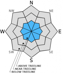
Avalanche Problem 2: Storm Slab
-
Character ?

-
Aspect/Elevation ?
-
Likelihood ?CertainVery LikelyLikelyPossible
Unlikely
-
Size ?HistoricVery LargeLargeSmall
For upper elevations, above 10,000 feet, new snow accumulation with the incoming storm could be upward of one to two feet. The chance for storm slab avalanches will increase as new snow accumulates. Sunday will likely host the greatest chance for storm slab avalanches, but worth a mention today as precip begins to fall this afternoon.
Avalanche Problem 3: Wind Slab
-
Character ?

-
Aspect/Elevation ?

-
Likelihood ?CertainVery LikelyLikelyPossible
Unlikely
-
Size ?HistoricVery LargeLargeSmall
Wind slab formation will be likely in the afternoon today, tonight and Sunday. Winds do not look strong with this storm, but could be just the right speed to move snow onto leeward slopes. Often high winds are present on the upper mountain and usually blow snow available for transport away. However, with this storm, wind speeds look moderate and we could see wind loading in isolated areas around chutes, gullies, rock outcrops, etc.
Recent Observations
Good skiing conditions were found yesterday with a couple inches of new snow that fell this past Tuesday/Wednesday. New snow was very wet below treeline. North and northwest aspects above treeline have held the new snow fairly well, while southerly aspects the snow has settled into our isothermic snowpack. Firm snow and a stable snowpack exists overall. The Castle Lake area snow coverage is getting thin and most folks are not venturing onto the lake due to soft edges.
As spring approaches and temperatures begin to warm, spring skiers and climbers should keep WET-LOOSE AVALANCHES in mind. Sunny days and spring time can cause folks to forget their "avalanche awareness". Loose-wet slides occur every year on Mt. Shasta and can be very large and harmful to human life!
Significant rain can also cause WET-LOOSE AVALANCHES. Use caution this weekend.
This is a great video from the Gallatin Avalanche Center, Bozeman, MT demonstrating small loose-wet slides: http://www.youtube.com/watch?v=zWpRQzgtL3o&feature=share&list=PLXu5151nmAvT7gHqdNajDBGfGY4u5XMSL
Weather and Current Conditions
Weather Summary
This morning the low pressure system we mentioned yesterday is set up off shore and ready to send us a deluge of precipitation beginning this afternoon. Unfortunately, this storm will start with snow levels upwards of 9,000 to 10,000 feet and lowering by Sunday...however most of the precip will have already fallen by the time temps cool. So, with this storm, "miracle march" will apply much better to river rats than skiers! Precipitation amounts have risen a bit, although a few models are hosting different results...overall it looks like .5" to .83" of water should fall by Monday morning. The bulk of the rain and/or high elevation snow will fall late Saturday night and Sunday morning. For upper elevations receiving snow, we could see upwards of a foot of the fresh white. Winds look to be light to moderate below and above treeline. Climbers planning on attempting Mt. Shasta this weekend should be prepared for full winter / very wet conditions.
WEATHER STATIONS - (last 24 hours):
In Mt. Shasta City at 0500, we have cloudy skies and with and a current temperature of 36 F.
On Mt. Shasta: In the Old Ski Bowl (7,600') on the south side of Mt. Shasta, we have a current temperature of 39F. Snow on the ground totals 105" inches with 1" of settlement. Temperatures have ranged from 30 F to 52 F. At Grey Butte (8,000') on the south side of Mt. Shasta winds averaged 12 mph from various directions with a few gusts to 28 mph from the east. The current temperature is 40F and temps have ranged 26F to 45F.
Castle/Mt. Eddy: Castle Lake - Castle Lake is hosting a current temp of 44F. Temperatures have ranged from 34F to 58F. Snow depth measures 38" inches with 1" settlement.. On Mt Eddy, we have 58" inches of snow on the ground. The current temperature reads 40F with temps ranging from 31F to 50F. Winds have been averaging 2 mph from the SW and gusting to 11 mph - ESE.
THIS SEASON: September and October were warm and dry with September recording exactly zero precipitation. November remained warmer than normal with precipitation almost double normal values, 9.16" vs. 5.08". A local weather COOP observed the 2nd wettest November on record. December started out wet and warm, but temperatures cooled and brought snow to very low elevations. Since our avalanche cycle near Christmas, we've had a few small storms that brought some amounts of snow to the area, but did not produced any notable avalanches. January was below normal for precipitation with a long period of high pressure and sun that kept skiing conditions somewhat meager. We've had a few storms for 2013 that have brought us glimpses of wintery weather, but nothing to write home about! California and the Sierra Nevada have recorded the driest January and February on record. We currently have 4.5'-8.5' feet of snow above 6,500 ft. Since September 1st, Mt Shasta sits at 69% of normal, 24.93" recorded; normal 35.87". For 2013, we sit at 21% of normal with 4.23" recorded and 19.99" normal.
| 0600 temperature: | 31 |
| Max. temperature in the last 24 hours: | 36 |
| Average wind direction during the last 24 hours: | Various |
| Average wind speed during the last 24 hours: | 10 mi/hr |
| Maximum wind gust in the last 24 hours: | 21 mi/hr |
| New snowfall in the last 24 hours: | 0 inches |
| Total snow depth: | 58-106 inches |
Two Day Mountain Weather Forecast
Produced in partnership with the Medford NWS
| For 7000 ft to 9000 ft | |||
|---|---|---|---|
|
Saturday (4 a.m. to 10 p.m.) |
Saturday Night (10 p.m. to 4 a.m.) |
Sunday (4 a.m. to 10 p.m.) |
|
| Weather | Mostly cloudy, rain showers and slight chance of thunderstorms this afternoon. | Rain showers and chance of thunderstorms. Rain showers after midnight | Rain, rain and snow in the afternoon. Little snow accumulation |
| Temperature (°F) | Mid 50's to lower 60's | Mid 30's | Mid 40's to lower 50's |
| Wind (mi/hr) | East, Southeast 5-10 mph | Southwest to southeast 5-10 mph | Southeast 5-10 mph |
| Precipitation SWE / Snowfall (in) | / 0 | / 0 | / 0 |
| For 9000 ft to 11000 ft | |||
| Saturday | Saturday Night | Sunday | |
| Weather | Rain and snow in the afternoon, breezy | Rain and snow showers, windy | Rain and snow |
| Temperature (°F) | 39 | 22 | 25 |
| Wind (mi/hr) | Southeast light to moderate, 10-20 mph | East to Southwest 1-2 | Southwest 10-20 mph with gusts higher |
| Precipitation SWE / Snowfall (in) | / 1-2 | / 6-10 | / 3-7 |

