

You are here
Avalanche Advisory for 2013-04-06 06:44:23
- EXPIRED ON April 7, 2013 @ 6:44 amPublished on April 6, 2013 @ 6:44 am
- Issued by Nick Meyers - Shasta-Trinity National Forest
Bottom Line
A low chance of human triggered wind slabs exists today. Very isolated wind slabs will exist near and above treeline. Mid-elevation, S, SE, E, NE aspects and complex/extreme terrain will be the best place to find these slabs. Periods of recent snowfall with moderate to high west winds on the mountain have created these slabs. On the upper mountain, it's likely most of the snow has blown away and the snowpack has been scoured down to firm, icy snow. Slabs could be 6-12 inches deep.Cooling temperatures and increased cloud cover has decreased the chance of any loose-wet avalanches today . Further cooling will occur for the rest of the weekend and will help refreeze our current snowpack. Any warming related instabilities will be limited to roller balls, pin wheels and small, isolated point releases. If and when temperatures do begin to warm in the future, loose-wet instabilities will become a concern again.


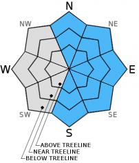
Avalanche Problem 1: Wind Slab
-
Character ?

-
Aspect/Elevation ?
-
Likelihood ?CertainVery LikelyLikelyPossible
 Unlikely
 -
Size ?HistoricVery LargeLargeSmall

Westerly winds yesterday were a constant source of snow transport on ridge lines and on the upper mountain. While most of the snow appeared to be blowing away, one should not be surprised to find areas of wind loading on leeward S, SE, E, NE aspects. Chutes, gullies, rock outcrops, and orographic wind eddies could host small wind slabs up to 1 foot thick.
Winds averaged 15mph consistently for the past 24 hours with gusts into the mid to high 20's at 8,000 feet on Gray Butte. It looks to be another breezy day today, westerly, averaging 40-50mph on the upper mountain. Again, while much of the snow is simply blowing away, there could easily be areas of wind loading on the leeward aspects mentioned above.
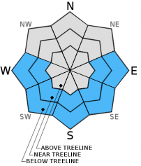
Avalanche Problem 2: Loose Wet
-
Character ?

-
Aspect/Elevation ?
-
Likelihood ?CertainVery LikelyLikelyPossible
Unlikely
-
Size ?HistoricVery LargeLargeSmall
Loose-wet avalanches will be unlikely today. One may find pinwheels or a few roller balls out there, but with cooler temps over the past few days, loose-wet avalanches will be difficult to trigger.
Loose-wet slides involve the release of wet, unconsolidated snow or slush. These slides typically occur within layers of wet snow near the surface of the snowpack, though can gouge into lower snowpack layers. They usually start at a point and entrain more snow as they move downhill, forming a fan-shaped avalanche. Loose-wet slides generally move slowly, but can contain enough mass to easily cause damage to trees, etc., not to meniton human life and limbs.
Recent Observations
Yesterday was sunny, though wind and cooler temps kept any loose-wet snow instabilities to a minimum. Wind was the main event for the day. Lower elevations in Avalanche Gulch did not see much wind at all, however ridge lines and the upper mountain received strong westerly winds for the majority of the day. Winds were strong enough to scour most of the upper elevation snowpack down to old firm snow, though I wouldn't be surprised if a few areas hosted some small, fresh wind slabs. No wind slabs to our knowledge were triggered yesterday.
This past week we saw a number of loose-wet snow instabilities, however colder temperatures have helped freeze the snowpack at night and chance of any loose-wet slides will be low today. No recent avalanche activity has been reported.
Worth mentioning however, two medium to large loose-wet sloughs were witnessed off the east aspect of Casaval Ridge that ran all the way down into Avalanche Gulch and were visible from town. These were skier triggered slides and entrained a good bit of snow as they moved down the slope at a pretty good clip. Debris was several feet high. When temps warm and things get greasy, loose-wet slides should not be taken lightly on large, unobstructed slopes that Mt. Shasta hosts!
Skiing conditions yesterday were outstanding and the visibility was good. The snowpack was supportable with a few inches of packed powder on top. One to six inches of new snow was present on most aspects, though east facing aspects seemed to hold the most new snow due to the westerly flow in the recent days. In some drifted areas at mid and upper elevations, up to a foot of new snow was reported with smooth and supportable riding conditions. Above Lake Helen, gullies hosted some good skiing, though most was firm and somewhat icy and scoured due to winds.
Castle Lake skiing is pretty much done for the season. One could still ski in the area, but shallow snow with manzanita and rock slalom will be the soup de jour. Be careful of the lake edges. Soft icy and snow exists and it's easy to fall in this time of year.
A note on spring conditions:
As spring approaches and temperatures begin to warm, spring skiers and climbers should keep LOOSE-WET AVALANCHES in mind as you climb. Sunny days and spring time can cause folks to forget their "avalanche awareness". Loose-wet slides occur every year on Mt. Shasta and can be large and hazerdous! Even though the avalanche danger may be low, this means that avalanches are still possible. A BEACON, SHOVEL & PROBE are STILL A GREAT IDEA for the coming spring months!
Pay attention to who is above you when climbing, and be aware of who is below you when skiing or decending!
Weather and Current Conditions
Weather Summary
Cool and wet conditions will prevail for the rest of the weekend. A low pressure system hits land this morning and should bring some rain and a brief cold snap to the area. Rain and snow will fall with snow levels expected near 5,500 feet today and falling to town or lower by tomorrow. Windy conditions will accompany this low pressure, westerly in nature today and will switch to north/northwest Monday. Precipitation amounts are forecasted to be upwards of a half inch of water. High pressure will build and the short lived cold air will leave the area Tuesday. Later next week, we will see a slight cooling trend with a chance of more precip.
WEATHER STATIONS - (last 24 hours):
In Mt. Shasta City at 0500, we have cloudy skies and a current temperature of 44 F.
On Mt. Shasta: In the Old Ski Bowl (7,600') on the south side of Mt. Shasta, we have a current temperature of 30F. Snow on the ground totals 107" inches with 2" of new snow and little settlement. Temperatures have ranged from 27 F to 33 F. At Grey Butte (8,000') on the south side of Mt. Shasta winds have been westerly averaging 15mph with a couple gusts to 28 mph from the WSW and WNW. The current temperature is 28F and temps have ranged 27F to 33F.
Castle/Mt. Eddy: Castle Lake - Castle Lake is hosting a current temp of 33F. Temperatures have ranged from 33F to 50F. Snow depth measures 24" inches with 2" inches settlement. (Castle Lake snow depth sensor is giving occasional error readings due to low snow.) On Mt Eddy, we have 54" inches of snow on the ground with 3" new snow and little settlement. The current temperature reads 34F with temps ranging from 30F to 39F. Winds have been averaging 2 mph / SE and gusting to 14 mph - SE
THIS SEASON: September and October were warm and dry with September recording exactly zero precipitation. November remained warmer than normal with precipitation almost double normal values, 9.16" vs. 5.08". A local weather COOP observed the 2nd wettest November on record. December started out wet and warm, but temperatures cooled and brought snow to very low elevations. Since our avalanche cycle near Christmas, we've had a few small storms that brought some small amounts of snow to the area, but did not produced any notable avalanches. January was below normal for precipitation with a long period of high pressure and sun that kept skiing conditions somewhat meager. We've had a few storms for 2013 that have brought us glimpses of wintery weather, but nothing to write home about! California and the Sierra Nevada have recorded the driest January and February on record. We currently have 4.5'-8.5' feet of snow above 6,500 ft. Since September 1st, Mt Shasta sits at 70% of normal, 26.00" recorded; normal 36.83". For 2013, we sit at 25% of normal with 5.30" recorded and 20.95" normal.
| 0600 temperature: | 33 |
| Max. temperature in the last 24 hours: | 36 |
| Average wind direction during the last 24 hours: | WEST/SOUTHWEST |
| Average wind speed during the last 24 hours: | 15 mi/hr |
| Maximum wind gust in the last 24 hours: | 28 mi/hr |
| New snowfall in the last 24 hours: | 1-3 inches |
| Total snow depth: | 53-105 inches |
Two Day Mountain Weather Forecast
Produced in partnership with the Medford NWS
| For 7000 ft to 9000 ft | |||
|---|---|---|---|
|
Saturday (4 a.m. to 10 p.m.) |
Saturday Night (10 p.m. to 4 a.m.) |
Sunday (4 a.m. to 10 p.m.) |
|
| Weather | RAIN AND SNOW SHOWERS, SNOW LEVEL NEAR 5,500 FEET, TEMPS DROPPING AS COLD FRONT MOVES IN. | SNOW SHOWERS LIKELY AND CHANCE OF THUNDERSTORMS. SNOW LEVEL NEAR 3,500 FEET. COOLING. | MOSTLY CLOUDY WITH A SLIGHT CHANCE (30%) OF SNOW SHOWERS. SNOW LEVEL TO TOWN OR LOWER. COLD, THEN WARMING INTO TUESDAY |
| Temperature (°F) | 36 | 17 | 38 |
| Wind (mi/hr) | SOUTH/SOUTHWEST 20-30MPH | SOUTH/SOUTHWEST SWITCHING TO NORTHWEST 15-25MPH | NORTHWEST 20-25MPH |
| Precipitation SWE / Snowfall (in) | / 1-3 | / 3-5 | / 0-.5 |
| For 9000 ft to 11000 ft | |||
| Saturday | Saturday Night | Sunday | |
| Weather | SNOW SHOWERS | SNOW LIKELY , MOSTLY CLOUDY | PARTLY SUNNY, CLEARING AND WARMING INTO TUESDAY |
| Temperature (°F) | 21 | 5 | 23 |
| Wind (mi/hr) | WEST/SOUTHWEST 60-70MPH WITH GUSTS HIGHER | WEST. BECOMING NORTHWEST IN THE EVENING 3-5 | NORTHWEST 40-50 MPH FROM THE NORTHWEST, INCREASING TO 50-60MPH IN THE MORNING. |
| Precipitation SWE / Snowfall (in) | / 3-5 | / 5-9 | / 0-.5 |

