

You are here
Avalanche Advisory for 2013-12-08 06:59:17
- EXPIRED ON December 9, 2013 @ 6:59 amPublished on December 8, 2013 @ 6:59 am
- Issued by -
Bottom Line
Three to seven inches of snow covers the slopes of our forecast area. We currently are patiently... I mean chomping at the bit, for more snow to fall. It will take likely 12 inches or more of snow to allow for snow sports to commence!
The only skiing and chance of avalanche danger will be on Mt. Shasta's glaciers. This danger remains low and it's likely that most of the cold, light density snow has blow away from the upper elevation winds we've received.


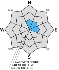
Avalanche Problem 1: Normal Caution
-
Character ?

-
Aspect/Elevation ?
-
Likelihood ?CertainVery LikelyLikelyPossible
 Unlikely
 -
Size ?HistoricVery LargeLargeSmall

Skiing on Mt. Shasta's glaciers at this time is rough, icy and topped with a light dusting of new snow. It's unlikely that any avalanche activity would occur since stiff northerly winds have probably blown much of the new snow away. Any skiing on the glaciers would be above 10,000 feet and not for the faint of heart!
Recent Observations
A stiff glass of snow on the rocks is currently what the greater Mt. Shasta area is serving today. It will take a delivery of more snow for snow sports to become the soup de jour. One should monitor our early season menu of snow layers. As more snow is delivered, these layers will dictate the avalanche danger daily special in the weeks to come.
Terrain: Remember most of the terrain that we like to play on is greater than 30 degrees. Avalanches are possible on anything steeper than 30 degrees. Avoid cornices, rock bands, terrain traps and runout zones of avalanche paths.
Weather: Most of our areas avalanche danger will occur 24-48 hours after a storm. We still can see persistent weak layers from time to time and we always will be sure to let you know about that! Heed the basic signs: Wind (significant snow transport and depositions), Temperature (rain/snow/rain/snow, which in turn weakens the snowpack), and Precipitation (Snow or rain add weight and stress to the current snowpack).
Snowpack: If snow accumulates, give the snowpack a chance to adjust to the new snow load before you play on or near steep slopes (greater than 30 degrees). Most direct action avalanches occur within 24-48 hours of recent snowfall. Watch for obvious signs of snowpack instability such as recent natural avalanche activity, collapsing of the snowpack (often associated with a “whumphing” sound), and shooting cracks. If you see these signs of instability, limit your recreation to lower angle slopes.
Human Factor: Don’t forget to carry and know how to use avalanche rescue gear. You should NOT be skiing or climbing potential avalanche slopes without having beacons, shovels, and probes. Only one person in a group should be exposed to potential avalanche danger at a time. Remember, climbing, skiing, and riding down the edge of slopes is safer than being in the center. Just because another person is on a slope doesn’t mean that it is safe. Be an individual! Make your own decisions. Heed the signs of instability: rapid warming, “whumphing” noises, shooting cracks, snowing an inch an hour or more, rain, roller balls, wind loading, recent avalanche activity.
Weather and Current Conditions
Weather Summary
In Mt Shasta City this morning at 0500, we have clear skies with a current temperature of 1F.
On Mt Shasta (South Side) in the last 24 hours...
Old Ski Bowl - 7,600 feet, we have no new snow overnight with snow depth total around 7 inches. The current temperature is 3F with a high of 11F and a low of 1F.
Gray Butte - 8,000 feet, the current temperature is 6F. Temps have ranged from 1F to 9F. Winds have average 0-5mph, southerly in nature with one gust to 42 mph from the NW at 1600.
Castle Lake and Mt Eddy (West side of I-5)...
Castle Lake - 5,600 feet, the current temperature is 6F with a low of 5F and a high of 13F. No new snow has been recorded overnight.
Mt Eddy - 6,500 feet, the current temperature is 1F with a low of -1F and a high of 11F. Winds have been calm, 0-5 mph out of the WSW with a gust to 10mph, SE.
THIS SEASON: Since September 1st, we have received 2.81 inches of water. Normal is 9.64 inches, putting us at 29% of normal. For the month of December, Mt Shasta has received .23 inches of water with normal being 1.61 inches, which is 14% of normal. For the year, Mt Shasta has received 9.99 inches of water, normal is 36.97 inches, putting us at 27% of normal for 2013.
WEATHER SYNOPSIS:
A clear and cold night has brought extremely cold temperatures to the area this morning. The record value for today is -1F, set in 1972 and we are not to far off from that! This arctic air mass will begin to move eastward in the next 24-48 hours. Cold temperatures will still linger, however Monday will not be as cold as today. Early in the coming week, a slight disturbance will bring clouds to the area. Later in the week appears to be our next best chance at snow, though temperatures and precipitation amounts are uncertain now.
| 0600 temperature: | -1 |
| Max. temperature in the last 24 hours: | 13 |
| Average wind direction during the last 24 hours: | Variable |
| Average wind speed during the last 24 hours: | 0-5 mi/hr |
| Maximum wind gust in the last 24 hours: | 42 mi/hr |
| New snowfall in the last 24 hours: | trace inches |
| Total snow depth: | 3-7 inches |
Two Day Mountain Weather Forecast
Produced in partnership with the Medford NWS
| For 7000 ft to 9000 ft | |||
|---|---|---|---|
|
Sunday (4 a.m. to 10 p.m.) |
Sunday Night (10 p.m. to 4 a.m.) |
Monday (4 a.m. to 10 p.m.) |
|
| Weather | Sunny | Mostly clear, cold | Sunny, not as cold |
| Temperature (°F) | 15-20 | 8 | 30 |
| Wind (mi/hr) | North 5-15 mph | Northeast 5-10 | Northeast 5-10 |
| Precipitation SWE / Snowfall (in) | / 0 | / 0 | / 0 |
| For 9000 ft to 11000 ft | |||
| Sunday | Sunday Night | Monday | |
| Weather | Sunny | Mostly clear, very cold | Sunny |
| Temperature (°F) | 11, wind chill to -35 | 4 | 25 |
| Wind (mi/hr) | North 20-30 | North, northeast 0 | North 20-30mph, gusts higher |
| Precipitation SWE / Snowfall (in) | / 0 | / 0 | / 0 |

