

You are here
Avalanche Advisory for 2014-02-02 06:57:57
- EXPIRED ON February 3, 2014 @ 6:57 amPublished on February 2, 2014 @ 6:57 am
- Issued by Nick Meyers - Shasta-Trinity National Forest
Bottom Line
The avalanche danger is LOW and normal caution is advised for all areas hosting snow on Mt Shasta. Lack of snow on other aspects/elevations make the avalanche danger absent.
Rockfall is still a hazard on Mt. Shasta until we receive significant snow. Climbing is not recommended on select routes. Be sure to check the climbing advisory if you still choose to climb.


Avalanche Problem 1: Normal Caution
-
Character ?

-
Aspect/Elevation ?
-
Likelihood ?CertainVery LikelyLikelyPossible
 Unlikely
 -
Size ?HistoricVery LargeLargeSmall

The avalanche danger on Mt Shasta's glaciers and all other areas hosting snow is LOW. Normal caution advised. Skiing on the glaciers at this time is rough and icy. Be cautious of open bergshrunds, crevasses, ice patches, and rock/ice fall. Self arrest may be difficult with current conditions. Always keep an eye and ear out for rock fall.
Other skiable areas (not many!) host variable snow textures. Normal caution advised. If you find yourself climbing or skiing one of the many skinny, snow-filled gullies...keep in mind that these gullies can host much more rockfall than open slopes as they act like a funnel for any loose rocks descending the mountain. IF you choose to climb, WEAR A HELMET PROPERLY - That is, fit snugly to your head with the front of the helmet directly over your eyebrow line. Further, know how to use your ice axe and crampons!
Recent Observations
A photo of the mountain from town on February 1st. A trace to two inches of snow fell above 8,000 feet this past week giving Mt Shasta a nice, white veil. While it may look enticing from afar, check the photo from Horse Camp below (7,950 ft). Not much!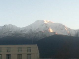
Since Monday the 27th, we've received .19 inches of water at our Old Ski Bowl weather station at 7,600 feet. High snow levels to start the week gave us some rain at times at Bunny Flat (6,950).Overall, no more than a skiff of new snow can be found above 6,500 feet on Mt Shasta. The snow level has generally been around 8,000 feet this past week. Temperatures have fallen and it feels a little more winter like, but I don't expect much more, if any, precipitation for the remaining weekend.
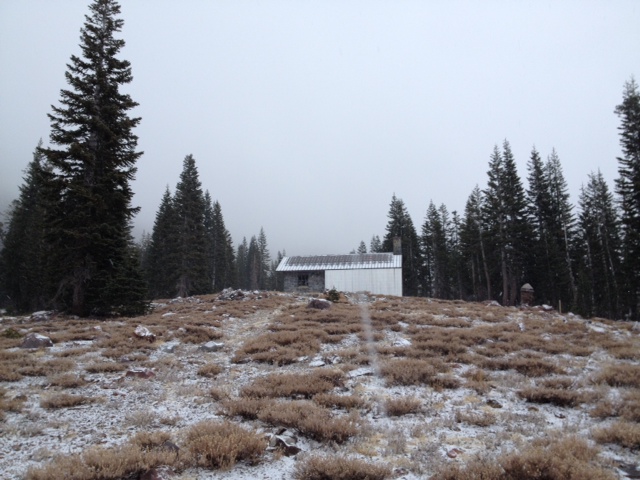
A picture of Horse Camp taken on 1/30/14. As you can see, we didn't get much snow out of this latest storm! Photo: M. Nova
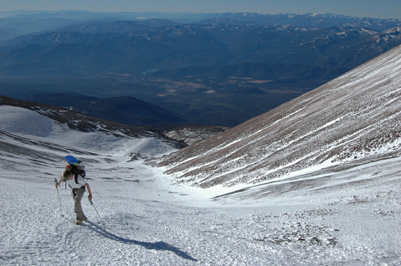
Some skiing to be had in Cascade Gulch! This photo taken a couple weeks ago. One must walk to upper Hidden Valley before skinning up. Photo: C. Carr
---------------------------------------------------------------------------------------------------------------------------------------------------------------
All trailheads are still accessible by vehicle. Be cautious of any overnight trips on the mountain with snow involved. Storms can easily dump large amounts of snow to the area and make it difficult to drive off the mountain! While Northgate, Brewer Ck and Clear Ck trailheads are officially closed, the bathrooms are still open with packout bags inside, and one can still access the Mt Shasta Wilderness. However, your summit pass and wilderness permits must be purchased at McCloud or Mt Shasta Ranger Stations. NO DOGS are allowed in the Mt Shasta Wilderness OR Sierra Club Property. Thanks!
---------------------------------------------------------------------------------------------------------------------------------------------------------------
Below are a few aerial pictures taken during the middle of December. Conditions look much the same currently, if not less snow.
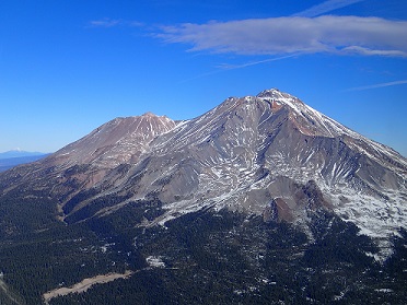
Aerial photo of the South side of Mt. Shasta, taken 12-18-13. (Photo: H Meyers)
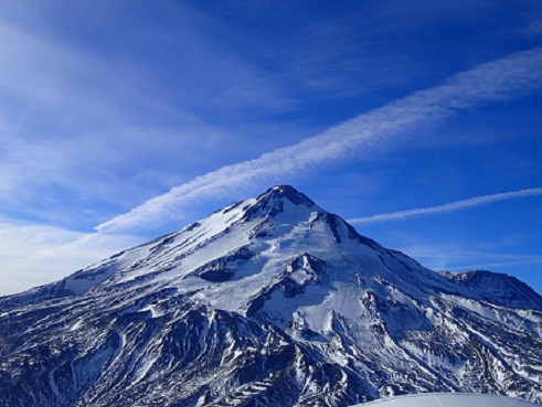
The North Side of Mt. Shasta with the Hotlam Glacier in center, Hotlam/Wintun ridge left, Shastina to the far right. Taken 12-18-13. (Photo: H Meyers)
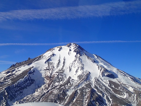
The East side of Mt. Shasta, taken 12-18-13 (Photo: H Meyers)
---------------------------------------------------------------------------------------------------------------------------------------------------------------
Terrain: Remember most of the terrain that we like to play on is greater than 30 degrees. Avalanches are possible on anything steeper than 30 degrees. Avoid cornices, rock bands, terrain traps and runout zones of avalanche paths.
Weather: Most of our areas avalanche danger will occur 24-48 hours after a storm. We still can see persistent weak layers from time to time and we always will be sure to let you know about that! Heed the basic signs: Wind (significant snow transport and depositions), Temperature (rain/snow/rain/snow, which in turn weakens the snowpack), and Precipitation (Snow or rain add weight and stress to the current snowpack).
Snowpack: If snow accumulates, give the snowpack a chance to adjust to the new snow load before you play on or near steep slopes (greater than 30 degrees). Most direct action avalanches occur within 24-48 hours of recent snowfall. Watch for obvious signs of snowpack instability such as recent natural avalanche activity, collapsing of the snowpack (often associated with a “whumphing” sound), and shooting cracks. If you see these signs of instability, limit your recreation to lower angle slopes.
Human Factor: Don’t forget to carry and know how to use avalanche rescue gear. You should NOT be skiing or climbing potential avalanche slopes without having beacons, shovels, and probes. Only one person in a group should be exposed to potential avalanche danger at a time. Remember, climbing, skiing, and riding down the edge of slopes is safer than being in the center. Just because another person is on a slope doesn’t mean that it is safe. Be an individual! Make your own decisions. Heed the signs of instability: rapid warming, “whumphing” noises, shooting cracks, snowing an inch an hour or more, rain, roller balls, wind loading, recent avalanche activity.
Weather and Current Conditions
Weather Summary
In Mt Shasta City this morning at 0500, we have partly cloudy skies and a current temperature of 33 F.
On Mt Shasta (South Side) in the last 24 hours...
Old Ski Bowl - 7,600 feet, we've had no new snow and a snow depth total of up to 5 inches at best in shaded pockets. The current temperature is 17F with a low of 16F and a high of 29F.
Gray Butte - 8,000 feet, the current temperature is 15F. Temps have ranged from a low of 15F to a high 27F. Winds averaged 8mph with gusts to 21 mph, west/southwest
Castle Lake and Mt Eddy (West side of I-5)...
Castle Lake - 5,600 feet, the current temperature is 23F with a low of 19F and a high of 35F. Castle Lake has received no new snow with a current snowpack of 0-5 inches in more shaded areas.
Mt Eddy - 6,500 feet, the current temperature is 20F with a low of 14F and a high of 28F. Mt Eddy has no new snow over and a current snow depth total of 0-5 inches at best. Winds have averaged 2 mph with gusts to 9 mph, southerly in nature.
THIS SEASON: Since September 1st (the wet season), we have received 3.03 inches of water, normal is 23.18 inches, putting us at 13% of normal. For the year of 2014, Mt Shasta has received 0.21 inches of water with normal being 7.30 inches which puts us at 2% of normal. And lastly, for February, we've received 0.00 inches of water, normal is .24 inches.
Mt Shasta finished off 2013 with exactly 10.00 inches of water, normal is 43.21", putting us at 23% of normal. A DESERT is classified as an area that receives 10 inches of water or less per year. Yikes! ![]()
December 2012 had more precipitation than the entire 2013 calendar year (10.43"). WOW!
WEATHER SYNOPSIS:
Low pressure slides down the coast of California today. The edge of this storm will provide partly cloudy conditions with fleeting moments of precipitation today through Monday, otherwise we'll enter a waiting period of clearing and sunny skies for the week. The carrot continues to dangle in front of us hinting a significant storm and/or wet period beginning near next weeeknd. With cold air in place, snow is likely for Mt Shasta.
Winds will increase on the mountain above treeline tomorrow. Expect a steady 20-30 mph with gusts to 40-50 mph, Northwest.
| 0600 temperature: | 19 |
| Max. temperature in the last 24 hours: | 30 |
| Average wind direction during the last 24 hours: | Southerly |
| Average wind speed during the last 24 hours: | 8 mi/hr |
| Maximum wind gust in the last 24 hours: | 21 mi/hr |
| New snowfall in the last 24 hours: | 0 inches |
| Total snow depth: | 0-5 inches |
Two Day Mountain Weather Forecast
Produced in partnership with the Medford NWS
| For 7000 ft to 9000 ft | |||
|---|---|---|---|
|
Sunday (4 a.m. to 10 p.m.) |
Sunday Night (10 p.m. to 4 a.m.) |
Monday (4 a.m. to 10 p.m.) |
|
| Weather | Slight chance of snow showers after 10am, otherwise partly sunny | Slight chance of snow showers after 4 am, mostly cloudy | Partly Sunny, slight chance of snow showers |
| Temperature (°F) | 30 | 23 | 27 |
| Wind (mi/hr) | South 10-15 mph | West/southwest 5-10mph | North/northwest 10-15mph, gusts to 20mph |
| Precipitation SWE / Snowfall (in) | / trace | / trace | / 0 |
| For 9000 ft to 11000 ft | |||
| Sunday | Sunday Night | Monday | |
| Weather | Slight chance of snow showers after 10am, otherwise partly sunny | Slight chance of snow showers, mostly cloudy | Slight chance of snow showers, Partly Sunny |
| Temperature (°F) | 24 | 9 | 22 |
| Wind (mi/hr) | South/southwest 10-15 mph | West trace | Northwest 30-40mph, gusts higher |
| Precipitation SWE / Snowfall (in) | / trace | / 0 | / 0 |

