

You are here
Avalanche Advisory for 2014-02-07 07:01:11
- EXPIRED ON February 8, 2014 @ 7:01 amPublished on February 7, 2014 @ 7:01 am
- Issued by Nick Meyers - Shasta-Trinity National Forest
Bottom Line
A winter storm is upon us, finally. It will still take a good bit of snow to cover up avalanche terrain and warrant any further avalanche danger. Currently, the avalanche danger is LOW and normal caution is advised for all aspects and elevations. One to two feet of new snow is expected near and above treeline on Mt Shasta by the end of the weekend, accompanied by strong westerly winds.
Rockfall is still a hazard on Mt. Shasta until we receive significant snow. Climbing is not recommended on select routes. Be sure to check the climbing advisory if you still choose to climb.


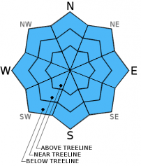
Avalanche Problem 1: Normal Caution
-
Character ?

-
Aspect/Elevation ?
-
Likelihood ?CertainVery LikelyLikelyPossible
 Unlikely
 -
Size ?HistoricVery LargeLargeSmall

The avalanche danger on Mt Shasta's glaciers and all other areas hosting snow is LOW. Normal caution advised. Skiing on the glaciers at this time is rough and icy. Be cautious of open bergshrunds, crevasses, ice patches, and rock/ice fall. Self arrest may be difficult with current conditions. Always keep an eye and ear out for rock fall.
Other skiable areas (not many!) host variable snow textures. Normal caution advised. If you find yourself climbing or skiing one of the many skinny, snow-filled gullies...keep in mind that these gullies can host much more rockfall than open slopes as they act like a funnel for any loose rocks descending the mountain. IF you choose to climb, WEAR A HELMET PROPERLY - That is, fit snugly to your head with the front of the helmet directly over your eyebrow line. Further, know how to use your ice axe and crampons!
Recent Observations
Well,... Fall is drawing to a close in February and winter appears to have commenced here in and on Mt Shasta beginning yesterday at noon at our Old Ski Bowl (OSB) weather station, nicely positioned at the bottom of the Old Ski Bowl on the south side of Shasta at 7,600 feet. At the weather station, new snow depth totals are still meager, but we are certain this will change by the end of the weekend. OSB water total thus far is .29 inches, giving us a couple inches of fresh snow. In Mt Shasta City, we received .04 inches of water and a skiff of snow, though it's raining as we speak. Warm ground temperatures have kept all our new snow melting quickly in town.
It's still going to take a good dollup of snow for any avalanche danger to be present. Once we get a decent snowpack going, we'll begin to talk about snow in detail! We are expecting a foot or more of new snow above 6,000 feet by the end of the weekend.
As always when our snowpack is shallow, watch out for objects that can cause injury near the surface of the snow!
---------------------------------------------------------------------------------------------------------------------------------------------------------------
All trailheads are still accessible by vehicle. Be cautious of any overnight trips on the mountain with snow involved. Storms can easily dump large amounts of snow to the area and make it difficult to drive off the mountain! While Northgate, Brewer Ck and Clear Ck trailheads are officially closed, the bathrooms are still open with packout bags inside, and one can still access the Mt Shasta Wilderness. However, your summit pass and wilderness permits must be purchased at McCloud or Mt Shasta Ranger Stations. NO DOGS are allowed in the Mt Shasta Wilderness OR Sierra Club Property. Thanks!
---------------------------------------------------------------------------------------------------------------------------------------------------------------
Terrain: Remember most of the terrain that we like to play on is greater than 30 degrees. Avalanches are possible on anything steeper than 30 degrees. Avoid cornices, rock bands, terrain traps and runout zones of avalanche paths.
Weather: Most of our areas avalanche danger will occur 24-48 hours after a storm. We still can see persistent weak layers from time to time and we always will be sure to let you know about that! Heed the basic signs: Wind (significant snow transport and depositions), Temperature (rain/snow/rain/snow, which in turn weakens the snowpack), and Precipitation (Snow or rain add weight and stress to the current snowpack).
Snowpack: If snow accumulates, give the snowpack a chance to adjust to the new snow load before you play on or near steep slopes (greater than 30 degrees). Most direct action avalanches occur within 24-48 hours of recent snowfall. Watch for obvious signs of snowpack instability such as recent natural avalanche activity, collapsing of the snowpack (often associated with a “whumphing” sound), and shooting cracks. If you see these signs of instability, limit your recreation to lower angle slopes.
Human Factor: Don’t forget to carry and know how to use avalanche rescue gear. You should NOT be skiing or climbing potential avalanche slopes without having beacons, shovels, and probes. Only one person in a group should be exposed to potential avalanche danger at a time. Remember, climbing, skiing, and riding down the edge of slopes is safer than being in the center. Just because another person is on a slope doesn’t mean that it is safe. Be an individual! Make your own decisions. Heed the signs of instability: rapid warming, “whumphing” noises, shooting cracks, snowing an inch an hour or more, rain, roller balls, wind loading, recent avalanche activity.
Weather and Current Conditions
Weather Summary
In Mt Shasta City this morning at 0500, we have some light rain falling and a current temperature of 35 F.
On Mt Shasta (South Side) in the last 24 hours...
Old Ski Bowl - 7,600 feet, we've had 2-4 inches new snow that began to fall at 1200 on the 6th. Our current snow depth total at the Old Ski Bowl site is 3-5 inches and growing we hope! The current temperature is 20F with a low of 17F and a high of 20F.
Gray Butte - 8,000 feet, the current temperature is 20F. Temps have ranged from a low of 16F to a high 20F. Winds averaged 5mph with gusts to 14 mph, west to northwest.
Castle Lake and Mt Eddy (West side of I-5)...
Castle Lake - 5,600 feet, the current temperature is 26F with a low of 22F and a high of 30F. Castle Lake has received 1-2 inches of new snow with a current snowpack of 1-3 inches.
Mt Eddy - 6,500 feet, the current temperature is 22F with a low of 21F and a high of 26F. Mt Eddy has 1-2 inches new snow and a current snow depth total of 1-3 inches. Winds have averaged 2 mph with gusts to 12 mph, southeast in nature.
THIS SEASON: Since September 1st (the wet season), we have received 3.07 inches of water, normal is 24.40 inches, putting us at 12% of normal. For the year of 2014, Mt Shasta has received 0.25 inches of water with normal being 8.52 inches which puts us at 2% of normal. And lastly, for February we are 2% of normal, receiving 0.04 inches of water, normal is 1.46 inches.
Mt Shasta finished off 2013 with exactly 10.00 inches of water, normal is 43.21", putting us at 23% of normal. A DESERT is classified as an area that receives 10 inches of water or less per year. Yikes! ![]()
December 2012 had more precipitation than the entire 2013 calendar year (10.43"). WOW!
WEATHER SYNOPSIS:
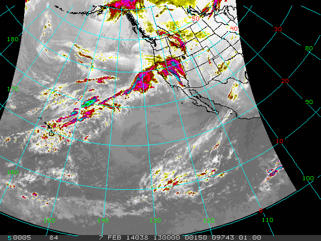
A nice looking satellite photo this morning compared to what we've been seeing! A long chain of storms, extending out from Hawaii, is lined up to hit our area right now and through the weekend. A little over 2.5 inches of water is expected by Monday for Mt Shasta, a much welcomed reprieve from the dry conditions this winter has provided. A litte disconcerting for this series of storms will be the gradual temperature rise we'll see as the weekend progresses. This morning, snow levels will start near 3,500 feet at best. Cold air begins to move out of the area as we speak and it will be a gradual crescendo for temps through the weekend, with snow levels rising to as high as 7,000 feet by Sunday.
Winds should start cranking above treeline on Shasta later today and tomorrow. I wouldn't be surprised to see wind speeds averaging 30-50 mph out of the west with gusts higher as always!
| 0600 temperature: | 23 |
| Max. temperature in the last 24 hours: | 24 |
| Average wind direction during the last 24 hours: | West/Northwest |
| Average wind speed during the last 24 hours: | 5 mi/hr |
| Maximum wind gust in the last 24 hours: | 14 mi/hr |
| New snowfall in the last 24 hours: | 1-3" inches |
| Total snow depth: | 1-5" inches |
Two Day Mountain Weather Forecast
Produced in partnership with the Medford NWS
| For 7000 ft to 9000 ft | |||
|---|---|---|---|
|
Friday (4 a.m. to 10 p.m.) |
Friday Night (10 p.m. to 4 a.m.) |
Saturday (4 a.m. to 10 p.m.) |
|
| Weather | SNOW! | SNOW! | SNOW! |
| Temperature (°F) | 28 | 27 | 36 |
| Wind (mi/hr) | South 15-20mph | South 20-30mph | South 20-30mph |
| Precipitation SWE / Snowfall (in) | / 4-8 | / 4-8 | / 3-5 |
| For 9000 ft to 11000 ft | |||
| Friday | Friday Night | Saturday | |
| Weather | SNOW! | SNOW! | SNOW! |
| Temperature (°F) | 23 | 22 | 27 |
| Wind (mi/hr) | Southwest 40-50mph with gusts higher | West/Southwest 5-9 | West 50-60mph |
| Precipitation SWE / Snowfall (in) | / 5-9 | / 4-8 | / 3-5 |

