

You are here
Avalanche Advisory for 2014-02-21 06:56:49
- EXPIRED ON February 22, 2014 @ 6:56 amPublished on February 21, 2014 @ 6:56 am
- Issued by Nick Meyers - Shasta-Trinity National Forest
Bottom Line
The avalanche danger is LOW for all aspects and elevations. Caution is advised if you find yourself on slopes >35 degrees hosting isolated wind/hard slabs on top of existing snow.
Climbers: ROCK & RIME ICE FALL will be a hazard this weekend. The snowpack is still shallow (1-2 feet) and a slip and fall on hard, firm snow without self arrest skills will likely involve sliding into rock(s).
Climbing is not recommended on select routes. Be sure to check the climbing advisory if you still choose to climb.


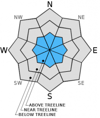
Avalanche Problem 1: Wind Slab
-
Character ?

-
Aspect/Elevation ?
-
Likelihood ?CertainVery LikelyLikelyPossible
 Unlikely
 -
Size ?HistoricVery LargeLargeSmall

Mt Shasta has received .07 inches of water during this past weeks "storm", resulting in a couple inches of new snow above 6,900 feet on Shasta. Northwest winds blew for most of the week and peaked on Wednesday morning with gusts to 80mph. Much of our old snow is rock solid and wind scoured. However, leeward slopes, gullies, depressions, and lower lying areas (above treeline) host a mix of wind packed powder and harder wind slabs. Yesterday, small hollow sounding wind slabs were present in the Old Ski Bowl. One should use caution when on wind slabs sitting on firm, old snow on steeper slopes (>35 degrees). Wind slabs will be small in size with isolated distribution.
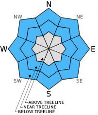
Avalanche Problem 2: Normal Caution
-
Character ?

-
Aspect/Elevation ?
-
Likelihood ?CertainVery LikelyLikelyPossible
Unlikely
-
Size ?HistoricVery LargeLargeSmall
The snowpack on Mt Shasta is firm! Northwest winds have beat the mountain over this past week and scoured much of our snowpack down to ice and hard snow. While these hard, firm areas host low avalanche danger, a slip and fall on hard, smooth snow without self-arrest skills could result in a long fall over snow and rock. If climbing this weekend, please be careful.
Recent Observations
The "storm" of this past week gave us .07 inches of water which translated to just a few inches of snow on the mountain. All of this fell above 6,000 feet. This occured early Wednesday morning and then was followed by strong NW winds averaging 40-50 mph and gusting to 80 mph Wednesday morning. Much of the new snow sublimated on the upper mountain (above 12,000 feet). However gullies, depressions and low lying leeward areas collected some of this new snow and provided for some moments of decent skiing near and above treeline to 12k. Overall, it's a mix between hard, firm conditions, isolated wind slabs and pockets of powder.
Any recent pictures you might have seen of Shasta make it look like conditions are pretty good. I suppose it IS good considering our winter, however in reality, there is only about 1-2 feet of snow on the mountain. Many of the rocks are white and look covered, but this is rime ice and not snow. Anybody wishing to climb this weekend is cautioned: rock and rime ice fall will be a hazard, especially during the warmest portions of the day. A slip and fall on any existing snow, without self-arrest skills, will likely involve sliding into rocks. Not good.
That being said, locals have been having a great time skiing the lower to mid elevation gullies hosting wind blown powder. Still, be careful of shallow buried objects.
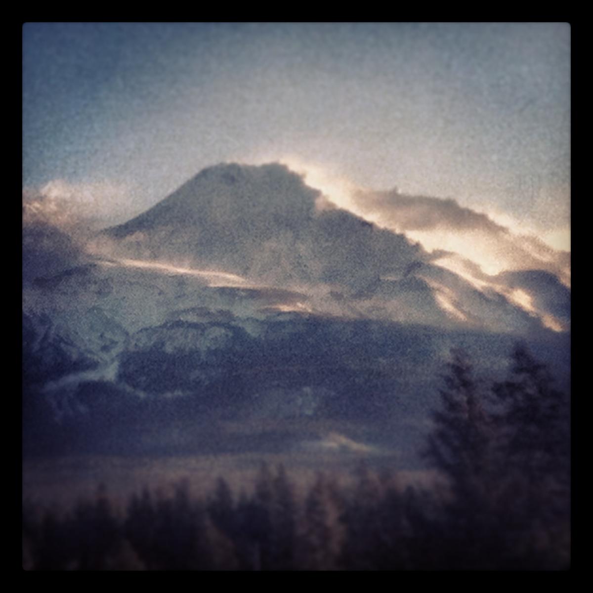
Wind event, Feb 19th, 2014...Northwest, averaging 40-50 mph with gusts to 80 mph. [Photo: N Meyers]
---------------------------------------------------------------------------------------------------------------------------------------------------------------
Some trailheads are still accessible by 4 x 4 vehicle. Be cautious of any overnight trips on the mountain with snow involved. Storms can easily dump large amounts of snow to the area and make it difficult to drive off the mountain! While Northgate, Brewer Ck and Clear Ck trailheads are officially closed, the bathrooms are still open with packout bags inside, and one can still access the Mt Shasta Wilderness. However, your summit pass and wilderness permits must be purchased at McCloud or Mt Shasta Ranger Stations. NO DOGS are allowed in the Mt Shasta Wilderness OR Sierra Club Property. Thanks!
---------------------------------------------------------------------------------------------------------------------------------------------------------------
Terrain: Remember most of the terrain that we like to play on is greater than 30 degrees. Avalanches are possible on anything steeper than 30 degrees. Avoid cornices, rock bands, terrain traps and runout zones of avalanche paths.
Weather: Most of our areas avalanche danger will occur 24-48 hours after a storm. We still can see persistent weak layers from time to time and we always will be sure to let you know about that! Heed the basic signs: Wind (significant snow transport and depositions), Temperature (rain/snow/rain/snow, which in turn weakens the snowpack), and Precipitation (Snow or rain add weight and stress to the current snowpack).
Snowpack: If snow accumulates, give the snowpack a chance to adjust to the new snow load before you play on or near steep slopes (greater than 30 degrees). Most direct action avalanches occur within 24-48 hours of recent snowfall. Watch for obvious signs of snowpack instability such as recent natural avalanche activity, collapsing of the snowpack (often associated with a “whumphing” sound), and shooting cracks. If you see these signs of instability, limit your recreation to lower angle slopes.
Human Factor: Don’t forget to carry and know how to use avalanche rescue gear. You should NOT be skiing or climbing potential avalanche slopes without having beacons, shovels, and probes. Only one person in a group should be exposed to potential avalanche danger at a time. Remember, climbing, skiing, and riding down the edge of slopes is safer than being in the center. Just because another person is on a slope doesn’t mean that it is safe. Be an individual! Make your own decisions. Heed the signs of instability: rapid warming, “whumphing” noises, shooting cracks, snowing an inch an hour or more, rain, roller balls, wind loading, recent avalanche activity.
Weather and Current Conditions
Weather Summary
In Mt Shasta City this morning at 0500, we have clear skies with a current temperature is 32 F.
On Mt Shasta (South Side) in the last 24 hours...
Old Ski Bowl - 7,600 feet. Over the week, Mt Shasta received .07 inches of water between midnight and 0500 on the 19th, resulting in an skiff of new snow. Shasta has received no new snow in the last 24 hours. Our current snow depth total at the Old Ski Bowl is 28 inches. The current temperature is 24F with a low of 21F and a high of 39F.
Gray Butte - 8,000 feet - The current temperature is 24F. Temps have ranged from a low of 22F to a high 34F. Winds have been variable in nature, averaging 7 mph with gusts to 35mph from the west at 1400.
Castle Lake and Mt Eddy (West side of I-5)...
Castle Lake - 5,600 feet, the current temperature is 29F with a low of 22F and a high of 40F. Castle Lake has received no new snow and a current snowpack of 2-4 inches. Castle received a trace of snow during the small storm on the 19th.
Mt Eddy - 6,500 feet, the current temperature is 29F with a low of 24F and a high of 37F. Mt Eddy has no new snow and a current snow depth total of 7 inches. Mt Eddy received a skiff of snow on the morning of the 19th also. Winds have averaged 2 mph with gusts to 10 mph, southerly in nature.
THIS SEASON: Since September 1st (the wet season), we have received 6.39 inches of water, normal is 28.00 inches, putting us at 22% of normal. For the year of 2014, Mt Shasta has received 3.57 inches of water with normal being 12.12 inches which puts us at 29% of normal. And lastly, for February we are 66% of normal, receiving 3.36 inches of water, normal is 5.06 inches.
WEATHER SYNOPSIS:
We will be rocking the classic's for the coming weekend...that is dry northwest flow, calm winds and generally sunny skies. Winds look to be calm and nothing much of note to mention. Our next best chance at winter weather will be next week, maybe. We all know how that has been going this season. Dangle a big carrot and as you get closer, it gets smaller! At this point, lets keep it in the now! Enjoy the weekend.
| 0600 temperature: | 24 |
| Max. temperature in the last 24 hours: | 39 |
| Average wind direction during the last 24 hours: | Variable |
| Average wind speed during the last 24 hours: | 7 mi/hr |
| Maximum wind gust in the last 24 hours: | 35 mi/hr |
| New snowfall in the last 24 hours: | 0 inches |
| Total snow depth: | 28 inches |
Two Day Mountain Weather Forecast
Produced in partnership with the Medford NWS
| For 7000 ft to 9000 ft | |||
|---|---|---|---|
|
Friday (4 a.m. to 10 p.m.) |
Friday Night (10 p.m. to 4 a.m.) |
Saturday (4 a.m. to 10 p.m.) |
|
| Weather | Mostly sunny | Mostly clear | Sunny |
| Temperature (°F) | 43 | 23 | 43 |
| Wind (mi/hr) | Northwest Calm | North 5-10mph | North 5-10mph |
| Precipitation SWE / Snowfall (in) | / 0 | / 0 | / 0 |
| For 9000 ft to 11000 ft | |||
| Friday | Friday Night | Saturday | |
| Weather | Mostly sunny | Mostly clear | Sunny |
| Temperature (°F) | 35 | 15 | 35 |
| Wind (mi/hr) | Northwest 5-15mph | North 0 | North 10-20mph |
| Precipitation SWE / Snowfall (in) | / 0 | / 0 | / 0 |

