

You are here
Avalanche Advisory for 2014-03-07 07:05:52
- EXPIRED ON March 8, 2014 @ 7:05 amPublished on March 7, 2014 @ 7:05 am
- Issued by Nick Meyers - Shasta-Trinity National Forest
Bottom Line
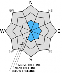
A thick crust due to rain on snow has created LOW avalanche danger for below and near treeline areas. Above treeline, for areas above 9,000 feet, MODERATE avalanche danger exists for wind slab avalanches near ridgetops and bowls.


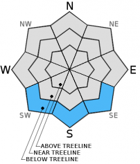
Avalanche Problem 1: Wind Slab
-
Character ?

-
Aspect/Elevation ?
-
Likelihood ?CertainVery LikelyLikelyPossible
 Unlikely
 -
Size ?HistoricVery LargeLargeSmall

Out of the last 5 days, winds have primarily blown out of the west, southwest and a bit from the northwest. Primary concern for wind slabs will remain for elevations above the rain/snow level, which is generally above 9,000 feet. Leeward, N, NE, E, SE and S aspects near ridgetops and bowls should be most suspect for wind slabs and triggering said wind slabs is possible.
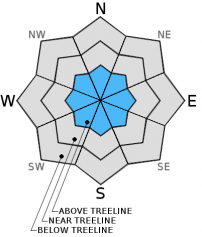
Avalanche Problem 2: Wet Slab
-
Character ?

-
Aspect/Elevation ?
-
Likelihood ?CertainVery LikelyLikelyPossible
Unlikely
-
Size ?HistoricVery LargeLargeSmall
Cooler overnight temperatures and a thick, 2 inch crust has locked up the snowpack well in the past few days. An unlikely chance of a wet avalanche on lower elevation, sun warmed slopes exists today as temperatures near their high.
Avalanche Problem 3: Cornice
-
Character ?

-
Aspect/Elevation ?
-
Likelihood ?CertainVery LikelyLikelyPossible
Unlikely
-
Size ?HistoricVery LargeLargeSmall
Always be cautious of corniced ridgelines when new snow and winds are present. Stay back on terra firma as cornices can break back much further than expected.
Recent Observations
---------------------------------------------------------------------------------------------------------------------------------------------------------------
While Northgate, Brewer Ck and Clear Ck trailheads are officially closed, the bathrooms are still open with packout bags inside, and one can still access the Mt Shasta Wilderness. However, your summit pass and wilderness permits must be purchased at McCloud or Mt Shasta Ranger Stations. NO DOGS are allowed in the Mt Shasta Wilderness OR Sierra Club Property. Thanks!
---------------------------------------------------------------------------------------------------------------------------------------------------------------
Terrain: Remember most of the terrain that we like to play on is greater than 30 degrees. Avalanches are possible on anything steeper than 30 degrees. Avoid cornices, rock bands, terrain traps and runout zones of avalanche paths.
Weather: Most of our areas avalanche danger will occur 24-48 hours after a storm. We still can see persistent weak layers from time to time and we always will be sure to let you know about that! Heed the basic signs: Wind (significant snow transport and depositions), Temperature (rain/snow/rain/snow, which in turn weakens the snowpack), and Precipitation (Snow or rain add weight and stress to the current snowpack).
Snowpack: If snow accumulates, give the snowpack a chance to adjust to the new snow load before you play on or near steep slopes (greater than 30 degrees). Most direct action avalanches occur within 24-48 hours of recent snowfall. Watch for obvious signs of snowpack instability such as recent natural avalanche activity, collapsing of the snowpack (often associated with a “whumphing” sound), and shooting cracks. If you see these signs of instability, limit your recreation to lower angle slopes.
Human Factor: Don’t forget to carry and know how to use avalanche rescue gear. You should NOT be skiing or climbing potential avalanche slopes without having beacons, shovels, and probes. Only one person in a group should be exposed to potential avalanche danger at a time. Remember, climbing, skiing, and riding down the edge of slopes is safer than being in the center. Just because another person is on a slope doesn’t mean that it is safe. Be an individual! Make your own decisions. Heed the signs of instability: rapid warming, “whumphing” noises, shooting cracks, snowing an inch an hour or more, rain, roller balls, wind loading, recent avalanche activity.
Weather and Current Conditions
Weather Summary
In Mt Shasta City this morning at 0500, we have partly cloudy skies with a current temperature of 34 F.
On Mt Shasta (South Side) in the last 24 hours...
Old Ski Bowl - 7,600 feet. Old Ski Bowl has received 1-3 inches in the last 24 hours. The current temperature is 21F with a low of 21F and a high of 30F. Total snow depth is 60 inches.
Gray Butte - 8,000 feet - The current temperature is 22F. Temps have ranged from a low of 22F to a high 28F. Winds have averaged 18 mph from the SW and switching to NW at noon yesterday. Gusts hit 42 mph from the WNW at 1300-1400.
Castle Lake and Mt Eddy (West side of I-5)...
Castle Lake - 5,600 feet, the current temperature is 29F with a low of 28F and a high of 40F. Castle Lake has received no new snow and has a current snowpack of 4-6 inches.
Mt Eddy - 6,500 feet, the current temperature is 22F with a low of 22F and a high of 36F. Mt Eddy has received 1-2 inches new snow and hosts current snow depth of 23 inches. Winds have averaged 2 mph with gusts to 12 mph, southerly in nature.
THIS SEASON: Since September 1st , we have received 10.75 inches of water, normal is 31.67 inches, putting us at 33% of normal. For the year of 2014, Mt Shasta has received 7.93 inches of water with normal being 15.79 inches which puts us at 50% of normal. And lastly, for March we sit at 126% of normal, receiving 1.89 inches of water, normal is 1.50 inches.
WEATHER SYNOPSIS:
Mt Shasta will get a brief break in the weather today. Generally sunny skies and calm winds will host this fine Friday! Increasing clouds will bring in the weekend and another wet blast of weather is due Saturday afternoon/evening. This storm will bring upwards of 1.2 inches of water by Monday morning. Unfortunately, a story all to familiar, warm air temperatures will cause snow levels to begin at 8,000 to 9,000 feet. Temps will lower, as will the snow level, as the storm moves through the area. This will likely be to little, to late and thus we'll probably see rain on snow for most of the lower and mid elevation areas on Shasta and snow at upper elevations. Hopefully we will see a transition to snow by Sunday for lower elevation areas, possibly as low as 4,000 to 5,000 feet.
| 0600 temperature: | 21 |
| Max. temperature in the last 24 hours: | 30 |
| Average wind direction during the last 24 hours: | SW - NW |
| Average wind speed during the last 24 hours: | 18 mi/hr |
| Maximum wind gust in the last 24 hours: | 42 mi/hr |
| New snowfall in the last 24 hours: | 1-3 inches |
| Total snow depth: | 60 inches |
Two Day Mountain Weather Forecast
Produced in partnership with the Medford NWS
| For 7000 ft to 9000 ft | |||
|---|---|---|---|
|
Friday (4 a.m. to 10 p.m.) |
Friday Night (10 p.m. to 4 a.m.) |
Saturday (4 a.m. to 10 p.m.) |
|
| Weather | Partly cloudy to sunny | Partly cloudy | Increasing clouds, rain, mainly after 4pm |
| Temperature (°F) | 47 | 30 | 49 |
| Wind (mi/hr) | West / Southwest Calm, increasing to 5-10 mph in the morning | Calm Calm | South / Southeast 5-10mph |
| Precipitation SWE / Snowfall (in) | / 0 | / 0 | / 0 - trace |
| For 9000 ft to 11000 ft | |||
| Friday | Friday Night | Saturday | |
| Weather | Partly cloudy to sunny | Partly cloudy | Increasing clouds, snow, mainly after 4pm |
| Temperature (°F) | 39 | 24 | 40 |
| Wind (mi/hr) | Variable Light, 0-10mph | West / Southwest 0 | West / Southwest 10-15 mph |
| Precipitation SWE / Snowfall (in) | / 0 | / 0 | / 0-1 |

