

You are here
Avalanche Advisory for 2016-03-11 07:12:51
- EXPIRED ON March 12, 2016 @ 7:12 amPublished on March 11, 2016 @ 7:12 am
- Issued by Nick Meyers - Shasta-Trinity National Forest
Bottom Line
Heavy snow, wind and rain on snow will host wind slabs, storm slabs and loose-wet related avalanche problems today. We have several RED FLAGS of avalanche danger checked off. This will continue for the next several days as a series of potent winter storms impact the area.
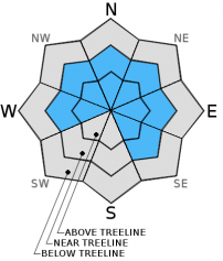
Below treeline, expect MODERATE danger for loose-wet slides. Near treeline, MODERATE danger with pockets of CONSIDERABLE for wind/storm slabs & loose-wet slides. Above treeline, CONSIDERABLE danger for wind/storm slabs.


Avalanche Problem 1: Wind Slab
-
Character ?

-
Aspect/Elevation ?
-
Likelihood ?CertainVery LikelyLikelyPossible
 Unlikely
 -
Size ?HistoricVery LargeLargeSmall

Wind slabs, new and existing, will be found near and above treeline today and continue to build. Use caution, conduct stability tests and don't trust them. Lack of above treeline observations leave uncertainty concerning wind slab stability. Unstable wind slabs are likely immediately during or just after snowy/windy periods. If you saw the photo of the Casaval slide from a few days ago, that is a classic example. If you didn't see it, log on to our Facebook page. Cross loading of slopes and mid-slope wind loaded areas are more common during extreme wind events. Wind can depost snow onto leeward aspects MUCH FASTER than snow falling from the sky. This means that wind slabs out there could be several feet thick. Thus, small to large wind slabs are possible. Above treeline areas will host the best chance of wind slab formation. Near and below treeline, the wet snow is difficult to move. Heavy, wet snow can also build big cornices. Use cornices as indicators of which way the wind has been blowing, and also....don't step out on the cornice! They can often break and subsequently trigger a larger slide below. Game over.
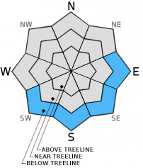
Avalanche Problem 2: Storm Slab
-
Character ?

-
Aspect/Elevation ?
-
Likelihood ?CertainVery LikelyLikelyPossible
Unlikely
-
Size ?HistoricVery LargeLargeSmall
New heavy, wet snow on top of possibly lighter density snow (just below March 7 crust) could create storm slab release. Rapid accumulation of snow builds on top of the March 7th crust with lighter density snow below the soft crust in areas. Conduct stability tests, dig hand pits to identify where heavier snow may sit on top of lighter snow.
New storm slabs could form with lower snow levels and lighter density snow. This isn't likely today but something to consider this weekend. Today, above treeline is protected areas and low lying gullies might be the best place for the rare storm slab. Warm temps have limited storm slabs overall.
Avalanche Problem 3: Loose Wet
-
Character ?

-
Aspect/Elevation ?
-
Likelihood ?CertainVery LikelyLikelyPossible
Unlikely
-
Size ?HistoricVery LargeLargeSmall
Small to medium sized donut rolls were observed yesterday on slopes steeper than 35 degrees. This morning, more of the same can be expected below treeline where heavy, wet (good snowman snow) still exists. Rain on snow may have squashed the snowpack well and loose-wet roller balls non-existent, but I bet on steeper slopes you could get some chunder going. Slopes with a consistent, steep, long fetch where the sticky snow has time to entrain more snow as it moves downhill and speeds up....these are the areas where loose-wet slides could get you into trouble. Add in a terrain trap or two and you could get into double trouble!
Temperatures will cool today and into tomorrow, perhaps 5-10 degrees below normal. As the temps cool, loose-wet problems will dwindle.
Recent Observations
After yesterday's outing, soggy and wet are the first two words that come to mind! Multiple objectives including snowpack analysis and weather station repair brought myself and a hardy volunteer up to Gray Butte via Bunny Flat, Mt Shasta. Warm temperatures in the morning, 6 degrees warmer than the day prior, should of been a good clue for what the day had in store. Snow struggled to fall at the 6,000 foot level. Elevations below that received mostly rain on snow. Look up at the mountains from town and you'll see where the snow starts to stick to the trees. For most of the day, a healthy serving of pea soup was the standard. Heavy mist, light rain and snow fell up until mid-late afternoon when a brief clearing gave way to decent visability and a glimpse at the mountain and surrounding hills. This leads me to my next point of discussion, the snowpack.
My partner and I did not observe any recent avalanches or eyebrow raising signs of instability yesterday on Gray Butte or the south side of the Mt Shasta. This is actually a bit concerning and makes me nervous. I would place good money that with the rapid precip rates, heavy snow, wind and several decent bed surfaces in place that we'd get some sort of action out there. Because we have not seen any avalanches/signs of instability occur... this leads me to believe that either - A) Continued ample snowfall will eventually cause a slab to fail and a big one at that, or B) the warmer temperatures of late have consolidated the snowpack into a stable, sticky, wet mass. I'm not quite on board with option B and lean more toward option A, especially since several more feet is very likely overt the weekend.
A snowpit was dug on a NW facing slope at 7,640 feet on Gray Butte, 35 degree slope. Two weaknesses in the snowpack were revealed, though seemingly not under high tension. Compression tests (CT14@20cm from top-Q3) failed fairly easily with poor shear quality/fracture character at 20 cm deep from the snow surface. This seemed to be simply a density change in the snow. Extended column tests (ECT24@47cm from top-Q3) failed at 47 cm deep in the snowpack, just below the March 7th crust layer. This ECT result was very similar to the day prior. Overall, 83cm of new snow since Sunday was recorded at this location. Our March 7th crust layer still exists and otherwise an isothermal, moist snowpack exists both below and above the 3/7 crust with 1 finger density hardness below the crust and fist to 4 finger hardneess above the crust. Moist and heavy keep coming to mind for our day, and the snow.
So...what should we make of this? Here is my thoughts: Stability tests and visual clues leaning toward an unstable snowpack are few. A couple roller balls occured yesterday...not a big concern unless on steep slopes with a long fetch. New, heavy snow continues to build, rapid precipitation rates are guaranteed, wind will blow and move snow around this weekend... We have several signs of the classic "5 Red Flags of Avalanche Danger" in place. As we move through these storm cycles this weekend, it's going to be very important to proceed cautiously if in avalanche terrain. We are getting to the point where large avalanches could be possible. Always look for signs of instability, NOT stability. If you don't find anything, keep looking.
Above treeline, we got a brief glimpse at things late in the day, but due to very poor visibility lately, hands on assesment of the snowpack has been nill. The Castle Lake road is closed and thus access difficult up there. Almost entirely rain on snow has been occuring at Castle Lake. On Mt Eddy, only the highest terrain has been seeing new snow. We do not have any recent obs from the Eddy area.
Today, all avalanche prone slopes with ample new snow, wind loaded leeward ridgelines, cornices...it should all be suspect. The snow is piling up quickly and is heavy. Existing wind slabs will continue to build in size with steady precipitation expected today. Southerly winds will load NW-N-NE-E-SE slopes. Changes in temperature and snow levels will create different density snow layering. It's often that these density changes act as the weak layer. Your 'A" game is going to be necessary and it might just be a good idea to stay off avalanche terrain entirely. Periods/pockets of HIGH avalanche danger are possible immediately during or just after these storms.
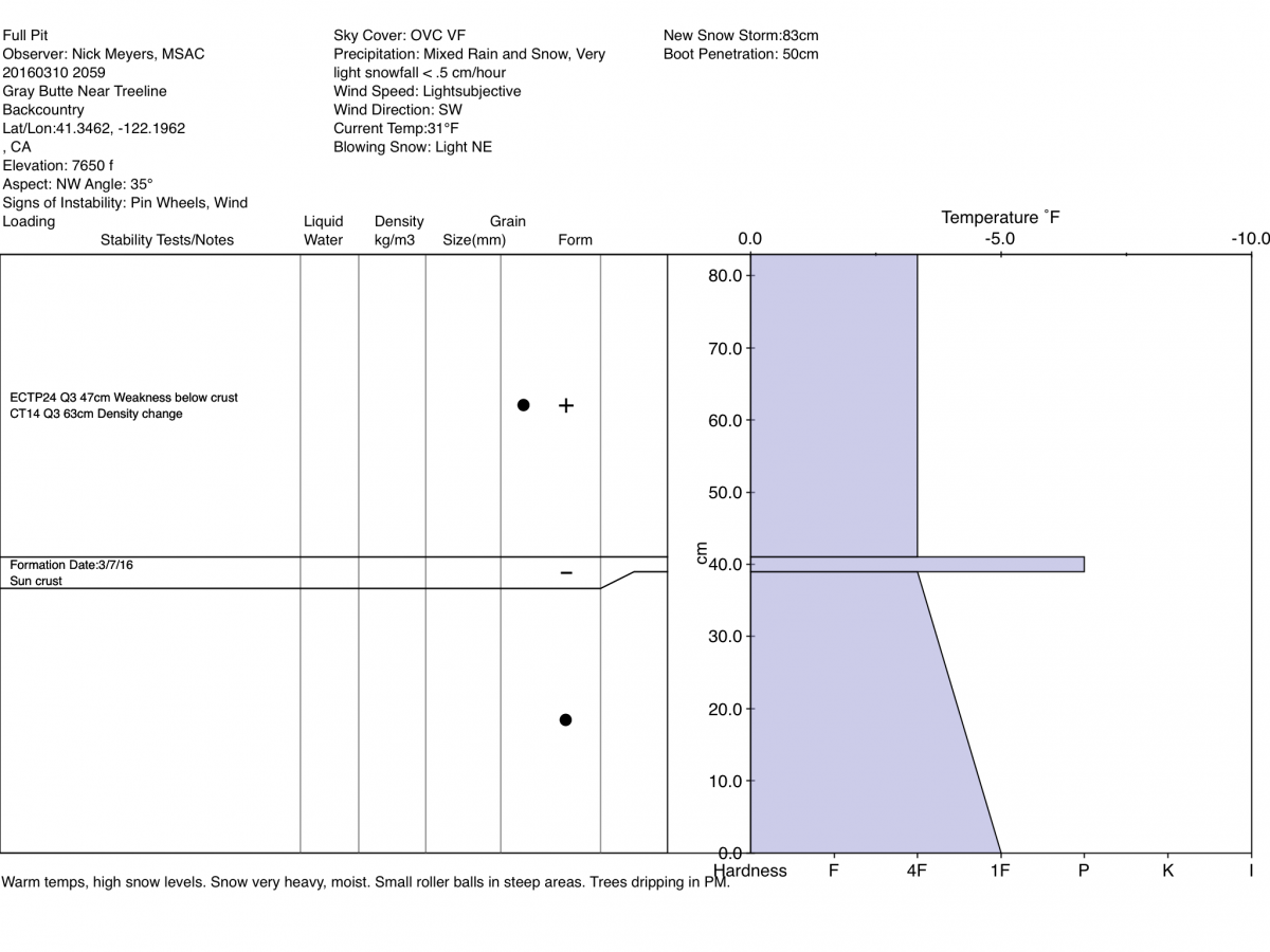
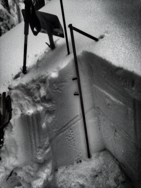
LEFT: Snowpit at 7,640 feet, NW aspect of Gray Butte, Mt. Shasta. Note crust layer / RIGHT - March 7th sun crust layer, 1-2cm thick.
-----------------------------------------------------------------------------------------------------------------------------------------------------------
LOCAL AREA ROAD, NORDIC, AND SNOWMOBILE PARK STATUS:
The Sand Flat cross country ski trails are in good shape and ready for your cross country skis and snow shoes. These are backcountry routes marked with blue diamonds on trees. Trails are not groomed. Snow shoers, please blaze a parallel trail to cross country skiers staying out of the skin track. These trails can be accessed via the Everett Memorial Highway. Thank you, and enjoy!
The Mt. Shasta Nordic Center is open! These beautiful, groomed trails can be accessed via the Ski Park Highway. http://www.mtshastanordic.org
The Pilgrim Creek & Deer Mountain Snowmobile Parks are open! Trails have not been groomed in the past week and a half due to warm temperatures. Head to our "Education" tab on our website and find the snowmobile section for trail information, grooming status, and other sledder resources.
The Castle Lake Road is CLOSED at the gate. The culvert blew out and we do not know when it will be repaired. The Everett Memorial Highway is plowed to Bunny Flat.
The Five Red Flags of Avalanche Danger any time of year include: 1) Recent/current avalanche activity 2) Whumphing sounds or shooting cracks 3) Recent/current heavy snowfall 4) Strong winds transporting snow 5) Rapid warming or rain on snow.
Weather and Current Conditions
Weather Summary
Good Morning! In Mt Shasta City at 0500, we have a current temperature of 42 F, one degree cooler than yesterday at this time. Skies are obscured with rain falling, heavy at times and windy.
On Mt Shasta (South Side) in the last 24 hours...
Old Ski Bowl - 7,600 feet, the current temperature is 28 degrees F. Snow on the ground totals 147 inches with 9 inches new snow and 1 inch of settlement. Temperatures have ranged from 28 F to 32 F.
Gray Butte - 8,000 feet, the current temperature is 27 degrees F. Temperatures have ranged from 27 F to 32 F. Winds have averaged 10-15 mph, southerly - with gusts to 28 mph, west through southeast.
Mt Eddy Range (West side of Interstate-5)...
Castle Lake - 5,600 feet, the current temperature is 32 degrees. Temperatures have ranged from 32 F to 39 F. Snow on the ground totals 66 inches with no new snow and 1 inch settlement due to rain on snow.
Mt Eddy - 6,500 feet, the current temperature is 31 degrees F. Temperatures have ranged from 30 F to 34 F. Snow on the ground measures 85 inches with 6 inches new snow and 2 inches settlement. Winds have averaged 2 mph with a max gust of 14 mph, south/southwest.
Always check the weather before you attempt to climb Mt Shasta. Further, monitor the weather as you climb. Becoming caught on the mountain in any type of weather can compromise life and limb. Be prepared.
WEATHER DISCUSSION:
Here we go...consistent with occaisonally heavy precipitation will continue for the forecast area today, and through the weekend. All things look impressive. From this morning until Sunday morning, 2.25 inches of water is forecast to fall. You're probably curious about the snow level, as I...and the good news is that temps WILL actually drop, to the tune of 5-10 degrees below normal on Saturday. It's looking like another day of highish snow levels, near 6,000 feet today. Tonight they'll drop to to near 5,000 feet and by Saturday, expect snow levels around 4,000 feet, perhaps lower during intense precipitation rates. The wind will blow, south/southwest, but not at gale force speeds like we've been seeing. Snow, snow and more snow for the mountains and a lot of rain for Mt Shasta City and the flanks of Mt Shasta. Unfortunately, much of the forecast area (Castle Lake, Mt Eddy) has been seeing temperatures struggle to drop below freezing and thus, not much new snow is being reported from those areas. Rain on snow is a factor and pockets of flooding a concern for local creeks and drainages.
THIS SEASON PRECIPITATION for MT SHASTA CITY: Since October 1st (the wet season), we have received 32.27 inches of water, normal is 31.92 inches, putting us at 101% of normal. For the month of March we've received 6.75 inches of water, normal is 2.42 inches, putting us at 278% of normal, and finally... for the year of 2016 we've received 22.78 inches of water, normal is 16.71 inches, putting us at 136% of normal .
| 0600 temperature: | 32 |
| Max. temperature in the last 24 hours: | 33 |
| Average wind direction during the last 24 hours: | W-SW-S-SE |
| Average wind speed during the last 24 hours: | 10 mi/hr |
| Maximum wind gust in the last 24 hours: | 28 (Gray Butte) mi/hr |
| New snowfall in the last 24 hours: | 8 (Old Ski Bowl) inches |
| Total snow depth: | 101 inches |
Two Day Mountain Weather Forecast
Produced in partnership with the Medford NWS
| For 7000 ft to 9000 ft | |||
|---|---|---|---|
|
Friday (4 a.m. to 10 p.m.) |
Friday Night (10 p.m. to 4 a.m.) |
Saturday (4 a.m. to 10 p.m.) |
|
| Weather | Snow before 4pm, then snow showers likely after 4pm. High near 34. Windy, with a south wind 25 to 30 mph, with gusts as high as 50 mph. Chance of precipitation is 100%. New snow accumulation of 4 to 8 inches possible. | Snow showers likely before 10pm, then snow after 10pm. Low around 28. South wind 15 to 20 mph, with gusts as high as 25 mph. Chance of precipitation is 80%. New snow accumulation of 3 to 5 inches possible. | Snow. The snow could be heavy at times. High near 32. Breezy, with a south southwest wind 20 to 30 mph, with gusts as high as 45 mph. Chance of precipitation is 90%. New snow accumulation of 10 to 14 inches possible. |
| Temperature (°F) | 34 | 28 | 32 |
| Wind (mi/hr) | South 25-30 | South 15-20 mph | South/Southwest 20-30 mph |
| Precipitation SWE / Snowfall (in) | / 4-8 | / 3-5 | / 10-14 |
| For 9000 ft to 11000 ft | |||
| Friday | Friday Night | Saturday | |
| Weather | Snow before 4pm, then snow showers likely after 4pm. The snow could be heavy at times. High near 21. Wind chill values as low as -1. Windy, with a south wind 35 to 40 mph, with gusts as high as 60 mph. Chance of precipitation is 100%. New snow accumulation of 10 to 16 inches possible. | Snow showers likely before 10pm, then snow after 10pm. Low around 13. Wind chill values as low as -10. Windy, with a southwest wind 30 to 40 mph increasing to 40 to 50 mph after midnight. Winds could gust as high as 75 mph. Chance of precipitation is 80%. New snow accumulation of 4 to 8 inches possible. | Snow. The snow could be heavy at times. High near 13. Wind chill values as low as -18. Windy, with a southwest wind 50 to 60 mph decreasing in the afternoon. Winds could gust to 70-80 mph. Chance of precipitation is 90%. New snow accumulation of 11 to 17 inches possible. |
| Temperature (°F) | 21 | 13 | 13 |
| Wind (mi/hr) | South 35-40 mph, gusts to 60 mph | Southwest 10-16 | Southwest 50-60 mph |
| Precipitation SWE / Snowfall (in) | / 10-16 | / 4-8 | / 11-17 |

