

You are here
Avalanche Advisory for 2016-03-14 07:00:07
- EXPIRED ON March 15, 2016 @ 7:00 amPublished on March 14, 2016 @ 7:00 am
- Issued by Jon Dove - Shasta-Trinity National Forest
Bottom Line
CONSIDERABLE avalanche danger exists near and above treeline. Pockets of HIGH danger are possible on W-NW-N-NE-E-SE slopes above treeline. Storm snow yesterday continued to build new storm and wind slabs. Natural trigger of said slabs will be possible, and human trigger will be likely today. MODERATE danger exists below treeline. Be very cautious on or near slopes 35 degrees and steeper. Careful snowpack evaluation and route finding will be essential.


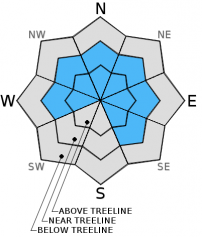
Avalanche Problem 1: Wind Slab
-
Character ?

-
Aspect/Elevation ?
-
Likelihood ?CertainVery LikelyLikelyPossible
 Unlikely
 -
Size ?HistoricVery LargeLargeSmall

Wind deposits have been numerous and southerly winds maintained a strong speed above treeline, efficiently moving the lighter density snow onto leeward aspects. Small to large wind drifts and wind slabs are certain, and will likely be easy to trigger today. Some cracking was observed on exposed convexities near treeline yesterday. Be able to identify where wind loading has taken place. Cornices, blowing snow, wind pillows that are soft to hard in nature are all good signs that wind loading is occurred. Avalanche terrain near and above treeline are the areas of most concern, but do not forget about lower angle run out zones. Even though the terrain under your feet may not be a steep slope, it could be connected to a steep slope and you could be in harms way.
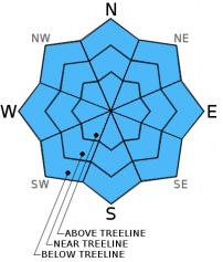
Avalanche Problem 2: Storm Slab
-
Character ?

-
Aspect/Elevation ?
-
Likelihood ?CertainVery LikelyLikelyPossible
Unlikely
-
Size ?HistoricVery LargeLargeSmall
Soft storm slabs that formed from rapid precipitation rates yesterday were relatively unreactive due to the light and dry nature of the snow. Near treeline, in areas that are protected from the wind, will be the best places to find any unstable storm slabs. The cool temperatures from yesterday have been followed by continued cold temperatures today which will help keep things "right side up" from just below to above treeline. Storm slab instabilities may remain, so it will be a good idea to continue to play it safe for today.
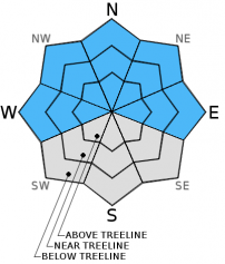
Avalanche Problem 3: Cornice
-
Character ?

-
Aspect/Elevation ?
-
Likelihood ?CertainVery LikelyLikelyPossible
Unlikely
-
Size ?HistoricVery LargeLargeSmall
Cornices that developed over the past several days may be medium to large in size. Any sun exposure, and subsequent warming may add weight and tip the stress scale causing release. The bottom line: stay back, well away from the edge. Identify terra firma like trees or rocks protruding from the snow and keep to those areas. Cornices, small to large, can break and also trigger a slide below. If you're with it, game over.
Forecast Discussion
Yesterday was yet another raucous and rowdy winter romp in and around the Mount Shasta area. According to water measurements in the town of Mt. Shasta, we received 0.82 inches of water. Up at the Old Ski Bowl weather station that water took the form of 14 inches of new snow. By late evening the moon and stars began to appear and temperatures started to drop presenting a short break in the weather. Strong westerly flow and a long wave trough that will pass over the region today will bring a final dose of precipitation. A long wave ridge will begin to build slowly over the Northwest late today, but will amplify with time. Tuesday through the end of the week looks to be sunny with temperatures rising to 5-10 degrees above normal by Thursday and Friday. For today, snow levels will be relatively low reaching down to around 4,000 feet. Winds will be light to moderate coming out of the southwest, then shifting to the west/northwest tonight into tomorrow as high pressure builds.
THIS SEASON PRECIPITATION for MT SHASTA CITY: Since October 1st (the wet season), we have received 35.35 inches of water, normal is 32.59 inches, putting us at 108% of normal. For the month of March we've received 9.83 inches of water, normal is 3.09 inches, putting us at 318% of normal, and finally... for the year of 2016 we've received 25.86 inches of water, normal is 17.38 inches, putting us at 148% of normal .
Recent Observations
The past five days have brought a tremendous amount of snow to the Mt. Shasta area. The snow depth near treeline has reached a whopping 15 feet, with Bunny Flat clocking in at just over 10 feet. Those snow depths will lower some as all the new snow settles down with the warm and sunny weather on the horizon. That being said, reports were made of waste deep snow from both the east side of the forecast area, and the flanks of Mt. Shasta yesterday. We're talking truly waste deep, as in boot penetration waste deep! Snow fell at 2-3 inches per hour yesterday between 10 am and 1 pm, as recorded at the Old Ski Bowl weather station. Those high precipitation rates are a red flag. With all that new snow some avalanche activity would be a sure thing. Evidence of said activity, however, has been hard to find over the past couple of days. A large scale slide that occurred on the SE aspect of Casaval Ridge was observed earlier last week, but with near constant storm activity since then views above treeline have been fleeting. It's likely that some natural avalanche activity occurred immediately during the storm yesterday, and the day before.
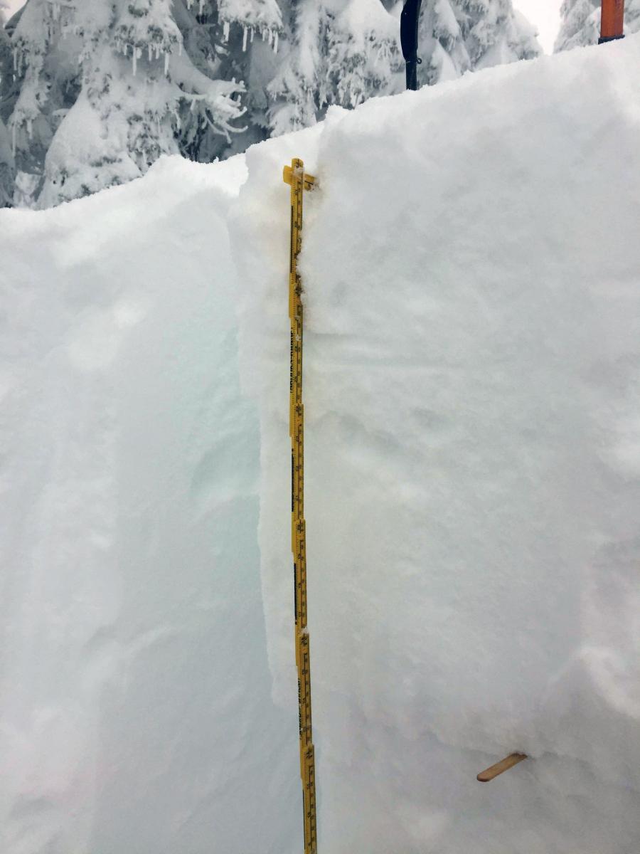
Observations were reported from a volunteer field observer who made a ski tour up Green Butte Ridge yesterday. They were one of only but a few who ventured out into the backcountry with most folks choosing to ride the chair lift at the Mt. Shasta Ski Park. A snow study pit was dug a around 8,000 ft. near treeline on Green Butte Ridge in the "Gerald's Bowl" area. The observer stated that due to the depth and light nature of the new snow he might as well have been using a rake to dig the pit as a shovel. An extended column test was performed resulting in a score of ECTN 14 Q2 at a depth of 49 cm (see photo).
Concern for today will lie in any change of density in the new snow that fell over the past couple of days. Remain wary of avalanche terrain, and use cautious route finding. Evaluate the snowpack and used conservative decision making. Dig a quick pit and perform a stability test or two before committing to a slope. For those slide paths that did not release, today could be the day.
Extended column test from 3-13-2016 performed by Shane Rathbun in the "Gerald's Bowl" vicinity of Green Butte Ridge on a S/SE aspect with a fracture depth of 49 cm:
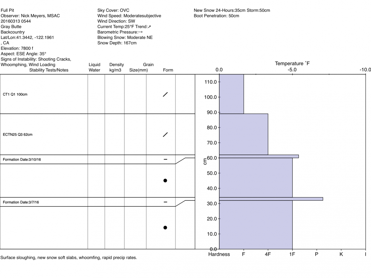
Full Pit profile from 3-12-2016, performed on Gray Butte by Forecaster:
-----------------------------------------------------------------------------------------------------------------------------------------------------------
LOCAL AREA ROAD, NORDIC, AND SNOWMOBILE PARK STATUS:
The Sand Flat cross country ski trails are in good shape and ready for your cross country skis and snow shoes. These are backcountry routes marked with blue diamonds on trees. Trails are not groomed. Snow shoers, please blaze a parallel trail to cross country skiers staying out of the skin track. These trails can be accessed via the Everett Memorial Highway. Thank you, and enjoy!
The Mt. Shasta Nordic Center is open! These beautiful, groomed trails can be accessed via the Ski Park Highway. http://www.mtshastanordic.org
The Pilgrim Creek & Deer Mountain Snowmobile Parks are open! Trails have not been groomed in the past week and a half due to warm temperatures. Head to our "Education" tab on our website and find the snowmobile section for trail information, grooming status, and other sledder resources.
The Castle Lake Road is CLOSED at the gate. The culvert blew out and we do not know when it will be repaired. The Everett Memorial Highway is plowed to Bunny Flat.
The Five Red Flags of Avalanche Danger any time of year include: 1) Recent/current avalanche activity 2) Whumphing sounds or shooting cracks 3) Recent/current heavy snowfall 4) Strong winds transporting snow 5) Rapid warming or rain on snow.
Weather and Current Conditions
Weather Summary
Good Morning! In Mt Shasta City at 0500, we have a current temperature of 33 F, five degrees cooler than yesterday at this time. Skies are overcast with calm wind.
On Mt Shasta (South Side) in the last 24 hours...
Old Ski Bowl - 7,600 feet, the current temperature is 20 degrees F. Snow on the ground totals 180 inches with 14 inches new snow and 1 inch of settlement. Temperatures have ranged from 20 F to 29 F.
Gray Butte - 8,000 feet, the current temperature is 19 degrees F. Temperatures have ranged from 19 F to 28 F. Winds have been southwesterly. The speed sensor heaters are not working and the unit is riming. Current winds speeds are not available. Working on fixing this. Thanks for understanding.
Mt Eddy Range (West side of Interstate-5)...
Castle Lake - 5,600 feet, the current temperature is 25 degrees. Temperatures have ranged from 25 F to 34 F. Snow on the ground totals 92 inches with 6 inches new snow and little settlement.
Mt Eddy - 6,500 feet, the current temperature is 23 degrees F. Temperatures have ranged from 23 F to 31 F. Snow on the ground measures 106 inches with 5 inches new snow and 1 inch of settlement. Winds have been southerly in nature with an average of 2 mph, and a maximum gust of 15 mph, S.
Always check the weather before you attempt to climb Mt Shasta. Further, monitor the weather as you climb. Becoming caught on the mountain in any type of weather can compromise life and limb. Be prepared.
| 0600 temperature: | 25 |
| Max. temperature in the last 24 hours: | 33 |
| Average wind direction during the last 24 hours: | Southerly |
| Average wind speed during the last 24 hours: | n/a mi/hr |
| Maximum wind gust in the last 24 hours: | n/a mi/hr |
| New snowfall in the last 24 hours: | 4 inches |
| Total snow depth: | 123 inches |
Two Day Mountain Weather Forecast
Produced in partnership with the Medford NWS
| For 7000 ft to 9000 ft | |||
|---|---|---|---|
|
Monday (4 a.m. to 10 p.m.) |
Monday Night (10 p.m. to 4 a.m.) |
Tuesday (4 a.m. to 10 p.m.) |
|
| Weather | Mostly cloudy with snow showers | Mostly cloudy with a 30% chance of snow showers, mainly before 11 pm. Blustery | Partly sunny with a 20% chance of snow showers before 11 am. |
| Temperature (°F) | 30 | 21 | 36 |
| Wind (mi/hr) | Southwest 10-15 mph with gusts to 35 mph | West 10-15 mph decreasing to around 5 mph after midnight | Northwest 5-10 mph |
| Precipitation SWE / Snowfall (in) | / 1-3 | / 0-1 | / 0 |
| For 9000 ft to 11000 ft | |||
| Monday | Monday Night | Tuesday | |
| Weather | Mostly cloudy with snow showers. Windy with wind chill values as low as -26 | Mostly cloudy with a 30% chance of snow showers, mainly before 11 pm. Windy with wind chill values as low as -19. | Partly sunny with a 20% chance of snow showers before 11 am. |
| Temperature (°F) | 12 | 12 | 21 |
| Wind (mi/hr) | West 40-45 mph with higher gusts | Northwest 2-4 | Northwest 25-30 mph |
| Precipitation SWE / Snowfall (in) | / 2-4 | / 0-1 | / 0 |

