

You are here
Avalanche Advisory for 2016-03-15 07:00:09
- EXPIRED ON March 16, 2016 @ 7:00 amPublished on March 15, 2016 @ 7:00 am
- Issued by Jon Dove - Shasta-Trinity National Forest
Bottom Line
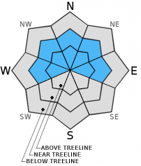
MODERATE avalanche danger exists near and above treeline for remaining wind slabs on W-NW-N-NE-E aspects. Some isolated storm slabs may remain at higher elevations. LOW danger will be found below treeline on all aspects. Human trigger of lingering wind slabs may be possible on slopes 37 degrees and steeper. Loose wet snow instabilities may develop on southerly aspects, but are unlikely. Continue to evaluate the snow carefully and identify features of concern. Use caution on steeper slopes.


Avalanche Problem 1: Wind Slab
-
Character ?

-
Aspect/Elevation ?
-
Likelihood ?CertainVery LikelyLikelyPossible
 Unlikely
 -
Size ?HistoricVery LargeLargeSmall

Wind slab formations were found yesterday on leeward NW-N-NE aspects with cross loading evident on W and E aspects. Medium to small lingering wind drifts and wind slabs may still be possible to trigger today. Try to identify where wind loading has taken place by looking for remaining cornices, wind pillows that are soft to hard in nature, and other wind formations such as ribs behind trees. These are all good signs that wind loading is occurred. Slopes 37 degrees and steeper near and above treeline on leeward aspects are the areas of most concern for today.
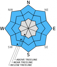
Avalanche Problem 2: Loose Wet
-
Character ?

-
Aspect/Elevation ?
-
Likelihood ?CertainVery LikelyLikelyPossible
Unlikely
-
Size ?HistoricVery LargeLargeSmall
Loose wet snow instabilities such as roller balls, pinwheels, and point release loose wet avalanches will be possible as temeratures increase and the sun bakes southerly facing aspects. Some clouds today and the mild temperatures will prevent said instabilities from occurring. However, over the coming days this avalanche problem will become more of a concern, especially on Thursday and Friday.
Forecast Discussion
Our first of several days of sunshine finally revealed mountains of white surrounding Mount Shasta City yesterday. Mostly clear skies in the morning did give way to some clouds with a snowflake or two around some of the higher points in the forecast area in the afternoon, however. Sunshine and warming temperatures will characterize the remainder of the work week as a ridge of high pressure builds over the area. This will last into early next weekend. By Sunday weather models are in "pretty good agreement the pattern will turn wet again, and remains wet and unsettled into early next week." The sunshine and warmth will continue to settle and consolidate all the new snow that we have received over the past several days. Northwest winds will be light at most elevations with ridge top winds above 10,000 feet reaching 15-20 mph today, then decreasing tomorrow to around 10 mph. Temperatures rise on Thursday and Friday with daytime highs reaching 32 degrees at 10,000-11,000 feet. Temperatures at treeline will be flirting with 50 degrees. Despite the "spring like" conditions, do not expect corn snow to develop until maybe Friday. Maybe...
THIS SEASON PRECIPITATION for MT SHASTA CITY: Since October 1st (the wet season), we have received 35.35 inches of water, normal is 32.80 inches, putting us at 107% of normal. For the month of March we've received 9.83 inches of water, normal is 3.30 inches, putting us at 297% of normal, and finally... for the year of 2016 we've received 25.86 inches of water, normal is 17.59 inches, putting us at 147% of normal .
Recent Observations
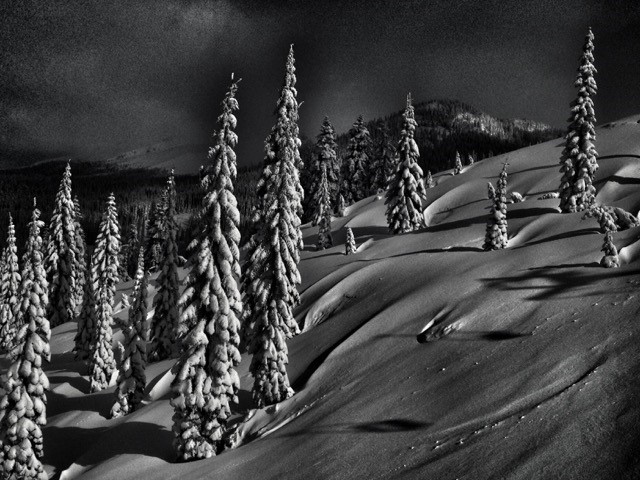
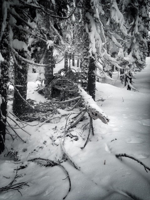
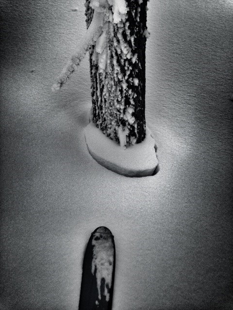
The constant stormy weather that has graced our hills with a veil of white came to an end, and the clouds parted letting some sun shine in. A few clouds did linger in the afternoon hours crowding around the higher points in the forecast area. They too took their leave allowing for some alpenglow to paint Mt. Shasta for a brief period before dark. Some warming late Sunday, then again yesterday caused widespread settling of the snowpack made evident by an apron of snow that clung to the trunks of trees as the surrounding snow sank a few inches (see photo below). Other observations made yesterday on a ski tour up Gray Butte via the Mt. Shasta Ski Park revealed a variety of clues as to the current nature of the snowpack. Below 6,500 feet the snow presented a kind of semi-hard wind buffed crust on the snow that was at some points breakable. South to Southeast aspects had been punished by the strong southerly winds. Evidence of the wind's ferocity was also highlighted by several broken tree tops littering the forest floor (see photo).
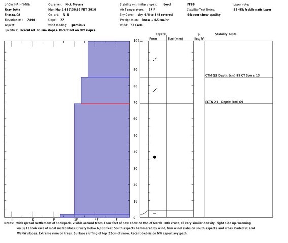
Above 6,500 feet the snow change considerably presenting lighter, and softer conditions. Medium to hard wind slabs were found on several aspects. Cross loading was evident on W and more E facing slopes, as well as the NW aspect of Gray Butte where wind loading is common. Wind loading and the subsequent slabs will also be found on N-NE aspects. A snow study pit was dug on Gray Butte on a more Northwesterly facing aspect at close to 7,800 feet. Four feet of new snow rested on top of the March 10th crust and was "right side up" being fairly uniform one finger density throughout. It was slightly less dense just near the surface. An extended column test resulted in a score of ECTN 21 with poor shear quality at 69 cm deep.
Avalanche concerns for today will be for remaining wind slab instabilities on leeward W-NW-N-NE-E aspects on slopes 37 degrees and steeper near and above treeline. You may find loose dry sloughing snow on steep shaded Northerly facing aspects, but they will be small and likely very inconsequential. Loose wet snow instabilities will become more of a problem as the week progresses and temperatures warm up. Continue to practice safe travel techniques and be sure to evaluate the snow and terrain before committing to a slope.
Pit profile performed on Gray Butte 3-14-2016 by Nick Meyers:
Wind ribs behind trees from S/SW winds, 6,600 feet near Gray Butte (MS Ski Park):
Several tree tops freshly broken due to strong southerly winds during this past weekend storms (Gray Butte):
Widespread settlement of snowpack visible around all trees:
-----------------------------------------------------------------------------------------------------------------------------------------------------------
LOCAL AREA ROAD, NORDIC, AND SNOWMOBILE PARK STATUS:
The Sand Flat cross country ski trails are in good shape and ready for your cross country skis and snow shoes. These are backcountry routes marked with blue diamonds on trees. Trails are not groomed. Snow shoers, please blaze a parallel trail to cross country skiers staying out of the skin track. These trails can be accessed via the Everett Memorial Highway. Thank you, and enjoy!
The Mt. Shasta Nordic Center is open! These beautiful, groomed trails can be accessed via the Ski Park Highway. http://www.mtshastanordic.org
The Pilgrim Creek & Deer Mountain Snowmobile Parks are open! Trails have not been groomed in the past week and a half due to constant deep snow fall. Head to our "Education" tab on our website and find the snowmobile section for trail information, grooming status, and other sledder resources.
The Castle Lake Road is CLOSED at the gate. The culvert blew out and we do not know when it will be repaired. The Everett Memorial Highway is plowed to Bunny Flat and currently mostly snow free until about Red Fir Flat up.
The Five Red Flags of Avalanche Danger any time of year include: 1) Recent/current avalanche activity 2) Whumphing sounds or shooting cracks 3) Recent/current heavy snowfall 4) Strong winds transporting snow 5) Rapid warming or rain on snow.
Weather and Current Conditions
Weather Summary
Good Morning! In Mt Shasta City at 0500, we have a current temperature of 33 F, the same yesterday at this time. Skies are overcast with calm wind.
On Mt Shasta (South Side) in the last 24 hours...
Old Ski Bowl - 7,600 feet, the current temperature is 23 degrees F. Snow on the ground totals 175 inches with no new snow and 5 inches of settlement. Temperatures have ranged from 17 F to 27 F.
Gray Butte - 8,000 feet, the current temperature is 17 degrees F. Temperatures have ranged from 15 F to 27 F. Winds have been west/northwest in direction. The speed sensor heaters are not working and the unit is riming. Current winds speeds are not available. Working on fixing this. Thanks for understanding.
Mt Eddy Range (West side of Interstate-5)...
Castle Lake - 5,600 feet, the current temperature is 24 degrees. Temperatures have ranged from 22 F to 42 F. Snow on the ground totals 89 inches with no new snow and 3 inches of settlement.
Mt Eddy - 6,500 feet, the current temperature is 23 degrees F. Temperatures have ranged from 19 F to 30 F. Snow on the ground measures 103 inches with no new snow and 3 inches of settlement. Winds have been variable in nature with an average of 2 mph, and a maximum gust of 13 mph, SE.
Always check the weather before you attempt to climb Mt Shasta. Further, monitor the weather as you climb. Becoming caught on the mountain in any type of weather can compromise life and limb. Be prepared.
| 0600 temperature: | 23 |
| Max. temperature in the last 24 hours: | 33 |
| Average wind direction during the last 24 hours: | West/northwest |
| Average wind speed during the last 24 hours: | n/a mi/hr |
| Maximum wind gust in the last 24 hours: | n/a mi/hr |
| New snowfall in the last 24 hours: | 0 inches |
| Total snow depth: | 120 inches |
Two Day Mountain Weather Forecast
Produced in partnership with the Medford NWS
| For 7000 ft to 9000 ft | |||
|---|---|---|---|
|
Tuesday (4 a.m. to 10 p.m.) |
Tuesday Night (10 p.m. to 4 a.m.) |
Wednesday (4 a.m. to 10 p.m.) |
|
| Weather | Partly sunny | Partly cloudy | Sunny |
| Temperature (°F) | 38 | 28 | 45 |
| Wind (mi/hr) | Northwest 5-10 mph | North/northwest Around 5 mph | Northeast 5-10 mph |
| Precipitation SWE / Snowfall (in) | / 0 | / 0 | / 0 |
| For 9000 ft to 11000 ft | |||
| Tuesday | Tuesday Night | Wednesday | |
| Weather | Mostly sunny with wind chill values as low as zero | Partly cloudy | Sunny |
| Temperature (°F) | 22 | 22 | 27 |
| Wind (mi/hr) | Northwest 15-20 mph | Northwest 0 | Northwest 5-10 mph |
| Precipitation SWE / Snowfall (in) | / 0 | / 0 | / 0 |

