

You are here
Avalanche Advisory for 2016-03-17 07:02:05
- EXPIRED ON March 18, 2016 @ 7:02 amPublished on March 17, 2016 @ 7:02 am
- Issued by Nick Meyers - Shasta-Trinity National Forest
Bottom Line
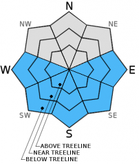
Overall, LOW avalanche danger will be found in the forecast area today. As daytime warming occurs, expect pockets of MODERATE danger on E-SE-S-SW-W aspects, all elevations, due to wet-loose instabilities.
Lingering pockets of MODERATE danger for a human triggered wind slab is possible on steep W-NW-N-NE-E facing slopes, near and above treeline.
As always, continue to use safe travel practices and evaluate slopes carefully before committing.


Avalanche Problem 1: Loose Wet
-
Character ?

-
Aspect/Elevation ?
-
Likelihood ?CertainVery LikelyLikelyPossible
 Unlikely
 -
Size ?HistoricVery LargeLargeSmall

Loose wet snow instabilities such as roller balls, pinwheels, and point release loose wet avalanches are likely today as temeratures increase and the sun bakes southerly facing aspects. Gradual warming, with today being the warmest day of the week, could cause unconsolidated new snow to begin to produce roller balls and donut rolls. These are signs that larger loose wet point releases are possible. While much of the time these types of avalanches are not an immediate threat to life, they certainly could sweep you into undesireable terrain. Mt Shasta is capable of producing large loose wet slides and we are getting into the time of the year when they become a real possibility.
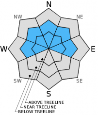
Avalanche Problem 2: Wind Slab
-
Character ?

-
Aspect/Elevation ?
-
Likelihood ?CertainVery LikelyLikelyPossible
Unlikely
-
Size ?HistoricVery LargeLargeSmall
Naturally triggered wind slabs have occured over the weekend, however several days of sun and settlement in the snowpack have allowed wind slabs to gain strength. Gale force winds out of the south loaded NW-N-NE slopes and cross loaded westerly and easterly aspects. Windward slopes are scoured down to crust or hard, wind packed sastrugi features. Very little existing snow remains for new wind transport, however remaining wind slabs on steep slopes could still be reactive and human triggering remains possible. Try to identify where wind loading has taken place by looking for remaining cornices, wind pillows that are soft to hard in nature, and other wind formations such as ribs behind trees. These are all good signs that wind loading is occurred. Slopes 37 degrees and steeper near and above treeline on leeward aspects are the areas of most concern for today. Some cornices also remain along ridgelines from the strong southerly winds. These could break off and potentially trigger a slide below. Stay back on terra firma!
Forecast Discussion
More beautiful, warm weather, which may cause recreational stress in some, will dominate the landscape today. If you got out yesterday, you certainly could not help but feel a touch of Spring in the air. That will be the case again today. The warmest day of the week, today temps are already recording several degrees above yesterday at this time. This is good for the those deficient in Vitamin D or others tired of WInter. The gorgeous weather will continue for the remainder of the week...the weekend will bring our next stormy pattern.... a reluctant system will move through on Saturday before a stronger and wetter system arrives Sunday. This wet period should last at least through the middle of next week... so, perhaps a little more Winter for the region still.
THIS SEASON PRECIPITATION for MT SHASTA CITY: Since October 1st (the wet season), we have received 35.35 inches of water, normal is 33.20 inches, putting us at 106% of normal. For the month of March we've received 9.83 inches of water, normal is 3.7 inches, putting us at 265% of normal, and finally... for the year of 2016 we've received 25.86 inches of water, normal is 17.99 inches, putting us at 143% of normal .
Recent Observations
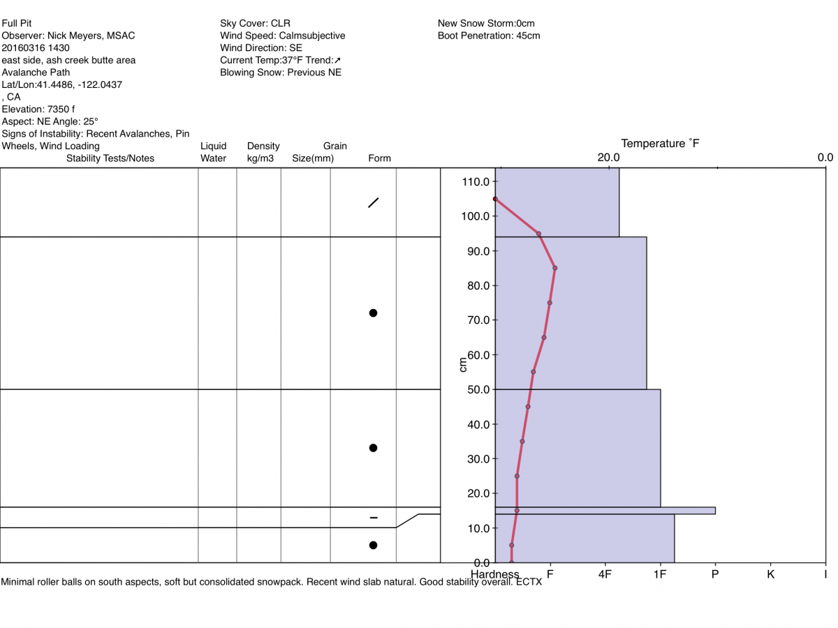
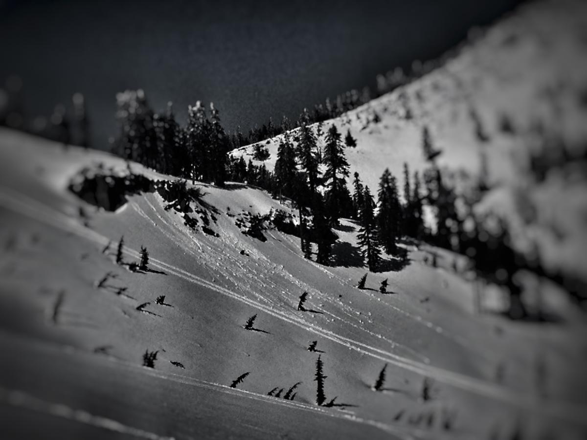
Another beautiful day yesterday. Temperatures are already several degrees warmer than yesterday at this time. Today will be the warmest day of the week and will present the best chance of loose-wet related instabilities. A good tour of the East side of the forecast area yesterday revealed much of the same... The four feet of fresh snow that fell over this past weekend continues to consolidate (another 3.5 inches at the Old Ski Bowl) and overall good stability found. Evidence of avalanche debris and old crown lines from the past week are still being observed in the forecast area. A northeast facing, wind loaded ridgeline was naturally triggered at some point during or after the storm. (see photo below) Also observed in the past few days was debris in avalanche paths on the east/southeast and northwest sides of Gray Butte. Some minimal roller balls were observed on warm, southerly slopes. We will likely see more roller ball, loose-wet related action today.
The snowpack is variable and in a transitional state and will remain so for the week likely. Mt Shasta's famous spring corn just doesn't happen overnight! The aspect and elevation you choose will be important if you hope to find good snow today! Below 6,500 feet, sourtherly facing slopes are firm, crusty and somewhat supportable. Some northerly aspects below this elevation hold some decent thick powder. As one gains elevation and approaches near and above treeline areas, the snow does get better but variable will be the word of the day. Southerly aspects remain wind hammered. Strong southerly winds punished south aspects as well as cross loaded some West and East aspects. Sastrugi features and wind buffed snow is most common above treeline. Below and near treeline, many broken tree tops littering the forest floor have been observed over the forecast area. Some have been finding smooth, soft snow above 6,500 feet, however surface conditions of the snow may be funky here and there. Did I mention variable?
Avalanche concerns for today will be low for any potentially unstable wind slabs on leeward W-NW-N-NE-E aspects, slopes 37 degrees and steeper near and above treeline. You may find loose dry sloughing snow on steep, shaded Northerly facing aspects, but they will be small and likely very inconsequential. Loose wet snow instabilities are likely today as it's the warmest day of the week. Continue to practice safe travel techniques and be sure to evaluate the snow and terrain before committing to a slope.
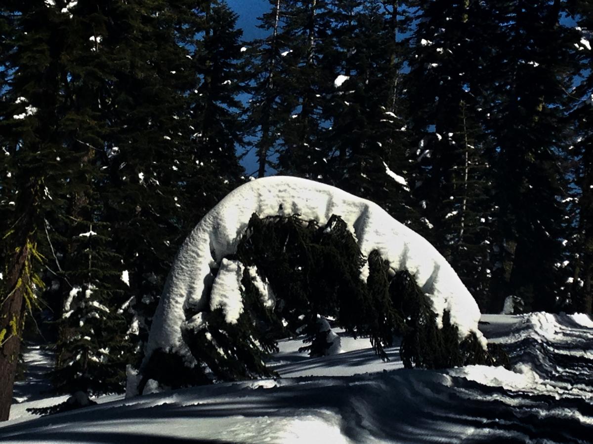
Left: Minimal roller balls observed on southerly aspects, 3.16.16 / Right: Heavy snow!
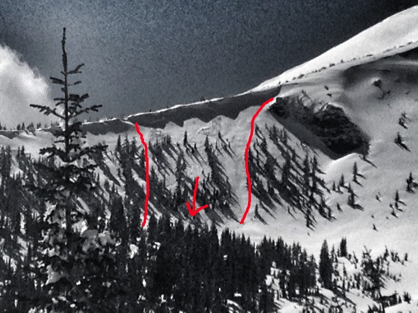
Naturally occuring slide on a Northeast facing, wind loaded aspect, East side, observed 3.16.16
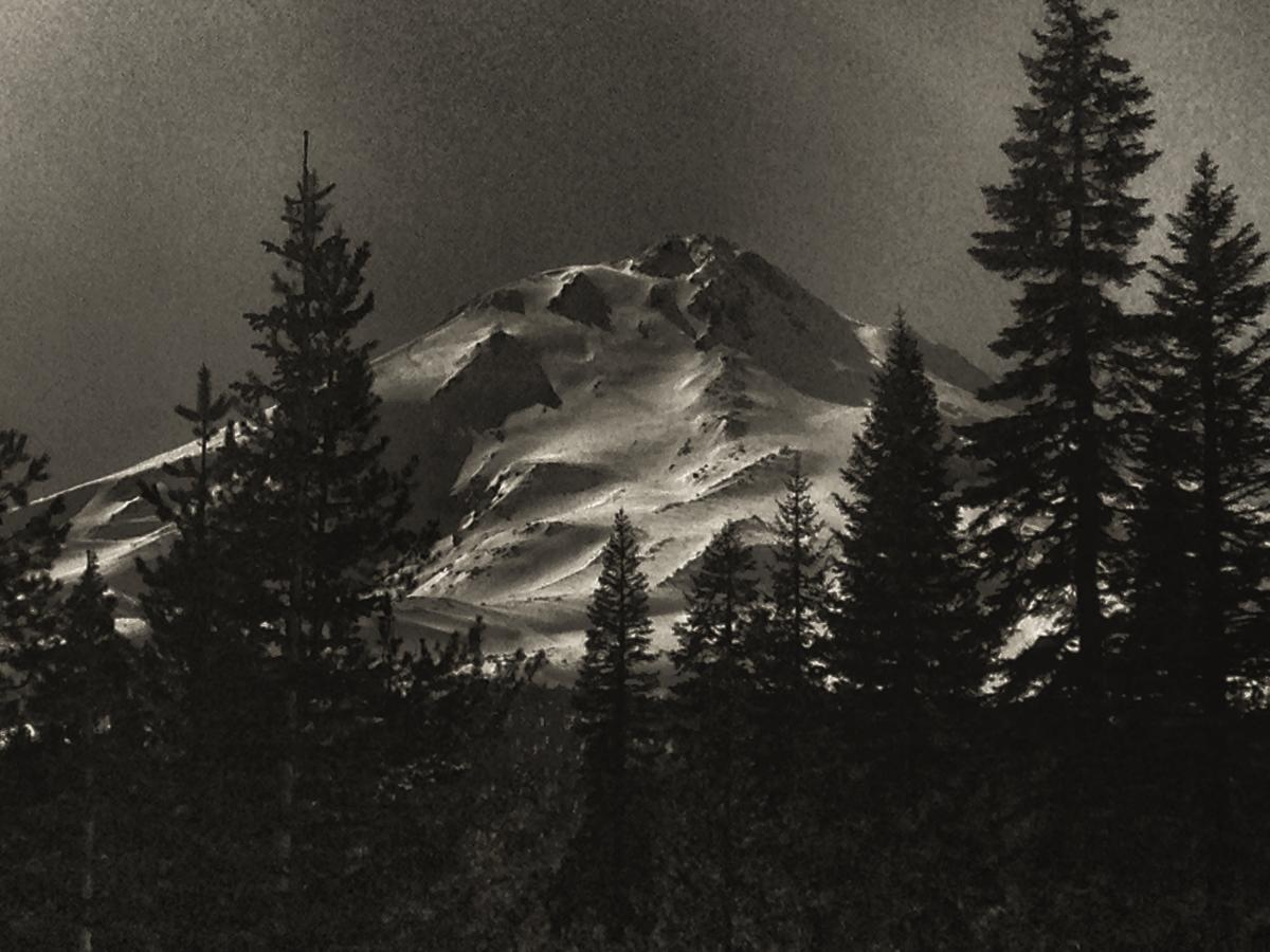
Hey all you East side lovers! Here is a sneak peak at what's in store for this Spring! The Hotlum/Wintun Route in view. 3.16.16
-----------------------------------------------------------------------------------------------------------------------------------------------------------
LOCAL AREA ROAD, NORDIC, AND SNOWMOBILE PARK STATUS:
The Sand Flat cross country ski trails are in good shape and ready for your cross country skis and snow shoes. These are backcountry routes marked with blue diamonds on trees. Trails are not groomed. Snow shoers, please blaze a parallel trail to cross country skiers staying out of the skin track. These trails can be accessed via the Everett Memorial Highway. Thank you, and enjoy!
The Mt. Shasta Nordic Center is open! These beautiful, groomed trails can be accessed via the Ski Park Highway. http://www.mtshastanordic.org
The Pilgrim Creek & Deer Mountain Snowmobile Parks are open! Trails have not been groomed in the past week and a half due to constant deep snow fall. Head to our "Education" tab on our website and find the snowmobile section for trail information, grooming status, and other sledder resources.
The Castle Lake Road is CLOSED at the gate. The culvert blew out and we do not know when it will be repaired. The Everett Memorial Highway is plowed to Bunny Flat and currently mostly snow free until about Red Fir Flat up.
The Five Red Flags of Avalanche Danger any time of year include: 1) Recent/current avalanche activity 2) Whumphing sounds or shooting cracks 3) Recent/current heavy snowfall 4) Strong winds transporting snow 5) Rapid warming or rain on snow.
Weather and Current Conditions
Weather Summary
Good Morning! In Mt Shasta City at 0500, we have a current temperature of 34 F, four degrees warmer than yesterday at this time. Skies are mostly clear with calm wind.
On Mt Shasta (South Side) in the last 24 hours...
Old Ski Bowl - 7,600 feet, the current temperature is 34 degrees F. Snow on the ground totals 168 inches with no new snow and 3.5 inches of settlement. Temperatures have ranged from 26 F to 48 F.
Gray Butte - 8,000 feet, the current temperature is 35 degrees F. Temperatures have ranged from 27 F to 38 F. Winds have been variable in direction averaging 4-6 mph with a gust to 21, NNW.
Mt Eddy Range (West side of Interstate-5)...
Castle Lake - 5,600 feet, the current temperature is 38 degrees. Temperatures have ranged from 30 F to 50 F. Snow on the ground totals 85 inches with no new snow and 2 inches of settlement.
Mt Eddy - 6,500 feet, the current temperature is 34 degrees F. Temperatures have ranged from 31 F to 43 F. Snow on the ground measures 98 inches with no new snow and 4 inches of settlement. Winds have been southerly in nature with an average of 2 mph, and a maximum gust of 8 mph, SE.
Always check the weather before you attempt to climb Mt Shasta. Further, monitor the weather as you climb. Becoming caught on the mountain in any type of weather can compromise life and limb. Be prepared.
| 0600 temperature: | 28 |
| Max. temperature in the last 24 hours: | 51 |
| Average wind direction during the last 24 hours: | Variable |
| Average wind speed during the last 24 hours: | 4-6 mi/hr |
| Maximum wind gust in the last 24 hours: | 21 (Gray Butte) mi/hr |
| New snowfall in the last 24 hours: | 0 inches |
| Total snow depth: | 113 inches |
Two Day Mountain Weather Forecast
Produced in partnership with the Medford NWS
| For 7000 ft to 9000 ft | |||
|---|---|---|---|
|
Thursday (4 a.m. to 10 p.m.) |
Thursday Night (10 p.m. to 4 a.m.) |
Friday (4 a.m. to 10 p.m.) |
|
| Weather | Sunny, with a high near 54. North northeast wind 5 to 10 mph becoming calm in the afternoon. | Clear, with a low around 38. Calm wind becoming south southeast 5 to 10 mph after midnight. | Sunny, with a high near 52. South wind 5 to 15 mph, with gusts as high as 20 mph. |
| Temperature (°F) | 54 | 38 | 52 |
| Wind (mi/hr) | North/Northeast 5-10 mph | South/southeast 5-10 mph | South 5-15 mph |
| Precipitation SWE / Snowfall (in) | / 0 | / 0 | / 0 |
| For 9000 ft to 11000 ft | |||
| Thursday | Thursday Night | Friday | |
| Weather | Sunny, with a high near 33. North wind 5 to 10 mph. | Clear, with a low around 31. West northwest wind 5 to 10 mph. | Sunny, with a high near 31. South southwest wind 5 to 15 mph, with gusts as high as 25 mph. |
| Temperature (°F) | 33 | 31 | 31 |
| Wind (mi/hr) | North 5-10 mph | West/Northwest 0 | South/Southwest 5-15 mph |
| Precipitation SWE / Snowfall (in) | / 0 | / 0 | / 0 |

