

You are here
Avalanche Advisory for 2016-03-21 07:02:48
- EXPIRED ON March 22, 2016 @ 7:02 amPublished on March 21, 2016 @ 7:02 am
- Issued by Jon Dove - Shasta-Trinity National Forest
Bottom Line
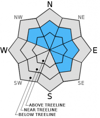
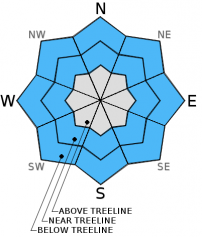
Overall, MODERATE avalanche danger exists on all aspects and elevaitons, slopes 35 degrees and steeper for newly forming storm and wind slabs. Storm slabs will be most prevalent near and below treeline as strong southerly winds limit development above. Pockets of CONSIDERABLE danger may develop on wind loaded, leeward NW-N-NE-E-SE aspects near and above treeline. Human trigger of said problems is possible. Careful snowpack and terrain evaluation necessary. Conservative decision making advised.


Avalanche Problem 1: Wind Slab
-
Character ?

-
Aspect/Elevation ?
-
Likelihood ?CertainVery LikelyLikelyPossible
 Unlikely
 -
Size ?HistoricVery LargeLargeSmall

Wind slabs will continue to develop, and be a concern for backcountry travelers today near and above treeline. New snow amounts of 12-14 inches are predicted with today's storm. That will make for plenty of loose snow to be transported by the strong southerly winds associated with this storm. Wind slabs could build to be 2 feet or more in thickness. These will be sensitive to human trigger as they build, and immediately after the storm subsides. They will be found on wind loaded, leeward NW-N-NE-E-SE aspects in the typical starting zones along ridge tops, around rock outcroppings, the tops of chutes and couloirs, and gullies. Due to the strong nature of the winds, slabs may develop in non-typical ares such as mid-slope depressions, or along the leeward sides of moraines. Poor visibility and the high wind will prevent folks from pushing above treeline today, but wind slabs will be present near treeline as well. Use caution in choosing you route of travel. Evaluate the snow and terrain carefully before committing to a path.
Avalanche Problem 2: Storm Slab
-
Character ?

-
Aspect/Elevation ?
-
Likelihood ?CertainVery LikelyLikelyPossible
Unlikely
-
Size ?HistoricVery LargeLargeSmall
Water amounts of around 1 inch are predicted with today's storm, and snow levels will be relatively low. That means that up to a foot of new snow is in store, and the potential for storm slab formation is on the rise. Yesterday's storm brought snow down to around 6,300 feet, but it was wet and heavy keeping snow accumulation to only an inch or two with some settlement near and below treeline. Today's storm is colder and snow levels have dropped to between 4,000-5,000 feet making storm slab development likely near and below treeline. Strong southerly winds will limit storm slabs from building above treeline. Overall, the snow has come in with a "right side up" nature and the wet snow at the interface with the new will help with bonding. That being said, slopes 35 degrees and steeper could produce a slab avalanche later today as snow accumulations reach their maximum. Some human triggered loose dry sloughing of snow may be possible late today and early tomorrow, as well.
Forecast Discussion
Steady rain yesterday delivered close to the 0.7 inches of water forecast for depending on where you look. Sand Flat weather station recorded 0.88 inches of water, where as Mt. Shasta City recorded 0.54 inches of water. The rain subsided, and the clouds parted in the late afternoon allowing the sun shine through to finish the day. The break between storms is over and light to moderate precipitation is currently falling. Wind advisories are in place as southerly winds increase ahead of the cold front that is moving on shore this morning. An unstable atmosphere will bring a chance of some thunder with today's system, as well. It's looking like we have the makings of a proper spring storm. Water amounts associated with this system are predicted to reach just over 1 inch of water by early Tuesday. As for snow levels, they look to be hovering between 4,000-5,000 feet for today, then lowering to around 3,500 by early Tuesday. We could see a snow flake or two in Mt. Shasta City by then. Elevations above 6,000 feet could receive a solid foot of snow or more when all the shots are fired. Strong south/southwest winds will build wind slabs near and above treeline. Storm slabs may be an issue near and below treeline as well, so don't hang up your avy awareness cap just yet. Pay attention to the terrain and the new snow when you're out enjoying some good spring powder.
THIS SEASON PRECIPITATION for MT SHASTA CITY: Since October 1st (the wet season), we have received 35.84 inches of water, normal is 33.88 inches, putting us at 105% of normal. For the month of March we've received 10.32 inches of water, normal is 4.38 inches, putting us at 235% of normal, and finally... for the year of 2016 we've received 26.35 inches of water, normal is 18.67 inches, putting us at 141% of normal.
Recent Observations
Observations from the backcountry yesterday are limited. Snow was falling from around 6,000 feet and up with yesterday's storm, but was not sticking and accumulating until one got above 6,300 feet. New snow of around 1-2 inches accumulated at Bunny Flat. It was quickly settled down, however, by it's wet and heavy nature and the sun that followed in the late afternoon. The skies cleared just before dark allowing things to cool off considerably by nightfall. The current storm began to produce precipitation early this morning at around 3 am. Water amounts of just over 1 inch area predicted by early Tuesday. Snow levels with be around 4,500 feet and will drop to around 3,500 feet by late tonight into early tomorrow morning. New snow amounts could total a foot or more when all is said and done. Considering the low snow levels storm slab development is likely near and below treeline. The strong nature of the southerly winds accompanying this system will keep storm slab development above treeline to a minimum. The main concern for near and above treeline will be new, and continued wind slab formations. Wind slabs of up to 2+ feet thick will be likely. Human trigger of these slabs will be possible. Backcountry travel above treeline will be limited today due to the strong winds and poor visibility, but significant wind slab development will occur near treeline as well. Careful evaluation of the snowpack and terrain should be made, especially later today as new snow accumulates. Be conservative with your decision making when choosing your route, and plan of descent. Slopes of 35 degrees and steeper, and wind loaded leeward NW-N-NE-E-SE aspects will be the most likely to produce an avalanche today.
A note for all climbers and skiers heading up onto the upper mountain: Rime ice has formed on most rock outcroppings and is currently very thick. As warm days ensue, rime ice will flake off and fall down onto the slopes below. Rime ice chunks can be very large and very hard, enough to potentially kill you or cause serious injury. Beware of this hazard.
LEFT: Wild, wind sculpted snow on top of Green Butte, South side, Mt Shasta on 3.19.16. Wind features like this can be found throughout the forecast area. RIGHT: Widespread melt runnels, 3.19.16
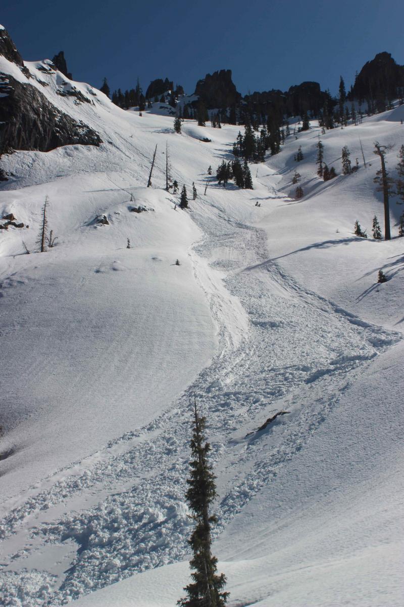
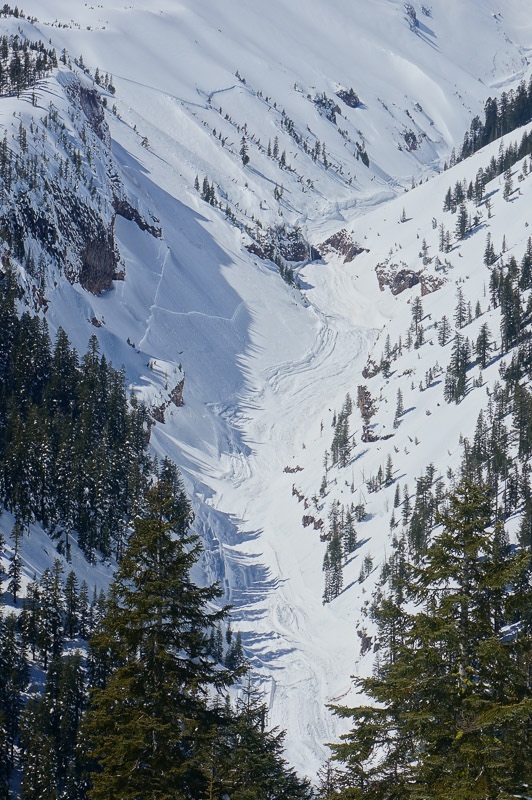
LEFT: Loose-wet slide observed under Castle Spire, Castle Lake area on 3.18.16, photo: O. Stroud - RIGHT: Slab avalanche in Mud Creek Canyon observed 3.17.16, photo: G. Kallio
-----------------------------------------------------------------------------------------------------------------------------------------------------------
LOCAL AREA ROAD, NORDIC, AND SNOWMOBILE PARK STATUS:
The Sand Flat cross country ski trails are in good shape and ready for your cross country skis and snow shoes. These are backcountry routes marked with blue diamonds on trees. Trails are not groomed. Snow shoers, please blaze a parallel trail to cross country skiers staying out of the skin track. These trails can be accessed via the Everett Memorial Highway. Thank you, and enjoy!
The Mt. Shasta Nordic Center is open! These beautiful, groomed trails can be accessed via the Ski Park Highway. http://www.mtshastanordic.org
The Pilgrim Creek & Deer Mountain Snowmobile Parks are open! Trails have not been groomed in the past week and a half due to constant deep snow fall. Head to our "Education" tab on our website and find the snowmobile section for trail information, grooming status, and other sledder resources.
The Castle Lake Road is OPEN. The Everett Memorial Highway is plowed to Bunny Flat and currently mostly snow free until about Red Fir Flat up.
The Five Red Flags of Avalanche Danger any time of year include: 1) Recent/current avalanche activity 2) Whumphing sounds or shooting cracks 3) Recent/current heavy snowfall 4) Strong winds transporting snow 5) Rapid warming or rain on snow.
Weather and Current Conditions
Weather Summary
Good Morning! In Mt Shasta City at 0500, we have a current temperature of 39 F, 11 degrees cooler than yesterday at this time. Skies are cloudy with light wind and moderate rain.
On Mt Shasta (South Side) in the last 24 hours...
Old Ski Bowl - 7,600 feet, the current temperature is 23 degrees F. Snow on the ground totals 156 inches with 1 inch of new snow and 1 inch of settlement. Temperatures have ranged from 23 F to 34 F.
Gray Butte - 8,000 feet, the current temperature is 22 degrees F. Temperatures have ranged from 22 F to 33 F. Winds were southerly yesterday till mid afternoon, then switched to more westerly, averaging 15-20 mph with a gust to 56 mph out of the west/northwest.
Mt Eddy Range (West side of Interstate-5)...
Castle Lake - 5,600 feet, the current temperature is 30 degrees F. Temperatures have ranged from 28 F to 40 F. Snow on the ground totals 73 inches with a trace of new snow and little settlement.
Mt Eddy - 6,500 feet, the current temperature is 27 degrees F. Temperatures have ranged from 27 F to 36 F. Snow on the ground measures 89 inches with 2 inches of new snow and little settlement. Winds have been southerly in nature with an average of 2 mph, and a maximum gust of 17 mph, S.
Always check the weather before you attempt to climb Mt Shasta. Further, monitor the weather as you climb. Becoming caught on the mountain in any type of weather can compromise life and limb. Be prepared.
| 0600 temperature: | 28 |
| Max. temperature in the last 24 hours: | 37 |
| Average wind direction during the last 24 hours: | S->WNW->WSW |
| Average wind speed during the last 24 hours: | 15-20 mi/hr |
| Maximum wind gust in the last 24 hours: | 56 (Gray Butte) mi/hr |
| New snowfall in the last 24 hours: | 1 inches |
| Total snow depth: | 101 inches |
Two Day Mountain Weather Forecast
Produced in partnership with the Medford NWS
| For 7000 ft to 9000 ft | |||
|---|---|---|---|
|
Monday (4 a.m. to 10 p.m.) |
Monday Night (10 p.m. to 4 a.m.) |
Tuesday (4 a.m. to 10 p.m.) |
|
| Weather | Snow this morning, then snow and isolated thunderstorms this afternoon. Snow could be heavy at times. Breezy. | Snow showers. | Mostly cloudy with snow showers likely. Chance of precipitation 70%. |
| Temperature (°F) | 27 | 18 | 22 |
| Wind (mi/hr) | South 20-30 mph with gusts to around 50 mph | Southwest 10-15 mph | West 10-15 |
| Precipitation SWE / Snowfall (in) | / 14-20 | / 3-7 | / 2-4 |
| For 9000 ft to 11000 ft | |||
| Monday | Monday Night | Tuesday | |
| Weather | Snow. Snow could be heavy at times. Some thunder is also possible. Windy with wind chill values as low as -15. | Snow showers. Windy with wind chill values as low as -18. | Mostly cloudy with snow showers likely. Chance of precipitation is 60%. Windy with wind chill values as low as -18. |
| Temperature (°F) | 17 | 8 | 10 |
| Wind (mi/hr) | Southwest 50-55 mph with gusts to 65 mph | West 14-20 | West 30-35 mph |
| Precipitation SWE / Snowfall (in) | / 14-20 | / 3-7 | / 2-4 |

