

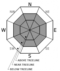
You are here
Avalanche Advisory for 2016-12-01 06:59:14
- EXPIRED ON December 2, 2016 @ 6:59 amPublished on December 1, 2016 @ 6:59 am
- Issued by Nick Meyers - Shasta-Trinity National Forest
Bottom Line
LOW avalanche danger prevails for all aspects and elevations in the forecast area. An isolated, small and stubborn to trigger wind slab could potentially be encountered near and above treeline along a ridgeline, chute, convexity or rock outcrop. Overall, normal caution is advised for travel on Mt Shasta. Watch out for shallow buried objects in other locations within the forecast area, west of I-5.


Avalanche Problem 1: Wind Slab
-
Character ?

-
Aspect/Elevation ?
-
Likelihood ?CertainVery LikelyLikelyPossible
 Unlikely
 -
Size ?HistoricVery LargeLargeSmall

The chance of triggering a wind slab is unlikely today. That said, keep your eye's open for small areas that may host dome shaped, hollow sounding, hard wind deposited snow. Normal caution is advised.
Forecast Discussion
Contrary to several past seasons, Mt. Shasta has been blessed with an early winter with many folks already carrying a dozen or more days of skiing and riding under their belt! A few local folks set their skis on snow as early as October 17th! Yee-haw! It's safe to say that we all hope that Ma Nature keeps it up. Early season conditions below treeline were dicey as usual, however above treeline conditions were quite nice given the time of year. About mid-month in November, more significant snow began to fall on the mountain and below treeline terrain started to shape up, bringing us to our current state of affairs. Aside from Mt Shasta itself, much of the forecast area still has a fairly shallow snowpack. A few folks have been sliding around up in the Castle Lake area, however only 17 inches is on the ground at the Castle weather station. Up in Wagon Bowl on Mt Eddy, 21 inches of snow is on the ground. No reports of skiing/snow conditions up there yet.
Recent Observations
On the mountain, winter is in full stride. West/Northwest winds have been blowing on the mountain over the month of November with several wind events transporting a lot of snow on to south and east aspects. Two good sized wind slab avalanches started off the season right around November 21st off of Green Butte in the Old Ski Bowl. This certainly got my attention and was a great reminder that as long as there is snow on the ground, avalanches can occur, regardless of time of year.
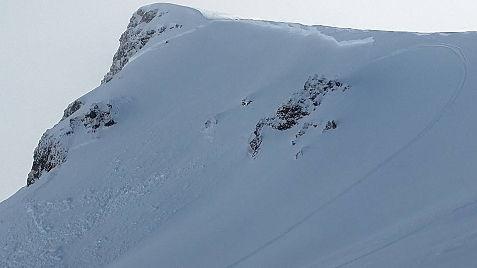
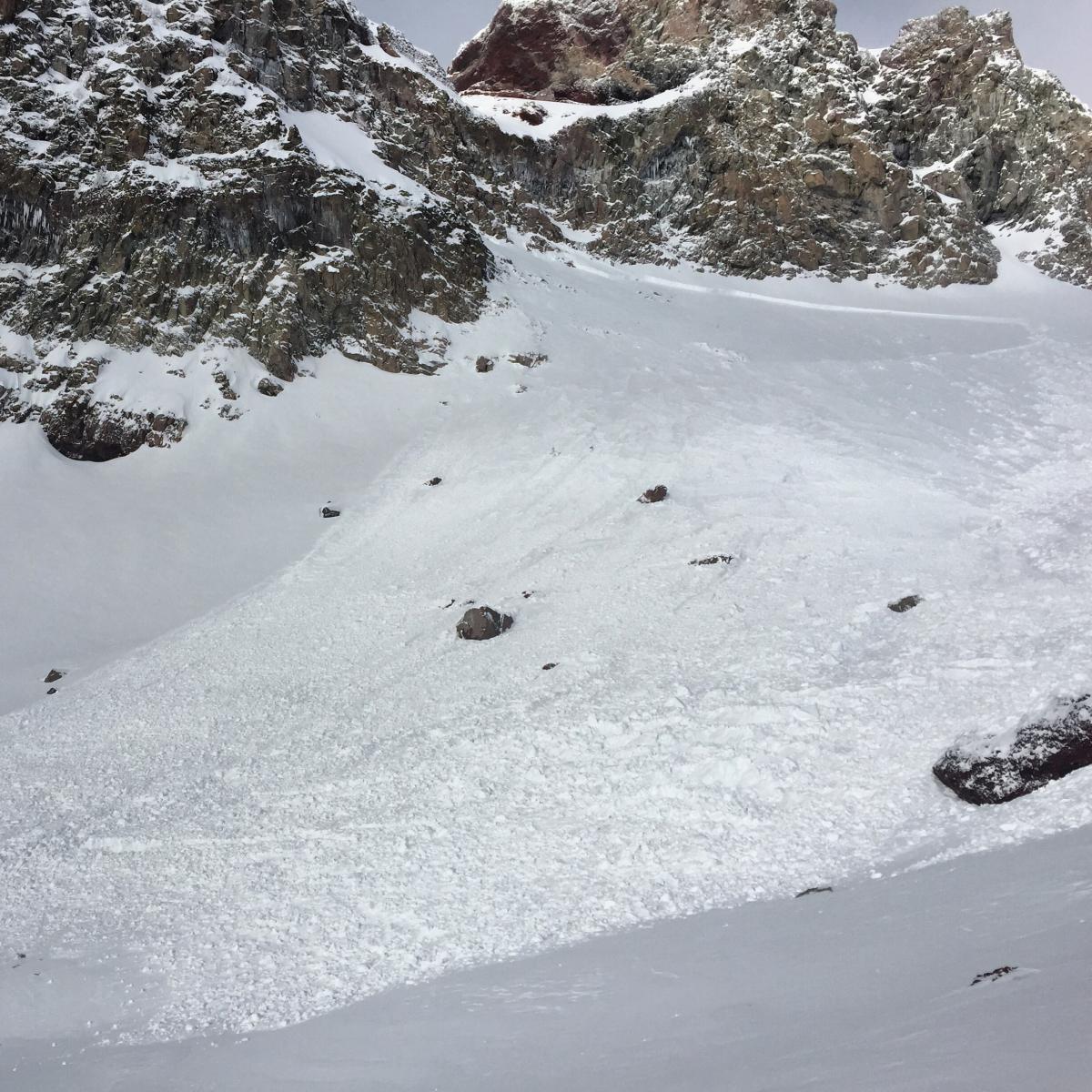
One natural and one human triggered (snowmobile) wind slab avalanches in mid/late November. Top: This is the north facing aspect off Green Butte, approx. 9,000 feet. Bottom: East aspect of Green Butte, approx 8,800 feet.
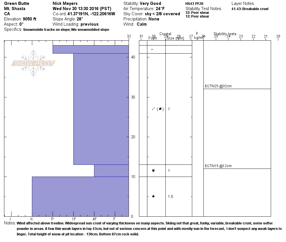
Yesterday, backcountry travels below, near, and above treeline on the south side of Mt Shasta noted a largely wind affected snowpack. A widespread, variable thickness, breakable sun crust was observed on most aspects and elevations. Bunny Flat is hosting a couple feet of snow, whereas above treeline snow depths from 250 to 300 cm (98-118 in.) were observed above Lake Helen (10,500 ft). In Avalanche Gulch, the skiing was generally poor with an overall firm snowpack. A couple compression tests in The Gulch by a local ski guide resulted in CT25-27/Q2-3 at 60cm deep. In the Old Ski Bowl area, just under Green Butte on a northerly aspect (9,050 ft), snow depths were 120-130 cm (47-51 in). Several extended column tests resulted in nothing spectacular, ECTN15@12cm and ECTN25@32cm, both poor shear quality (Q3). Overall at this location, the bottom 3/4 of the snowpack was rock solid with the top 1/4 wind affected and firm. Softer snow, absent of the sun crust, could be found mostly near treeline in protected, shady aspects.
Observations are limited thus far this season. We encourage you to submit your backcountry findings through our NEW big, blue 'submit observations' button, located under the 'advisory' tab on our website.
================================================================================
LOCAL AREA ROAD, NORDIC, AND SNOWMOBILE PARK STATUS:
The Sand Flat cross country ski trails are in good shape still and ready for your cross country skis and snow shoes. These are backcountry routes marked with blue diamonds on trees. Trails are not groomed. Snow shoers, please blaze a parallel trail to cross country skiers staying out of the skin track. These trails can be accessed via the Everett Memorial Highway. Thank you, and enjoy!
The Mt. Shasta Nordic Center is CLOSED for the time being but will be opening soon! The trails are covered in snow and they are working on getting things going this month. http://www.mtshastanordic.org
The Pilgrim Creek & Deer Mountain Snowmobile Parks are open, however there is no snow at these locations currently. One must drive down the 19 road (Military Pass) for an unknown distance to get to consistent snow before unloading. Head to our "Education" tab on our website and find the snowmobile section for trail information, grooming status, and other sledder resources.
The Castle Lake Road is OPEN. The Everett Memorial Highway is OPEN. The Castle Lake and Everett Hwy are plowed year round to the trailheads. The roads are not always first priority, so your dawn patrol powder mission might be ceased if the plow has not made it up yet. Siskiyou County does a great job keeping the roads clear. Be respectful of the plow drivers if you encounter them. If you get to Bunny Flat before or during when the plow is there, please park on the uphill, LEFT side of the parking lot as you drive in. This is uphill and lookers right of the bathrooms. Thank You!
The Five Red Flags of Avalanche Danger any time of year include: 1) Recent/current avalanche activity 2) Whumphing sounds or shooting cracks 3) Recent/current heavy snowfall 4) Strong winds transporting snow 5) Rapid warming or rain on snow.
Weather and Current Conditions
Weather Summary
Cold, dry, and windy will be the norm for the end of the work week as a ridge has settled over the area from the southwest. Expect sunny skies today with a high temperature hovering near 20 F near and above treeline. Winds can be expected to be 20-25 mph in the AM increasing this afternoon out of the North. Gusts near ridgetops and on the upper mountain could be much more. Brrr. Bundle up. Winds will continue to ramp up this evening into tomorrow with temperatures moderating into the 30's F. The forecast calls for some additional precipitation this weekend as a front is pushed onshore Saturday night. More on that later!
================================
In Mt Shasta City at 0500, we have a current temperature of 31 F. Skies are clear with calm wind.
On Mt Shasta (South Side) in the last 24 hours...
Old Ski Bowl - 7,600 feet, the current temperature is 17 degrees F. Snow on the ground totals 45 inches with no new snow and .5 inches of settlement. Temperatures have ranged from 16 F to 27 F.
Gray Butte - 8,000 feet, the current temperature is 19 degrees F. Temperatures have ranged from 17 F to 26 F. Average wind speed over the last 24 hours was 10 mph out of the West, with a max gust to 28 mph, WNW.
Mt Eddy Range (West side of Interstate-5)...
Castle Lake - 5,600 feet, the current temperature is 22 degrees F. Temperatures have ranged from 22 F to 31 F. Snow on the ground totals 17 inches with no new snow and .5 inch of settlement.
Mt Eddy - 6,500 feet, the current temperature is 20 degrees F. Temperatures have ranged from 19 F to 28 F. Snow on the ground measures 21 inches with no new snow and .5 inch of settlement. Winds have been easterly in nature with an average of 2 mph, and a maximum gust of 9 mph, SW.
THIS SEASON PRECIPITATION for MT SHASTA CITY: Since October 1st (the wet season), we have received 16.47 inches of water, normal is 7.36 inches, putting us at 223% of normal. For the month of November we received 4.60 inches of water, normal is 5.08 inches, putting us at 90% of normal, and finally... for the year of 2016 we've received 49.37 inches of water, normal is 35.36 inches, putting us at 139% of normal.
Always check the weather before you attempt to climb Mt Shasta. Further, monitor the weather as you climb. Becoming caught on the mountain in any type of weather can compromise life and limb. Be prepared.
| 0600 temperature: | 15 |
| Max. temperature in the last 24 hours: | 28 |
| Average wind direction during the last 24 hours: | WNW |
| Average wind speed during the last 24 hours: | 5 mi/hr |
| Maximum wind gust in the last 24 hours: | 10-15 mi/hr |
| New snowfall in the last 24 hours: | 0 inches |
| Total snow depth: | 27 inches |
Two Day Mountain Weather Forecast
Produced in partnership with the Medford NWS
| For 7000 ft to 9000 ft | |||
|---|---|---|---|
|
Thursday (4 a.m. to 10 p.m.) |
Thursday Night (10 p.m. to 4 a.m.) |
Friday (4 a.m. to 10 p.m.) |
|
| Weather | Sunny | Mostly clear, blustery | Mostly sunny, with a high near 36. North northwest wind around 20 mph, with gusts as high as 29 mph. |
| Temperature (°F) | 29 | 17 | 36 |
| Wind (mi/hr) | North 10-15, G-25 mph | North 20-25, G-35 mph | North 20, G-30 mph |
| Precipitation SWE / Snowfall (in) | / 0 | / 0 | / 0 |
| For 9000 ft to 11000 ft | |||
| Thursday | Thursday Night | Friday | |
| Weather | Sunny | Mostly clear | Mostly sunny |
| Temperature (°F) | 14 | 19 | 27 |
| Wind (mi/hr) | North 35-45 mph with gusts higher along exposed areas. Wind chill values as low as -13. | North 0 | North 50-60 mph, decreasing to 40-50 mph. Wind chill values as low as -6. |
| Precipitation SWE / Snowfall (in) | / 0 | / 0 | / 0 |

