

You are here
Avalanche Advisory for 2016-12-04 07:07:44
- EXPIRED ON December 5, 2016 @ 7:07 amPublished on December 4, 2016 @ 7:07 am
- Issued by Nick Meyers - Shasta-Trinity National Forest
Bottom Line
For today, LOW avalanche danger allows for normal caution for backcountry users within the forecast area. Don't let your antenna down however. Lower elevations still host shallow buried objects. Steep slopes at higher elevations on Mt Shasta could also provide for a slide for life without proper self-arrest as smooth and firm snow conditions exist. Always practice safe backcountry travel habits.


Avalanche Problem 1: Normal Caution
-
Character ?

-
Aspect/Elevation ?
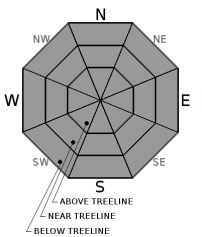
-
Likelihood ?CertainVery LikelyLikelyPossible
 Unlikely
 -
Size ?HistoricVery LargeLargeSmall

Normal caution is advised for our entire forecast area today. An inch or two of new snow is expected with the incoming storm, however by the time it arrives most will be having dinner or tucked in bed! The new snow is not expected to increase the avalanche danger today.
Train like you fight, fight like you train. Yes, the avalanche danger is LOW.... NO, you should not throw caution to the wind. Now is a great time to practice and hone your backcountry travel skills. When you wake up, look outside. What's the weather like? What's the snow look like? Pay attention to your surroundings before you even set your foot outside your car at the trailhead. Make a plan, discuss it. Does it make sense? Does it fit the days avalanche danger and avalanche problems? Be the sqeaky wheel! Evaluate the snowpack as you make your way into the backcountry. Do you need to change your plan? Are you seeing any of mother natures obvious, FREE signs of instability? Shooting cracks, whoomfing, recent avalanches, recent heavy snow, rapid warming, wind blowing snow? Moving through avalanche terrain? Move one at a time, avoid terrain traps, determine safe zones. Practicing all this now will ensure safe and fun backcountry skiing and riding when conditions are not so friendly.
Forecast Discussion
The 2016/17 winter in Mt Shasta started wonderfully in October/November and has deposited a solid base of snow on the mountain, setting us up for a great winter. We've already had several good size storms and avalanches and if the early season is any indicator of what is to come, we should be in for a good show! The NWS Climate Prediction Center shows Northern California to host below normal temperatures and above normal precipitation for the next month. A chilly, white Christmas we hope.
Snow totals on the mountain range from 2-4 feet below and near treeline. One will find about 4-6 feet at upper elevations. West of I-5 in the Castle/Mt Eddy regions, snow totals are less but still in the 1-2 foot range, nothing to shake a stick at.
Our forecast area has received strictly wind and chilly temperatures over the past week. We saw an impressive and short lived rapid warming trend (10-20 degrees F) over the past 36 hours that did not result in any instability. All this is coming to an end today. While nothing to write home about, temperatures will plummet as the Day of the Lord progresses and we'll see increasing clouds hosting a blip of snow over Siskiyou County. The highest snow totals will remain north of us, the Crater Lake/Diamond Lake area. Mt Shasta should see an inch or two of snow with snow levels down to about 1,500 feet. Firm, wind sculpted snow with scoured ridgelines is again the soup de jour today for any backcountry skiers or riders. Any new snow we get will likely blow off the mountain due to the moderate to high west/northwest winds we receive. A few very isolated areas below and near treeline may host a small pocket of wind deposited snow. These areas are not expected to pose a life threat to backcountry users.
Be cautious of smooth and firm snow on steep slopes. An ice axe, crampons and a helmet are absolutely necessary during conditions as such.
Recent Observations
A few photo observations were submitted from the Gray Butte area yesterday. Conditions have remained static over the week. The rapid 10-20 degree warming trend we experienced yesterday did not result in any major instabilities from reports though did soften snow on most aspects, challenging some skier skills. One very small loose surface slough was reported near treeline on Gray Butte on a westerly aspect, 7,800 feet. Temps will cool drastically today locking the snow back up. Variable snow conditions continue below and near treeline with firm and wind scoured snow dominating above treeline and even some areas of icy, slick crust.
Steady northwest winds blew yesterday, 30-40 mph with gusts into the 70 mph range up until 1200-1300 hours. Winds calmed and switched to easterly in nature, 5-10 mph with gusts 20-30 mph.
Please submit your observations via our new 'SUBMIT OBSERVATIONS', big BLUE buttons under the advisory tab. It's easy and helps us give and for you to get the BEST possible avalanche advisory. Muchos Gracias!
================================================================================
LOCAL AREA ROAD, NORDIC, AND SNOWMOBILE PARK STATUS:
The Sand Flat cross country ski trails are in good shape still and ready for your cross country skis and snow shoes. These are backcountry routes marked with blue diamonds on trees. Trails are not groomed. Snow shoers, please blaze a parallel trail to cross country skiers staying out of the skin track. These trails can be accessed via the Everett Memorial Highway. Thank you, and enjoy!
The Mt. Shasta Nordic Center is CLOSED for the time being but will be opening soon! The trails are covered in snow and they are working on getting things going this month. http://www.mtshastanordic.org
The Pilgrim Creek & Deer Mountain Snowmobile Parks are open, however there is no snow at these locations currently. One must drive down the 19 road (Military Pass) for an unknown distance to get to consistent snow before unloading. Head to our "Education" tab on our website and find the snowmobile section for trail information, grooming status, and other sledder resources.
The Castle Lake Road is OPEN. The Everett Memorial Highway is OPEN. The Castle Lake and Everett Hwy are plowed year round to the trailheads. The roads are not always first priority, so your dawn patrol powder mission might be ceased if the plow has not made it up yet. Siskiyou County does a great job keeping the roads clear. Be respectful of the plow drivers if you encounter them. If you get to Bunny Flat before or during when the plow is there, please park on the uphill, LEFT side of the parking lot as you drive in. This is uphill and lookers right of the bathrooms. Thank You!
The Five Red Flags of Avalanche Danger any time of year include: 1) Recent/current avalanche activity 2) Whumphing sounds or shooting cracks 3) Recent/current heavy snowfall 4) Strong winds transporting snow 5) Rapid warming or rain on snow.
Weather and Current Conditions
Weather Summary
A long break in the snow action will end today. No need to get your powder boards out yet however as this storm is rather underwhelming. Cold air is dropping down from the north as we speak and will continue to drop temperatures in the area as the day progresses. Associated precipitation will begin to fall later in the day, only to the tune of a couple inches at best, more like maybe an inch or so. Near and above treeline may see a bit more snow in areas of wind drift. Overall, this storm will only bring just a slight refresh to the snowpack. It has been a windy week on the mountain and this fact will remain. West/Nothwest winds will continue to crank above treeline and on the upper mountain, likely keeping our scoured firm snowpack... scoured and firm! Any new snow probably won't stick to well, except below treeline and in some areas near treeline. One can expect the snow level to drop to about 1,500 feet by Monday, but by the time it does that, most of the precipitation will have alreay fallen. Tuesday will be the coldest day of the year thus far. A short break and another weak system will arrive Tuesday also. An additional and stronger system is expected later in the week. Cheers!
================================
In Mt Shasta City at 0500, we have a current temperature of 38 F, four degrees warmer than yesterday. Skies are mostly clear with calm wind.
On Mt Shasta (South Side) in the last 24 hours...
Old Ski Bowl - 7,600 feet, the current temperature is 32 degrees F. Snow on the ground totals 42 inches with with no new snow or precipitation and 1 inch settlement. Temperatures have ranged from 32 F to 42F.
Gray Butte - 8,000 feet, the current temperature is 39 degrees F. Temperatures have ranged from 35 F to 46 F. Winds blew hard out of the northwest yesterday, averaging 30-40 mph with gusts to 71 mph up until about 1300. Winds calmed and shifted to easterly in nature, averaging 5-10 mph with a gust to 28 mph out of the WNW.
Mt Eddy Range (West side of Interstate-5)...
Castle Lake - 5,600 feet, the current temperature is 35 degrees F. Temperatures have ranged from 30 F to 38 F. Snow on the ground totals 16 inches with no new snow and little settlement.
Mt Eddy - 6,500 feet, the current temperature is 37 degrees F. Temperatures have ranged from 30 F to 41 F. Snow on the ground measures 18 inches with no new snow and 1 inch settlement. Winds have been southerly in nature with an average of 2 mph, and a maximum gust of 15 mph, SSE.
THIS SEASON PRECIPITATION for MT SHASTA CITY: Since October 1st (the wet season), we have received 16.47 inches of water, normal is 8.03 inches, putting us at 205% of normal. For the month of December we received 0.0 inches of water, normal is .67 inches, putting us at 0% of normal, and finally... for the year of 2016 we've received 49.37 inches of water, normal is 36.03 inches, putting us at 137% of normal.
Always check the weather before you attempt to climb Mt Shasta. Further, monitor the weather as you climb. Becoming caught on the mountain in any type of weather can compromise life and limb. Be prepared.
| 0600 temperature: | 35 |
| Max. temperature in the last 24 hours: | 45 |
| Average wind direction during the last 24 hours: | Northwest |
| Average wind speed during the last 24 hours: | 5-10 mi/hr |
| Maximum wind gust in the last 24 hours: | 15 mi/hr |
| New snowfall in the last 24 hours: | 0 inches |
| Total snow depth: | 25 inches |
Two Day Mountain Weather Forecast
Produced in partnership with the Medford NWS
| For 7000 ft to 9000 ft | |||
|---|---|---|---|
|
Sunday (4 a.m. to 10 p.m.) |
Sunday Night (10 p.m. to 4 a.m.) |
Monday (4 a.m. to 10 p.m.) |
|
| Weather | Rain and snow likely after 10am... Mostly cloudy...Chance of precipitation is 60%. | Rain and snow likely before 10pm, then a chance of snow. Mostly cloudy... Blustery... Chance of precipitation is 60%. | A slight chance of snow before 10am, then a chance of snow showers after 4pm... Partly sunny... Blustery... Chance of precipitation is 30%. |
| Temperature (°F) | 38 F (AM) --> 32 F (PM) | 21 | 25 |
| Wind (mi/hr) | West/Northwest 5-10 mph | North/Northwest 10-15 mph | West/Northwest 10-15 mph |
| Precipitation SWE / Snowfall (in) | / 0-.5 | / 0-.5 | / 0-.5 |
| For 9000 ft to 11000 ft | |||
| Sunday | Sunday Night | Monday | |
| Weather | Snow likely, mainly after 10am...Mostly cloudy... Windy... Chance of precipitation is 70%. | Snow likely, mainly before 10pm.... Cloudy, then gradually becoming partly cloudy... Chance of precipitation is 70% | A slight chance of snow before 10am, then a chance of snow showers after 4pm. Partly sunny...Windy...Chance of precipitation is 30%. |
| Temperature (°F) | Falling to 21 F by 1700 | 17 | 17 |
| Wind (mi/hr) | West 30-40 mph in more exposed areas, less down in gully bottoms. | West/Northwest 1-2 | West/Northwest 50-55 mph with gusts higher |
| Precipitation SWE / Snowfall (in) | / 1-2 | / 0-1 | / 0-.5 |

