

You are here
Avalanche Advisory for 2016-12-14 06:58:27
- EXPIRED ON December 15, 2016 @ 6:58 amPublished on December 14, 2016 @ 6:58 am
- Issued by Nick Meyers - Shasta-Trinity National Forest
Bottom Line
A winter storm is forecasted to bring high westerly wind and several feet of snow to above treeline terrain over the next two days. As the storm progresses, expect the avalanche danger to rise to CONSIDERABLE today above 7,000 feet. New wind slabs will gain size and depth throughout the day. Natural and human triggered avalanches are possible. The bottom line: New wind slab avalanche danger will rise as time goes by and backcountry skiers and riders increase elevation.


Avalanche Problem 1: Wind Slab
-
Character ?

-
Aspect/Elevation ?
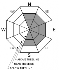
-
Likelihood ?CertainVery LikelyLikelyPossible
 Unlikely
 -
Size ?HistoricVery LargeLargeSmall

Both natural and human triggered wind slab avalanches are possible today. Moderate westerly winds, increasing today, will continue to load primarily leeward aspects NE-E-SE facing slopes above treeline, but not limited to. New snow and wind will rapidly build wind slabs on our old, firm snow and the avalanche danger will increase as the day progresses. Heavier, wet snow may sit on top of lighter density snow because of our storms temperature profile, cold to warm. Look for recent signs of avalanche danger such as recent avalanches or shooting cracks within the new snow. This avalanche problem will be most prevalent above treeline and in isoated areas near treeline. Below treeline, expect mostly rain on snow and overall lower avalanche danger.
Forecast Discussion
The avalanche danger has changed overnight as a warm, wet and windy system has moved into the area. This system is forecasted to provide ample precipitation and wind through Thursday. For all areas above 7,000 feet, several feet of new snow is possible over the next two days. Pair that up with strong westerly winds and several red flags for avalanche danger shoot up immediately. Above treeline, new wind slabs have already begun to form overnight as wind and new snow has impacted the forecast area. These new wind slabs will grow in size over the next 48 hours. Natural and human triggered avalanches become more likely throughout the storm. New wind slabs will rest on a mix of frozen ice crusts, icy snow surfaces and old wind packed snow. Monitor the snowpack stability carefully today. Recent avalanches are one of the best clues of instability.
===============================================================
LOCAL AREA ROAD, NORDIC, AND SNOWMOBILE PARK STATUS:
The Sand Flat cross country ski trails are in good shape still and ready for your cross country skis and snow shoes. These are backcountry routes marked with blue diamonds on trees. Trails are not groomed. Snow shoers, please blaze a parallel trail to cross country skiers staying out of the skin track. These trails can be accessed via the Everett Memorial Highway. Thank you, and enjoy!
The Mt. Shasta Nordic Center is CLOSED for the time being but will be opening soon! The trails are covered in snow and they are working on getting things going this month. http://www.mtshastanordic.org
The Pilgrim Creek & Deer Mountain Snowmobile Parks are open, however there is no snow at these locations currently. One must drive down the 19 road (Military Pass) for several miles to get to consistent snow before unloading. Private industry is logging out there so watch out for log trucks. Head to our "Education" tab on our website and find the snowmobile section for trail information, grooming status, and other sledder resources.
The Castle Lake Road is OPEN. The Everett Memorial Highway is OPEN. The Castle Lake and Everett Hwy are plowed year round to the trailheads. The roads are not always first priority, so your dawn patrol powder mission might be ceased if the plow has not made it up yet. Siskiyou County does a great job keeping the roads clear. Be respectful of the plow drivers if you encounter them. If you get to Bunny Flat before or during when the plow is there, please park on the uphill, LEFT side of the parking lot as you drive in. This is uphill and lookers right of the bathrooms. Thank You!
The Five Red Flags of Avalanche Danger any time of year include: 1) Recent/current avalanche activity 2) Whumphing sounds or shooting cracks 3) Recent/current heavy snowfall 4) Strong winds transporting snow 5) Rapid warming or rain on snow.
Recent Observations
Yesterday, before the storm, moderate to strong northwest winds howled for several days above treeline within our forecast area. Windward slopes remained scoured. Firm, icy snow surface conditions was the norm above treeline and a stout rain crust capped snow surfaces near and below treeline. Overall, variable conditions challenged backcountry travelers. (New observation from Castle Lake - "NW Slope Left Peak" below.)
Overnight, we have received about 3 inches of new snow at 6,800 feet and 5 inches at 7,800 feet on Mt Shasta. The west side received about 3-4 inches new. Winds have been averaging 10-15 mph, northwest to southwest, with gusts to 28 mph. More wind and another inch plus of water is forecasted for today. Snow levels will rise to 7,000 feet.
================================================================================
Have you seen our new, BIG BLUE buttons on our website? Yep, thats them, just up and to your left! You can use those and absolutely should. No more email, no more text, no more messing around! So cool. Please submit your observations by clicking either 'snowpack' or 'avalanche' observation and follow the template. Just a photo? Great! Snowpit profile? Awesome! Video, notes, weather...you name it, there is a place for it. It's simple, easy and fun and extremely useful for us and other users. We also have a drop down menu within the obs template that allows you to submit observations from "out of the forecast area". Heading to Crater Lake or Mt Lassen? Submit some obs! This will help us create the BEST possible avalanche advisory AND provide a great place for peeps to go for checking backcountry conditions. Saddle up!
Weather and Current Conditions
Weather Summary
I can feel collective pain amongst powder hounds this morning... the feeling of rain on snow, warming temps and high snow levels for a storm that is forecasted to really let loose! Let's hope we are just taking one for the team this round and the remainder of the winter will host nothing but endless powder days where we all keep a snorkel in our pack. Indeed, a good looking storm is upon the forecast area. Temperatures are going to warm with this one today and cause snow levels to climb to about 6,500 to 7,000 feet. This storm, all said and done by Friday, is expected to bring upwards of 2.65 inches of water to the area. Naturally, upper elevations could see several feet of new snow. Lower to mid elevations will struggle with rain on snow and/or wet, heavy snow. This storm is not holding back with wind... expect very windy conditions above treeline, with 40-50 mph winds, southwest in nature today, increasing to 50-60 mph tonight. Near the end of this system Friday, temperatures will begin to cool considerably with lows in the single digits in some areas. Precipitation for the coming weekend looks minimal at this point.
================================
In Mt Shasta City at 0500, we have a current temperature of 35 F with rain.
On Mt Shasta (South Side) in the last 24 hours...
Old Ski Bowl - 7,600 feet, the current temperature is 27 degrees F. Snow on the ground totals 57 inches with 5 inches new snow. Temperatures have ranged from 22F to 29F.
Grey Butte - 8,000 feet, the current temperature is 27 degrees F. Temperatures have ranged from 20 F to 27 F. Winds have averaged 10-15 mph, westerly in nature with gusts to 28 mph.
Mt Eddy Range (West side of Interstate-5)...
Castle Lake - 5,600 feet, the current temperature is 30 degrees F. Temperatures have ranged from 27 F to 34 F. Snow on the ground totals 20 inches with 4 inches new snow.
Mt Eddy - 6,500 feet, the current temperature is 32 degrees F. Temperatures have ranged from 25 F to 34 F. Snow on the ground measures 25 inches with 3 inches new snow. Winds have averaged 1-2 mph and southerly, with gusts to 9 mph.
THIS SEASON PRECIPITATION for MT SHASTA CITY: Since October 1st (the wet season), we have received 17.82 inches of water, normal is 10.43 inches, putting us at 170% of normal. For the month of December we received 1.35 inches of water, normal is 3.07 inches, putting us at 43% of normal, and finally... for the year of 2016 we've received 50.72 inches of water, normal is 38.43 inches, putting us at 131% of normal.
Always check the weather before you attempt to climb Mt Shasta. Further, monitor the weather as you climb. Becoming caught on the mountain in any type of weather can compromise life and limb. Be prepared.
| 0600 temperature: | 31 |
| Max. temperature in the last 24 hours: | 31 |
| Average wind direction during the last 24 hours: | SW - NW |
| Average wind speed during the last 24 hours: | 5-10 mi/hr |
| Maximum wind gust in the last 24 hours: | 28 mi/hr |
| New snowfall in the last 24 hours: | 3-5 inches |
| Total snow depth: | 31 inches |
Two Day Mountain Weather Forecast
Produced in partnership with the Medford NWS
| For 7000 ft to 9000 ft | |||
|---|---|---|---|
|
Wednesday (4 a.m. to 10 p.m.) |
Wednesday Night (10 p.m. to 4 a.m.) |
Thursday (4 a.m. to 10 p.m.) |
|
| Weather | Rain and snow before 1pm, then rain between 1pm and 4pm, then rain and snow after 4pm. The rain and snow could be heavy at times. Windy | Rain and snow. The rain and snow could be heavy at times. Windy | Rain and snow, becoming all snow after 10am. The rain and snow could be heavy at times. |
| Temperature (°F) | 36 | 31 | 35 |
| Wind (mi/hr) | South 25-30 mph | South 25-30 mph | South/Southwest 10-15 mph |
| Precipitation SWE / Snowfall (in) | / 3-5 | / 1-3 | / 4-8 |
| For 9000 ft to 11000 ft | |||
| Wednesday | Wednesday Night | Thursday | |
| Weather | Snow before 4pm, then snow showers after 4pm. The snow could be heavy at times. Windy | Snow showers before 7pm, then snow after 7pm. The snow could be heavy at times. Windy | Snow. The snow could be heavy at times. Windy |
| Temperature (°F) | 28 | 24 | 24 |
| Wind (mi/hr) | Southwest 40-50 mph with gusts 60+ mph | South/Southwest 15-20 | Southwest 50-60 mph |
| Precipitation SWE / Snowfall (in) | / 15-20 | / 25-30 | / 10-15 |

