

You are here
Avalanche Advisory for 2016-12-15 06:55:21
- EXPIRED ON December 16, 2016 @ 6:55 amPublished on December 15, 2016 @ 6:55 am
- Issued by Nick Meyers - Shasta-Trinity National Forest
Bottom Line
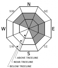
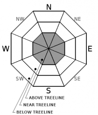
Mt Shasta has received 2 feet of new snow with strong SW wind in less that 48 hours. HIGH avalanche danger is expected for above treeline terrain today for wind and storm slab avalanches. Both natural and human triggered avalanches are likely. Below treeline, expect MODERATE danger and near treeline, CONSIDERABLE avalanche danger. As one gains elevation above the rain/snow level, the avalanche danger will increase. Don't let clearing skies this afternoon lure you onto unstable avalanche terrain.


Avalanche Problem 1: Wind Slab
-
Character ?

-
Aspect/Elevation ?
-
Likelihood ?CertainVery LikelyLikelyPossible
 Unlikely
 -
Size ?HistoricVery LargeLargeSmall

The wind slab problem today will be confined to near and primarily above treeline slopes. Wind slabs are often smooth and rounded and sometimes sound hollow, and can range from soft to hard, predictable to unpredictable due to slab stiffness and spatial variability.
Terrain that is NW-N-NE-E-SE facing and steeper than 30 degrees will be most suspect for new wind slabs. Slabs could be small to large in size and depth. Wind slabs today could be very destructive, dangerous and sensitive to trigger due to rapid loading of new snow on leeward slopes. New slabs sit on variable surfaces, mostly smooth crusts and/or firm, icy old snow.
In locations where signs of recent wind loading has occured, it will be best to avoid these slopes. Give runout zones a wide berth when natural avalanches are expected or when others may be traveling above you. Remotely triggered slides are possible during heavy loading events. Test slopes, snow pits, slope cuts and cornice drops can provide some level of information on stabilty. Proceed with caution!
Avalanche Problem 2: Storm Slab
-
Character ?

-
Aspect/Elevation ?
-
Likelihood ?CertainVery LikelyLikelyPossible
Unlikely
-
Size ?HistoricVery LargeLargeSmall
Storm slabs involve a release of a soft cohesive layer (slab) of new snow which breaks within the storm snow or on a old snow surface. Storm slabs can last for a few hours to a few days. This avalanche problem will be most prevalent at higher elevations on all aspects. Avoid this terrain or choose gentler slopes, less than 30 degrees in steepness. Give runout zones a wide berth when natural avalanches are possible during periods of heavy snowfall. Storm slabs tend to settle out and stabilize within a few days.
Forecast Discussion
The storm that began on the evening of the 14th has brought high winds and a lot of precipitation to the forecast area in less than 48 hours. Snow levels have hovered around 7,000 feet. Castle Lake and Mt Eddy areas have received mostly rain on snow, excepet for the upper ramparts of Mt Eddy. On Mt Shasta, southwesterly winds have averaged 20-30 mph with gusts 40-50 mph over the course of the storm. The Old Ski Bowl weather station has recorded 18 inches of new snow since the night of the 14th. An additional 6-8 inches is possible today above 7,000 feet with continued southwest wind. This has drastically increased the avalanche danger. Rapid loading of new snow paired with consistently moderate to strong wind speeds is a certain recipe for an avalanche. Snow does not like rapid change. When one observes new snow accumulation and/or wind as such, it's a definite red flag. If the skies begin to clear this afternoon, that is NOT your cue to go shred your favorite powder line. One will need to proceed with caution, make safe terrain choices, expose only one at a time to avalanche prone slopes and stay out of avalanche runnout zones. Know your group dynamics, pay attention, communicate, beacon check!? Be extra careful today. Those few extra turns above treeline may not be worth it.
===============================================================
LOCAL AREA ROAD, NORDIC, AND SNOWMOBILE PARK STATUS:
The Sand Flat cross country ski trails are in good shape still and ready for your cross country skis and snow shoes. These are backcountry routes marked with blue diamonds on trees. Trails are not groomed. Snow shoers, please blaze a parallel trail to cross country skiers staying out of the skin track. These trails can be accessed via the Everett Memorial Highway. Thank you, and enjoy!
The Mt. Shasta Nordic Center is CLOSED for the time being but will be opening soon! The trails are covered in snow and they are working on getting things going this month. http://www.mtshastanordic.org
The Pilgrim Creek & Deer Mountain Snowmobile Parks are open, however there is no snow at these locations currently. One must drive down the 19 road (Military Pass) for several miles to get to consistent snow before unloading. Private industry is logging out there so watch out for log trucks. Head to our "Education" tab on our website and find the snowmobile section for trail information, grooming status, and other sledder resources.
The Castle Lake Road is OPEN. The Everett Memorial Highway is OPEN. The Castle Lake and Everett Hwy are plowed year round to the trailheads. The roads are not always first priority, so your dawn patrol powder mission might be ceased if the plow has not made it up yet. Siskiyou County does a great job keeping the roads clear. Be respectful of the plow drivers if you encounter them. If you get to Bunny Flat before or during when the plow is there, please park on the uphill, LEFT side of the parking lot as you drive in. This is uphill and lookers right of the bathrooms. Thank You!
The Five Red Flags of Avalanche Danger any time of year include: 1) Recent/current avalanche activity 2) Whumphing sounds or shooting cracks 3) Recent/current heavy snowfall 4) Strong winds transporting snow 5) Rapid warming or rain on snow.
Recent Observations
Yesterday, observations around the Bunny Flat area and up along Green Butte ridge to treeline found easy failures with propagation during extended column and compression tests. A small test slope ski cut on a steep rollover onto the road above Bunny Flat resulted in the entire feature releasing with shooting cracks extending across the area. Snow did not slide due to bridging and support from road. Good visual to keep in mind for bigger, less supported slopes and features. The layer of greatest concern lies 25-35 cm down from the surface of the snowpack, just above a stout rain crust. With the snow level around 7,000 feet for most of the storm, heavy/wet snow will be found below treeline. Near and above treeline, all snow has been falling. Conditions are expected to remain touchy today. (View obs from yesterday below)
================================================================================
Have you seen our new, BIG BLUE buttons on our website? Yep, thats them, just up and to your left! You can use those and absolutely should. No more email, no more text, no more messing around! So cool. Please submit your observations by clicking either 'snowpack' or 'avalanche' observation and follow the template. Just a photo? Great! Snowpit profile? Awesome! Video, notes, weather...you name it, there is a place for it. It's simple, easy and fun and extremely useful for us and other users. We also have a drop down menu within the obs template that allows you to submit observations from "out of the forecast area". Heading to Crater Lake or Mt Lassen? Submit some obs! This will help us create the BEST possible avalanche advisory AND provide a great place for peeps to go for checking backcountry conditions. Saddle up!
Weather and Current Conditions
Weather Summary
The wet and windy storm moving overhead will slide east and out of the area later today. Precipitation and wind will decrescendo this afternoon. Expect gradual clearing today with some remaining southwesterly wind. The snow level will sit at about 7,000 feet this morning and lingering snow/rain for the forecast area will finish us off with a predicted .42 inches additional water by 4pm.
A cold front follows closely behind dropping temperatures drastically for Friday and this weekend. Colder air will be felt as early as this afternoon with overnight low's in the single digits potentially. Unfortunately as Mother Nature has it, there is no associated precip with the cold front. Northwest wind will eventually move back into town this weekend too. So yes, you read it right... unfortunately, precipitation will evade the falling temperatures today and winter weather will hit the hold button for now.
================================
In Mt Shasta City at 0500, we have a current temperature of 46 F with rain.
On Mt Shasta (South Side) in the last 24 hours...
Old Ski Bowl - 7,600 feet, the current temperature is 31 degrees F. Snow on the ground totals 69 inches with 12 inches new snow. Temperatures have ranged from 29F to 31F.
Grey Butte - 8,000 feet, the current temperature is 31 degrees F. Temperatures have ranged from 27 F to 31 F. Winds have averaged 20 mph, southwesterly in nature with gusts to 49 mph, west/southwest.
Mt Eddy Range (West side of Interstate-5)...
Castle Lake - 5,600 feet, the current temperature is 36 degrees F. Temperatures have ranged from 31 F to 36 F. Snow on the ground totals 18 inches with 2 inches of settlement due to rain on snow.
Mt Eddy - 6,500 feet, the current temperature is 33 degrees F. Temperatures have ranged from 32 F to 34 F. Snow on the ground measures 25 inches with little new snow, mostly rain on snow. Mt Eddy has been sitting right on the rain/snow line. Winds have averaged 3 mph and southwesterly, with gusts to 15 mph.
THIS SEASON PRECIPITATION for MT SHASTA CITY: Since October 1st (the wet season), we have received 18.97 inches of water, normal is 10.68 inches, putting us at 177% of normal. For the month of December we received 2.5 inches of water, normal is 3.32 inches, putting us at 75% of normal, and finally... for the year of 2016 we've received 51.87 inches of water, normal is 38.68 inches, putting us at 134% of normal.
Always check the weather before you attempt to climb Mt Shasta. Further, monitor the weather as you climb. Becoming caught on the mountain in any type of weather can compromise life and limb. Be prepared.
| 0600 temperature: | 33 |
| Max. temperature in the last 24 hours: | 35 |
| Average wind direction during the last 24 hours: | Southwest |
| Average wind speed during the last 24 hours: | 10-20 mi/hr |
| Maximum wind gust in the last 24 hours: | 30 mi/hr |
| New snowfall in the last 24 hours: | 6-12 inches |
| Total snow depth: | 35-40 inches |
Two Day Mountain Weather Forecast
Produced in partnership with the Medford NWS
| For 7000 ft to 9000 ft | |||
|---|---|---|---|
|
Thursday (4 a.m. to 10 p.m.) |
Thursday Night (10 p.m. to 4 a.m.) |
Friday (4 a.m. to 10 p.m.) |
|
| Weather | Rain before 10am, then rain, possibly mixed with snow. The rain could be heavy at times. Breezy. Snow level near 7,000 feet. | Snow showers possible, mainly before 10pm. Cloudy, then gradually becoming partly cloudy. | A 20 percent chance of snow showers before 10am. Mostly sunny |
| Temperature (°F) | 35 --> 31 | 15 | 22 |
| Wind (mi/hr) | Southwest 10-15 mph | North/Northwest 10-15 mph | North/Northwest 10-15 mph |
| Precipitation SWE / Snowfall (in) | / 0-1 | / 1-2 | / 0 |
| For 9000 ft to 11000 ft | |||
| Thursday | Thursday Night | Friday | |
| Weather | Snow. The snow could be heavy at times. Windy. | Snow showers possible, mainly before 10pm. Cloudy, then gradually becoming partly cloudy, . Windy. | Mostly sunny and cold. Windy. |
| Temperature (°F) | 21 | 8 | 8 |
| Wind (mi/hr) | Southwest 40-50 mph, decreasing this afternoon to 30-40 mph | Southwest, becoming northwest 6-8 | North/Northwest 20-30 mph |
| Precipitation SWE / Snowfall (in) | / 6-8 | / 1-3 | / 0 |

