

You are here
Avalanche Advisory for 2016-12-19 06:56:24
- EXPIRED ON December 20, 2016 @ 6:56 amPublished on December 19, 2016 @ 6:56 am
- Issued by Andrew Kiefer - Mt Shasta Avalanche Center
Bottom Line
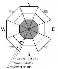
Above treeline, MODERATE avalanche danger exists on all aspects. Natural avalanches are unlikely and human triggered avalanches remain possible. The wind slab problem is the primary avalanche concern today. SE, E, and NE aspects above treeline are where wind slabs are most likely to be found. Near treeline and below treeline, the avalanche danger is LOW.


Avalanche Problem 1: Wind Slab
-
Character ?

-
Aspect/Elevation ?
-
Likelihood ?CertainVery LikelyLikelyPossible
 Unlikely
 -
Size ?HistoricVery LargeLargeSmall

Variable winds have blown and redistributed snow above treeline and continued to load leeward slopes. Backcountry travelers may encounter wind slabs ranging from six inches to several feet thick. Wind slabs may exist on all aspects above treeline, but primarily westerly winds have made easterly aspects most suspect. Visual observations are the best tool to use in determining the presence of wind slabs. Look for smooth and rounded pillows of snow, active wind transport, and cornice formations. Sometimes, these areas of wind loaded snow sound hollow. If you find yourself suddenly transitioning from hard, scoured snow to softer snow on a leeward slope, beware. It is best to avoid these areas today. Potentially prime starting zones lie just below ridgelines, in gullies, and on convex rolls. With the strong winds we have experienced recently, mid slope wind loading, and cross loading of terrain features are both possible today.
Forecast Discussion
It has been two days since the most recent avalanche activity has been observed or reported. During this time, cold temperatures, snow available for transport, and strong winds have kept the avalanche hazard steady. The recent avalanches are a good reminder that even days after a storm ends, wind can work to redistribute and load snow, and avalanches can occur on what was otherwise a stable snowpack.
The avalanche concerns in the advisory area are confined to upper elevation terrain. Near and below treeline, both natural and human triggered avalanches are unlikely. Variable surface conditions exist. Backcountry travelers should use caution and work to identify areas of unstable snow, as well challenging snow conditions like firm and icy surfaces and breakable crust.
==============================================================
LOCAL AREA ROAD, NORDIC, AND SNOWMOBILE PARK STATUS:
The Sand Flat cross country ski trails are in good shape still and ready for your cross country skis and snow shoes. These are backcountry routes marked with blue diamonds on trees. Trails are not groomed. Snow shoers, please blaze a parallel trail to cross country skiers staying out of the skin track. These trails can be accessed via the Everett Memorial Highway. Thank you, and enjoy!
The Mt. Shasta Nordic Center is CLOSED for the time being but will be opening soon! The trails are covered in snow and they are working on getting things going this month. http://www.mtshastanordic.org
The Pilgrim Creek & Deer Mountain Snowmobile Parks are open, however there is no snow at these locations currently. One must drive down the 19 road (Military Pass) for several miles to get to consistent snow before unloading. Private industry is logging out there so watch out for log trucks. Head to our "Education" tab on our website and find the snowmobile section for trail information, grooming status, and other sledder resources.
The Castle Lake Road is OPEN. The Everett Memorial Highway is OPEN. The Castle Lake and Everett Hwy are plowed year round to the trailheads. The roads are not always first priority, so your dawn patrol powder mission might be ceased if the plow has not made it up yet. Siskiyou County does a great job keeping the roads clear. Be respectful of the plow drivers if you encounter them. If you get to Bunny Flat before or during when the plow is there, please park on the uphill, LEFT side of the parking lot as you drive in. This is uphill and lookers right of the bathrooms. Thank You!
The Five Red Flags of Avalanche Danger any time of year include: 1) Recent/current avalanche activity 2) Whumphing sounds or shooting cracks 3) Recent/current heavy snowfall 4) Strong winds transporting snow 5) Rapid warming or rain on snow.
Recent Observations
A large, natural hard slab avalanche was revealed on Saturday morning. The avalanche occurred on the southeast slopes of Casaval Ridge, and ran into Avalanche Gulch. On Saturday afternoon, a medium sized skier triggered avalanche occurred in Sun Bowl. Luckily, no one was injured or buried in either avalanche event. Check out the details on both avalanches in the Observations section below.
Yesterday, a crown profile and investigation of the Casaval Ridge avalanche was conducted. The crown was measured to be 1-6ft deep, 1500 feet wide, and ran for 2000 vertical feet. The majority of the avalanche failed within newly wind deposited snow. In a 150-foot section of the crown near a large rock outcrop, the avalanche stepped down into deeper, older layers within the snowpack. The debris was 10-20ft deep minimum, and the avalanche ran over and far beyond Helen Lake.
Wind loaded snow and wind slabs were observed on many slopes throughout upper elevation terrain on Mount Shasta. Easterly aspects were especially subject to wind loading, and continuous blowing of snow above treeline has occurred for the past 3 days. Variable snow conditions exist at all elevations including breakable crust, scoured surfaces, wind pillows of loaded snow, firm and icy surfaces, and chalky powder. No signs of instability have been observed below or near treeline.
================================================================================
Have you seen our new, BIG BLUE buttons on our website? Yep, thats them, just up and to your left! You can use those and absolutely should. No more email, no more text, no more messing around! So cool. Please submit your observations by clicking either 'snowpack' or 'avalanche' observation and follow the template. Just a photo? Great! Snowpit profile? Awesome! Video, notes, weather...you name it, there is a place for it. It's simple, easy and fun and extremely useful for us and other users. We also have a drop down menu within the obs template that allows you to submit observations from "out of the forecast area". Heading to Crater Lake or Mt Lassen? Submit some obs! This will help us create the BEST possible avalanche advisory AND provide a great place for peeps to go for checking backcountry conditions. Saddle up!
Weather and Current Conditions
Weather Summary
A temperature inversion is in place within the advisory area this morning with our mountain weather stations showing temperatures about 10 degrees warmer than town level in Mount Shasta City. A series of fronts will move onshore today and continue throughout the week. The first front will be fairly weak, but will bring NW winds averaging 20-30mph, with 40-50mph gusts to upper elevation terrain. Mostly cloudy skies are expected to cover Siskiyou County, with highs of 30-40F degrees today. A wetter and windier front will move onshore late Monday night and into Tuesday morning. This front will bring gusty, northwest winds and a chance of snow and rain with freezing levels expected to rise to 7000ft.
===============================
In Mt Shasta City at 0500, we have a current temperature of 20 F.
On Mt Shasta (South Side) in the last 24 hours...
Old Ski Bowl - 7,600 feet, the current temperature is 33F degrees F. Snow on the ground totals 71 inches with no new settlement. Temperatures have ranged from 14F to 37F.
Grey Butte - 8,000 feet, the current temperature is 33 degrees F. Temperatures have ranged from 16F to 36 F. Winds blew out of the NE before shifting to the NW and have averaged 5-15 mph, with gusts 30-45mph.
Mt Eddy Range (West side of Interstate-5)...
Castle Lake - 5,600 feet, the current temperature is 33 degrees F. Temperatures have ranged from 11 F to 34 F. Snow on the ground totals 17 inches with little settlement.
Mt Eddy - 6,500 feet, the current temperature is 29 degrees F. Temperatures have ranged from 14 F to 31 F. Snow on the ground measures 25 inches with one inch settlement. Winds have averaged 2 mph with gusts to 12 mph, out of the SW.
THIS SEASON PRECIPITATION for MT SHASTA CITY: Since October 1st (the wet season), we have received 20.25 inches of water, normal is 11.75 inches, putting us at 172% of normal. For the month of December we received 3.78 inches of water, normal is 4.39 inches, putting us at 86% of normal, and finally... for the year of 2016 we've received 53.15 inches of water, normal is 39.75 inches, putting us at 134% of normal.
Always check the weather before you attempt to climb Mt Shasta. Further, monitor the weather as you climb. Becoming caught on the mountain in any type of weather can compromise life and limb. Be prepared.
| 0600 temperature: | 33 |
| Max. temperature in the last 24 hours: | 33 |
| Average wind direction during the last 24 hours: | NW |
| Average wind speed during the last 24 hours: | 5-15 mi/hr |
| Maximum wind gust in the last 24 hours: | 40 mi/hr |
| New snowfall in the last 24 hours: | 0 inches |
| Total snow depth: | 33 inches |
Two Day Mountain Weather Forecast
Produced in partnership with the Medford NWS
| For 7000 ft to 9000 ft | |||
|---|---|---|---|
|
Monday (4 a.m. to 10 p.m.) |
Monday Night (10 p.m. to 4 a.m.) |
Tuesday (4 a.m. to 10 p.m.) |
|
| Weather | Mostly Cloudy | Slight Chance Rain, then Wintery Mix likely | Wintery Mix Likely, then Chance Rain |
| Temperature (°F) | 39 | 30 | 38 |
| Wind (mi/hr) | West/Northwest 5-10 mph | West/Southwest 15-20mph | West/Northwest 10-15 mph |
| Precipitation SWE / Snowfall (in) | / 0 | / Trace | / Trace |
| For 9000 ft to 11000 ft | |||
| Monday | Monday Night | Tuesday | |
| Weather | Mostly Cloudy and Windy | Windy, Chance Snow | Snow Likely, and Windy |
| Temperature (°F) | 30 | 29 | 29 |
| Wind (mi/hr) | West, Northwest 20-30 mph | West 0 | West/Northwest 40-50mph |
| Precipitation SWE / Snowfall (in) | / 0 | / Trace | / 1-2 |

