

You are here
Avalanche Advisory for 2016-12-23 06:51:49
- EXPIRED ON December 24, 2016 @ 6:51 amPublished on December 23, 2016 @ 6:51 am
- Issued by Nick Meyers - Shasta-Trinity National Forest
Bottom Line
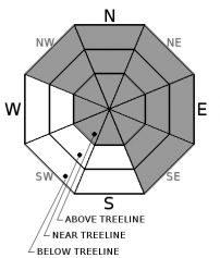
A winter storm warning is in effect until 4pm today. Upwards of a foot of new snow and moderate southwest wind is forecasted near and above treeline on Mt Shasta. New wind slabs will build on primarily leeward NW-N-NE-E-SE facing slopes. CONSIDERABLE danger will be reached near and above treeline on said leeward slopes. For all other aspects and elevations MODERATE danger will prevail. Expect increasing avalanche danger & sensitivity for human trigger throughout in the day.


Avalanche Problem 1: Wind Slab
-
Character ?

-
Aspect/Elevation ?
-
Likelihood ?CertainVery LikelyLikelyPossible
 Unlikely
 -
Size ?HistoricVery LargeLargeSmall

New wind slabs will need to be your primary focus for today. New wind slab avalanche danger will increase throughout the day as a winter storm brings northwest winds and upwards of a foot of new snow to upper elevations. Leeward, NW-N-NE-E-SE facing slopes at all elevations will experience the best wind loading and could be increasingly sensitive to trigger today. Slabs could be just a couple inches to several feet deep. Ridgelines, rock outcrops, gullies and other terrain features where wind loading is observed should be avoided. In areas where wind speeds are the greatest, mid-slope wind loading is possible. Remember, wind slabs can sensitive during the storm...but also hours to days after a storm as wind continues to transport snow.
As we saw in the large Casaval Ridge avalanche last week, the newer wind loaded snow stepped down into deeper layers, igniting an old persistent weak layer from early season. While unlikely and difficult to trigger, if new snow loading and perhaps the weight of a skier tipped the stress vs strength scale of an old wind slab, a large and destructive avalanche would be the result. These types of avalanches are hard to predict.
Powder is fun. Avalanches are not. Pay attention to your surroundings and the slope you are on or plan to ski. Have a plan, carry a beacon, shovel and probe and know how to use these items. When was the last time you practiced? If your answer is last year, you are behind the curve.
Forecast Discussion
New snow and wind is upon us this morning! Castle Lake and Mt Eddy regions continue to hang on to shallow snowpacks. A refresh from the storm will help, however rocks, manzanita bushes and other objects are hazards to avoid in those areas. As of yesterday, Castle Lake was completely frozen over and this season's figure skating and hockey try outs were in full swing. With a little bit of new snow up there, ice skating may be done for and skiing is marginal. On Mt Shasta, with a snowpack that will top 70 inches after this storm, one will find full winter conditions. Strong southwest wind and new snow on top of hard, firm existing snow surfaces will cause reason for concern today.
==============================================================
LOCAL AREA ROAD, NORDIC, AND SNOWMOBILE PARK STATUS:
The Sand Flat cross country ski trails are in good shape and ready for your cross country skis and snow shoes. These are backcountry routes marked with blue diamonds on trees. Trails are not groomed. Snow shoers, please blaze a parallel trail to cross country skiers staying out of the skin track. These trails can be accessed via the Everett Memorial Highway. Thank you, and enjoy!
The Mt. Shasta Nordic Center is OPEN for the season! Take advantage of this wonderful venue. Groomed trails accomodate both classic and skate skiing styles. Rentals available. Visit their website for more details. http://www.mtshastanordic.org
The Pilgrim Creek & Deer Mountain Snowmobile Parks are open, however there is no snow at these locations currently. One must drive down the 19 road (Military Pass) for several miles to get to consistent snow before unloading. Private industry is logging out there so watch out for log trucks. Head to our "Education" tab on our website and find the snowmobile section for trail information, grooming status, and other sledder resources.
The Castle Lake Road is OPEN. The Everett Memorial Highway is OPEN. The Castle Lake and Everett Hwy are plowed year round to the trailheads. The roads are not always first priority, so your dawn patrol powder mission might be ceased if the plow has not made it up yet. Siskiyou County does a great job keeping the roads clear. Be respectful of the plow drivers if you encounter them. If you get to Bunny Flat before or during when the plow is there, please park on the uphill, LEFT side of the parking lot as you drive in. This is uphill and lookers right of the bathrooms. Thank You!
The Five Red Flags of Avalanche Danger any time of year include: 1) Recent/current avalanche activity 2) Whumphing sounds or shooting cracks 3) Recent/current heavy snowfall 4) Strong winds transporting snow 5) Rapid warming or rain on snow.
Recent Observations
Several days of warmer temperatures and sun have helped consolidate the snow several inches. Snowpit tests and visual observations have indicated a strong, isothermal snowpack with no recent avalanche activity. Before the storm, snow surfaces across the forecast area were generally smooth and firm. Below and near treeline, breakable crust with some areas of supportable snow and rain runnels were widespread. Above treeline, wind erosional features dotted the landscape of mostly smooth and firm old snow. Some areas on the upper mountain were very smooth, scoured alpine ice. All new snow and wind loading will build on this old, smooth bed surface. Only 2 inches of new snow is showing this morning, but we are still expected to get periods of heavy precipitation today with moderate to strong southwest wind. Any instabilities are expected to take place at the old snow/new snow interface or within the new snow.
Weather and Current Conditions
Weather Summary
The timing of the Winter storm upon us was a little late, but never the less it is currently snowing! A winter storm warning issued by the NWS is in effect until this afternoon. Satellite images show the storm track just a bit north with the Crater Lake region getting the brunt of the storm. We should still see additional precipitation today and windy conditions on the mountain. Expect at least several more inches of snow if not more. A cold front has already started to push into the area and temperatures will be cold for Christmas. We'll see gradual clearing into tomorrow and Christmas day should be pretty nice. Avalanches are dangerous and so is driving. If you are traveling this holiday, go slow. Slow is smooth, smooth is fast! Merry Christmas.
============================================================
In Mt Shasta City at 0500, we have a current temperature of 33 F, thirteen degrees warmer than yesterday at this time.
On Mt Shasta (South Side) in the last 24 hours...
Old Ski Bowl - 7,600 feet, the current temperature is 21 degrees F. Snow on the ground totals 69 inches with 2 inches of new snow and little settlement. Temperatures have ranged from 21F to 42F.
Grey Butte - 8,000 feet, the current temperature is 24 degrees F. Temperatures have ranged from 24 F to 41 F. Winds have been blowing out of the northwest averaging 10-15 mph, with gusts as high as 42 mph.
Mt Eddy Range (West side of Interstate-5)...
Castle Lake - 5,600 feet, the current temperature is 26 degrees F. Temperatures have ranged from 26 F to 41 F. Snow on the ground totals 18 inches with 2 inches new snow and little settlement.
Mt Eddy - 6,500 feet, the current temperature is 24 degrees F. Temperatures have ranged from 24 F to 41 F. Snow on the ground measures 26 inches with 2 inches new snow and little settlement. Winds have averaged 3 mph with gusts to 17 mph, SW.
THIS SEASON PRECIPITATION for MT SHASTA CITY: Since October 1st (the wet season), we have received 20.25 inches of water, normal is 12.88 inches, putting us at 157% of normal. For the month of December we received 3.78 inches of water, normal is 5.52 inches, putting us at 68% of normal, and finally... for the year of 2016 we've received 53.15 inches of water, normal is 40.88 inches, putting us at 130% of normal.
Always check the weather before you attempt to climb Mt Shasta. Further, monitor the weather as you climb. Becoming caught on the mountain in any type of weather can compromise life and limb. Be prepared.
| 0600 temperature: | 26 |
| Max. temperature in the last 24 hours: | 40 |
| Average wind direction during the last 24 hours: | West/Northwest |
| Average wind speed during the last 24 hours: | 10 mi/hr |
| Maximum wind gust in the last 24 hours: | 40 mi/hr |
| New snowfall in the last 24 hours: | 2 inches |
| Total snow depth: | 34 inches |
Two Day Mountain Weather Forecast
Produced in partnership with the Medford NWS
| For 7000 ft to 9000 ft | |||
|---|---|---|---|
|
Friday (4 a.m. to 10 p.m.) |
Friday Night (10 p.m. to 4 a.m.) |
Saturday (4 a.m. to 10 p.m.) |
|
| Weather | Snow. The snow could be heavy at times. Breezy | Snow before 10pm, then snow showers likely, mainly between 10pm and 4am. Blustery | A 30 percent chance of snow showers, mainly before 10am. Partly sunny. |
| Temperature (°F) | 19 | 14 | 22 |
| Wind (mi/hr) | South 10-15 mph | Northwest 15-20 mph | North/Northwest 10 mph |
| Precipitation SWE / Snowfall (in) | / 4-6 | / 3-5 | / 0 |
| For 9000 ft to 11000 ft | |||
| Friday | Friday Night | Saturday | |
| Weather | Snow. The snow could be heavy at times. Windy. | Snow before 10pm, then snow showers likely, mainly between 10pm and 4am. Blustery. | A 30 percent chance of snow showers, mainly before 10am. Partly sunny and cold, with a high near 3. Blustery. |
| Temperature (°F) | 12 | 3 | 3 |
| Wind (mi/hr) | Southwest 40-50 mph | Northwest 6-8 | North/Northwest 20-30 mph |
| Precipitation SWE / Snowfall (in) | / 6-8 | / 3-5 | / 0 |

