

You are here
Avalanche Advisory for 2016-12-25 07:04:10
- EXPIRED ON December 26, 2016 @ 7:04 amPublished on December 25, 2016 @ 7:04 am
- Issued by Andrew Kiefer - Mt Shasta Avalanche Center
Bottom Line
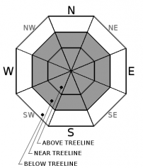
The avalanche danger is CONSIDERABLE above treeline and MODERATE near and below treeline. Variable winds have created the potential for windslabs 2-4ft deep on all aspects near and above treeline. Above treeline, human triggered wind slabs are likely and natural wind slabs are possible. Storm slabs remain a secondary concern as the snowpack continues to adjust to the weight of the new snow.


Avalanche Problem 1: Wind Slab
-
Character ?

-
Aspect/Elevation ?
-
Likelihood ?CertainVery LikelyLikelyPossible
 Unlikely
 -
Size ?HistoricVery LargeLargeSmall

Wind slabs may be found near treeline and above treeline on all aspects. Variable wind directions over the past few days have redistributed snow onto lee slopes and have cross loaded terrain features in these elevation bands. Today, wind slabs may be 2-4ft thick. Human triggered avalanches are likely above treeline on wind-loaded slopes steeper than 35 degrees. Natural avalanches are possible in upper elevation terrain as well.
Above treeline, Northwest and Southwest winds have been the primary force in transporting snow. Near treeline, evidence of Easterly winds has been most notable. In addition, local orographics create unusual wind eddies that can load other variable aspects and terrain features. Look for active wind transport of snow and pay attention to wind direction. Identify lee slopes and cross-loaded terrain features 35 degrees and steeper. Stick to wind sheltered areas, scoured slopes, and lower angle terrain to avoid the wind slab problem.
Avalanche Problem 2: Storm Slab
-
Character ?

-
Aspect/Elevation ?
-
Likelihood ?CertainVery LikelyLikelyPossible
Unlikely
-
Size ?HistoricVery LargeLargeSmall
A foot of new snow has recently been added to the snowpack. This new snow buried a variety of snow surfaces on December 23rd. Storm slabs now exist on all aspects and elevations and can take up to a few days to stabilize. The light new snow is becoming more cohesive and acting more like a slab. Natural storm slab avalanches are unlikely, but human triggered avalanches remain possible on slopes stepper than 35 degrees. Even though there have been no reports of avalanches, stability testing suggests that the snowpack is still adjusting to the to new snow. Today, dig down about a foot to assess how the new snow is bonding to the old snow surface. Direct your attention to weak snow that may exist just below a crust at this same depth.
Forecast Discussion
A foot of a new snow has created great skiing conditions. Cold temperatures have kept the snow light and dry. There have been no reports or observations of avalanches from this storm. Regardless, signs of instability are present and easy to identify. Variable winds are transporting snow and creating significant loading on lee slopes. The wind slab problem is certainly the primary concern today.
Overall, the storm snow seems to be bonding well to the old snow surface. However, weak snow has been found to exist just below a crust buried about a foot below the surface. Stability tests indicate the snowpack may still need time to adjust to the weight of the new snow.
Merry Christmas! Enjoy the sun and snow today and make sure to evaluate the snowpack carefully.
=============================================================
LOCAL AREA ROAD, NORDIC, AND SNOWMOBILE PARK STATUS:
The Sand Flat cross country ski trails are in good shape and ready for your cross country skis and snow shoes. These are backcountry routes marked with blue diamonds on trees. Trails are not groomed. Snow shoers, please blaze a parallel trail to cross country skiers staying out of the skin track. These trails can be accessed via the Everett Memorial Highway. Thank you, and enjoy!
The Mt. Shasta Nordic Center is OPEN for the season! Take advantage of this wonderful venue. Groomed trails accomodate both classic and skate skiing styles. Rentals available. Visit their website for more details. http://www.mtshastanordic.org
The Pilgrim Creek & Deer Mountain Snowmobile Parks are open, however there is no snow at these locations currently. One must drive down the 19 road (Military Pass) for several miles to get to consistent snow before unloading. Private industry is logging out there so watch out for log trucks. Head to our "Education" tab on our website and find the snowmobile section for trail information, grooming status, and other sledder resources.
The Castle Lake Road is OPEN. The Everett Memorial Highway is OPEN. The Castle Lake and Everett Hwy are plowed year round to the trailheads. The roads are not always first priority, so your dawn patrol powder mission might be ceased if the plow has not made it up yet. Siskiyou County does a great job keeping the roads clear. Be respectful of the plow drivers if you encounter them. If you get to Bunny Flat before or during when the plow is there, please park on the uphill, LEFT side of the parking lot as you drive in. This is uphill and lookers right of the bathrooms. Thank You!
The Five Red Flags of Avalanche Danger any time of year include: 1) Recent/current avalanche activity 2) Whumphing sounds or shooting cracks 3) Recent/current heavy snowfall 4) Strong winds transporting snow 5) Rapid warming or rain on snow.
Recent Observations
12” of new snow has been added to the snowpack from the storm beginning on December 23rd. New snow totals are less below 6500ft. Yesterday, during a tour from the Ski Park to the Grey Butte Weather Station, evidence of variable wind activity was observed. Near and below treeline, Easterly winds have been the driving force in transporting snow on to westerly aspects. Above treeline, winds have played a much more significant role in redistributing snow and have been primarily Northwesterly. Significant blowing of snow was observed yesterday above treeline and in upper elevation terrain. Pillows of loaded snow and wind slabs 3ft deep were seen (see photo in Observations), and blowing snow covered ski tracks between laps.
There are no recent observations or reports of avalanches. However, a number a shooting cracks and notable stability test results were observed yesterday, all occurring at the old snow/new snow interface that was buried on December 23rd. In addition, the new snow is becoming much more cohesive.
A test pit was dug on an ENE slope at 7800ft below the Grey Butte Weather Station targeting the December 23rd interface. At this location, the old snow surface was burred a little over a foot below new snow. In all stability tests, failure occurred on the December 23rd interface on a layer of rounding facets sitting just below a crust. All extended column tests resulted in full propagation with moderate force on this layer (see photo in Observations). Compression tests failed with sudden collapse fractures.
Weather and Current Conditions
Weather Summary
Very cold temperatures were recorded overnight at all of our remote weather stations with lows in the teens and single digits. Cold temperatures will continue today with highs around 20 degrees F. Skies will be sunny and clear. Variable winds will continue as well. Lower elevations will see calm easterly winds, while 10,000ft and above should see steady, strong Northwest winds. Skies will remain clear overnight and into Monday morning before a flat westerly jetstream brings another pacific front toward the coast. Increasing cloud cover is expected, as well as a slight chance of precipitation.
============================================================
In Mt Shasta City at 0500, we have a current temperature of 14 F.
On Mt Shasta (South Side) in the last 24 hours...
Old Ski Bowl - 7,600 feet, the current temperature is 8 degrees F. Snow on the ground totals 80 inches with 2 inches of new snow. Temperatures have ranged from 8F to 20F.
Grey Butte - 8,000 feet, the current temperature is 8 degrees F. Temperatures have ranged from 8 F to 19F. Winds have been variable, mostly blowing out of the SE averaging 1-6 mph, with gusts as high as 14 mph.
Mt Eddy Range (West side of Interstate-5)...
Castle Lake - 5,600 feet, the current temperature is 14 degrees F. Temperatures have ranged from 14 F to 19 F. Snow on the ground totals 29 inches with 2 inches of new snow.
Mt Eddy - 6,500 feet, the current temperature is 6 degrees F. Temperatures have ranged from 6 F to 21 F. Snow on the ground measures 34 inches with 2 inches of settlment Winds have averaged 1-4 mph with gusts to 13 mph, blowing from the Southeast and shifting Southwest.
THIS SEASON PRECIPITATION for MT SHASTA CITY: Since October 1st (the wet season), we have received 21.11 inches of water, normal is 13.41 inches, putting us at 157% of normal. For the month of December we received 4.64 inches of water, normal is 6.05 inches, putting us at 77% of normal, and finally... for the year of 2016 we've received 54.01 inches of water, normal is 41.41 inches, putting us at 130% of normal.
Always check the weather before you attempt to climb Mt Shasta. Further, monitor the weather as you climb. Becoming caught on the mountain in any type of weather can compromise life and limb. Be prepared.
| 0600 temperature: | 2 |
| Max. temperature in the last 24 hours: | 22 |
| Average wind direction during the last 24 hours: | Southeast |
| Average wind speed during the last 24 hours: | 1-5 mi/hr |
| Maximum wind gust in the last 24 hours: | 14 mi/hr |
| New snowfall in the last 24 hours: | 0 inches |
| Total snow depth: | 43 inches |
Two Day Mountain Weather Forecast
Produced in partnership with the Medford NWS
| For 7000 ft to 9000 ft | |||
|---|---|---|---|
|
Sunday (4 a.m. to 10 p.m.) |
Sunday Night (10 p.m. to 4 a.m.) |
Monday (4 a.m. to 10 p.m.) |
|
| Weather | Sunny. Calm Northwest wind becoming light and variable. | Mostly clear. | Mostly sunny |
| Temperature (°F) | 20 | 10 | 28 |
| Wind (mi/hr) | Northwest 5 mph | East 5 mph | East/Northeast becoming South 5 mph |
| Precipitation SWE / Snowfall (in) | / 0 | / 0 | / 0 |
| For 9000 ft to 11000 ft | |||
| Sunday | Sunday Night | Monday | |
| Weather | Sunny and Windy. | Mostly Clear and Windy. | Mostly Sunny and Windy. |
| Temperature (°F) | 15 | 15 | 26 |
| Wind (mi/hr) | West 30-35 mph | Northwest 0 | Northwest 25-30 mph, 40 mph gusts |
| Precipitation SWE / Snowfall (in) | / 0 | / 0 | / 0 |

