

You are here
Avalanche Advisory for 2016-12-26 06:55:37
- EXPIRED ON December 27, 2016 @ 6:55 amPublished on December 26, 2016 @ 6:55 am
- Issued by Andrew Kiefer - Mt Shasta Avalanche Center
Bottom Line
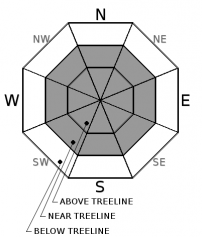
The avalanche danger is MODERATE above treeline and near treeline. LOW avalanche danger exists below treeline. Wind slabs are the primary avalanche concern. On all aspects near and above treeline, wind slabs 2-4ft thick may exist. Today, human triggered avalanches are possible, and natural avalanches are unlikely.


Avalanche Problem 1: Wind Slab
-
Character ?

-
Aspect/Elevation ?
-
Likelihood ?CertainVery LikelyLikelyPossible
 Unlikely
 -
Size ?HistoricVery LargeLargeSmall

Wind slabs may be found near treeline and above treeline on all aspects. Variable wind directions have loaded lee slopes and cross-loaded terrain features. In these areas of loaded snow, wind slabs 2-4ft deep exist. Today, human triggered wind slab avalanches are possible. Natural avalanches are unlikely.
Near and above treeline, the wind slab problem exists in specific areas. Variable winds have redistributed snow unevenly throughout the terrain. Look for active wind transport of snow and pay attention to wind direction. Transitions from scoured hard snow to soft deep snow, pillows of loaded snow, and textured snow surfaces may all be good indications of the wind slab presence. Identify these conditions on terrain features 35 degrees and steeper. Wind slabs are most likely to be triggered on terrain steeper than 35 degrees just below ridgelines, on convex rollovers, and on unsupported slopes.
Forecast Discussion
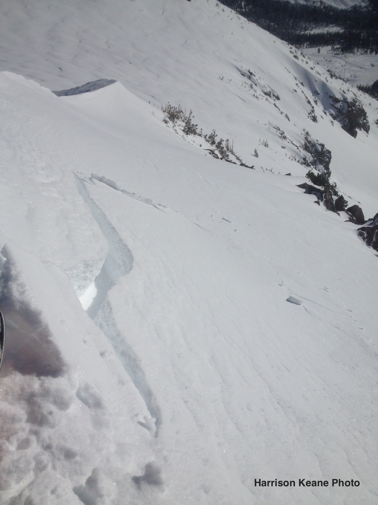
No avalanches have been reported in the advisory area recently. A notable shooting crack occurred on a Southeast slope above treeline yesterday. See observations below.
The wind slab problem remains the primary concern. Evidence of wind transport yesterday was observed above treeline, and snowpack loading continues. Wind direction has been variable, but winds have blown steadily above 9,000ft. Winds are expected to increase today and tomorrow.
The recent storm snow is settling and bonding well to the old snow surface in lower elevation terrain and areas protected from the wind. Cold temperatures have kept the snow dry and light, and the skiing and riding conditions are very good. If you venture into the backcountry today, make sure to evaluate snow and terrain carefully and identify features of concern.
=============================================================
LOCAL AREA ROAD, NORDIC, AND SNOWMOBILE PARK STATUS:
The Sand Flat cross country ski trails are in good shape and ready for your cross country skis and snow shoes. These are backcountry routes marked with blue diamonds on trees. Trails are not groomed. Snow shoers, please blaze a parallel trail to cross country skiers staying out of the skin track. These trails can be accessed via the Everett Memorial Highway. Thank you, and enjoy!
The Mt. Shasta Nordic Center is OPEN for the season! Take advantage of this wonderful venue. Groomed trails accomodate both classic and skate skiing styles. Rentals available. Visit their website for more details. http://www.mtshastanordic.org
The Pilgrim Creek & Deer Mountain Snowmobile Parks are open, however there is no snow at these locations currently. One must drive down the 19 road (Military Pass) for several miles to get to consistent snow before unloading. Private industry is logging out there so watch out for log trucks. Head to our "Education" tab on our website and find the snowmobile section for trail information, grooming status, and other sledder resources.
The Castle Lake Road is OPEN. The Everett Memorial Highway is OPEN. The Castle Lake and Everett Hwy are plowed year round to the trailheads. The roads are not always first priority, so your dawn patrol powder mission might be ceased if the plow has not made it up yet. Siskiyou County does a great job keeping the roads clear. Be respectful of the plow drivers if you encounter them. If you get to Bunny Flat before or during when the plow is there, please park on the uphill, LEFT side of the parking lot as you drive in. This is uphill and lookers right of the bathrooms. Thank You!
The Five Red Flags of Avalanche Danger any time of year include: 1) Recent/current avalanche activity 2) Whumphing sounds or shooting cracks 3) Recent/current heavy snowfall 4) Strong winds transporting snow 5) Rapid warming or rain on snow.
Recent Observations
A large crack propagated out onto a steep southeast slope above treeline from beneath a skier touring on a ridgeline yesterday. This evidence shows that unstable wind slabs exist on lee slopes above treeline and can be human triggered.
Cold temperatures kept the snow dry and light yesterday. Winds were calm below 9,000ft. Near and above this elevation, evidence of wind transport was observed. Loaded snow and winds slabs were visible on all aspects above treeline. The wind slab problem exists in pockets and is confined to specific slopes and terrain features.
No recent avalanches have been observed. Results from a test pit dug on a Southeast slope near treeline showed that the new snow is bonding well to the old snow surface. Stability tests targeting the new snow/old snow interface at this location showed no propagation and resistant planar fractures.
Weather and Current Conditions
Weather Summary
Cold temperatures and mostly sunny skies continue this morning. Temperatures will reach a high of 30 degrees this afternoon. Winds will remain light below 9,000ft blowing out of the Southeast. Upper elevations will see West/Northwest winds blowing steady at 20-30mph, and increasing to high speeds tonight and tomorrow. A frontal system approaches the area tonight, bringing cloudy skies and a slight chance for snow. Mount Shasta may receive a trace of new snow tomorrow, but confidence is low. Significant snowfall is expected as far south as Crater Lake tonight through Tuesday, just missing our advisory area.
============================================================
In Mt Shasta City at 0500, we have a current temperature of 11 F.
On Mt Shasta (South Side) in the last 24 hours...
Old Ski Bowl - 7,600 feet, the current temperature is 16 degrees F. Snow on the ground totals 78 inches with 2 inches of settlement. Temperatures have ranged from 8F to 21F.
Grey Butte - 8,000 feet, the current temperature is 13 degrees F. Temperatures have ranged from 8 F to 18F. Winds have blown out of the Southeast averaging 1-6 mph, with gusts as high as 14 mph.
Mt Eddy Range (West side of Interstate-5)...
Castle Lake - 5,600 feet, the current temperature is 18 degrees F. Temperatures have ranged from 14 F to 20 F. Snow on the ground totals 28 inches with 1 inch of settlement.
Mt Eddy - 6,500 feet, the current temperature is 11 degrees F. Temperatures have ranged from 7 F to 21 F. Snow on the ground measures 34 inches with little settlment. Winds have averaged 1-4 mph with gusts to 6 mph, blowing from the Southwest.
THIS SEASON PRECIPITATION for MT SHASTA CITY: Since October 1st (the wet season), we have received 21.11 inches of water, normal is 13.67 inches, putting us at 154% of normal. For the month of December we received 4.64 inches of water, normal is 6.31 inches, putting us at 74% of normal, and finally... for the year of 2016 we've received 54.01 inches of water, normal is 41.67 inches, putting us at 130% of normal.
Always check the weather before you attempt to climb Mt Shasta. Further, monitor the weather as you climb. Becoming caught on the mountain in any type of weather can compromise life and limb. Be prepared.
| 0600 temperature: | 5 |
| Max. temperature in the last 24 hours: | 20 |
| Average wind direction during the last 24 hours: | Southeast |
| Average wind speed during the last 24 hours: | 1-5 mi/hr |
| Maximum wind gust in the last 24 hours: | 14 mi/hr |
| New snowfall in the last 24 hours: | 0 inches |
| Total snow depth: | 41 inches |
Two Day Mountain Weather Forecast
Produced in partnership with the Medford NWS
| For 7000 ft to 9000 ft | |||
|---|---|---|---|
|
Monday (4 a.m. to 10 p.m.) |
Monday Night (10 p.m. to 4 a.m.) |
Tuesday (4 a.m. to 10 p.m.) |
|
| Weather | Sunny. | Slight Chance of Snow | Chance of Snow Showers and Breezy then becoming Partly Sunny |
| Temperature (°F) | 29 | 20 | 34 |
| Wind (mi/hr) | Northeast becoming South 5-10 mph | West becoming Southwest 10-15 mph | West 15-20 mph |
| Precipitation SWE / Snowfall (in) | / 0 | / 0 | / 0 |
| For 9000 ft to 11000 ft | |||
| Monday | Monday Night | Tuesday | |
| Weather | Sunny and Blustery. | Slight Chance Snow and Windy. | Chance of Snow and Windy. |
| Temperature (°F) | 24 | 21 | 24 |
| Wind (mi/hr) | West/Northwest 20-25 mph | West 0 | West 40-50 mph, 70-80 mph gusts |
| Precipitation SWE / Snowfall (in) | / 0 | / 0 | / 0 |

