

You are here
Avalanche Advisory for 2016-12-27 06:50:35
- EXPIRED ON December 28, 2016 @ 6:50 amPublished on December 27, 2016 @ 6:50 am
- Issued by Andrew Kiefer - Mt Shasta Avalanche Center
Bottom Line
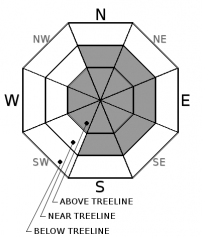
The avalanche danger is MODERATE above treeline and near treeline. LOW avalanche danger exists below treeline. Wind slabs are the primary concern and are most likely to be found on N-NE-E-SE-S aspects. Wind slabs may be 2-4ft thick. Human triggered avalanches remain possible, and natural avalanches are unlikely.


Avalanche Problem 1: Wind Slab
-
Character ?

-
Aspect/Elevation ?
-
Likelihood ?CertainVery LikelyLikelyPossible
 Unlikely
 -
Size ?HistoricVery LargeLargeSmall

Today, wind speeds will ramp up and wind direction will organize, blowing from the west. This will be a noticeable change following several days of calm and variable winds. Wind slabs are the primary avalanche concern, and can be found above treeline on all aspects and near treeline on N-NE-E-SE-S facing aspects.
A natural wind slab avalanche is unlikely today, but human triggering remains a concern. Transitions from scoured hard snow to soft deep snow, pillows of loaded snow, and textured snow surfaces may all be good indications of the wind slab presence. Wind slabs are most likely to be triggered on slopes steeper than 35 degrees just below ridgelines, on convex rollovers, and on unsupported terrain features.
Forecast Discussion
No avalanches have been reported in several days. The recent storm snow is settling and bonding well to the old snow surface in lower elevation terrain and areas protected from the wind. Cold temperatures have kept the snow dry and light, and the skiing and riding conditions are good. Temperatures are warming, but winds may keep it feeling cold in the mountains today. If you venture into the backcountry, be sure to evaluate snow and terrain carefully and identify features of concern.
With increased westerly winds and snow available for transport, the wind slab problem remains a concern. The distribution of wind slabs has been variable near and above treeline. Today, wind slab development is likely to continue, and the distribution of the problem may become more organized to easterly aspects.
=============================================================
LOCAL AREA ROAD, NORDIC, AND SNOWMOBILE PARK STATUS:
The Sand Flat cross country ski trails are in good shape and ready for your cross country skis and snow shoes. These are backcountry routes marked with blue diamonds on trees. Trails are not groomed. Snow shoers, please blaze a parallel trail to cross country skiers staying out of the skin track. These trails can be accessed via the Everett Memorial Highway. Thank you, and enjoy!
The Mt. Shasta Nordic Center is OPEN for the season! Take advantage of this wonderful venue. Groomed trails accomodate both classic and skate skiing styles. Rentals available. Visit their website for more details. http://www.mtshastanordic.org
The Pilgrim Creek & Deer Mountain Snowmobile Parks are open, however there is no snow at these locations currently. One must drive down the 19 road (Military Pass) for several miles to get to consistent snow before unloading. Private industry is logging out there so watch out for log trucks. Head to our "Education" tab on our website and find the snowmobile section for trail information, grooming status, and other sledder resources.
The Castle Lake Road is OPEN. The Everett Memorial Highway is OPEN. The Castle Lake and Everett Hwy are plowed year round to the trailheads. The roads are not always first priority, so your dawn patrol powder mission might be ceased if the plow has not made it up yet. Siskiyou County does a great job keeping the roads clear. Be respectful of the plow drivers if you encounter them. If you get to Bunny Flat before or during when the plow is there, please park on the uphill, LEFT side of the parking lot as you drive in. This is uphill and lookers right of the bathrooms. Thank You!
The Five Red Flags of Avalanche Danger any time of year include: 1) Recent/current avalanche activity 2) Whumphing sounds or shooting cracks 3) Recent/current heavy snowfall 4) Strong winds transporting snow 5) Rapid warming or rain on snow.
Recent Observations
A shooting crack caused by a ski test on a pocket of wind slab has been a recent sign of instability. During the past few days, winds have been pleasantly calm up to 9,000ft. The new snow has settled 2-3inches, and ski quality has been very good.
The cold and calm conditions have kept the snow light and dry. For that reason, plenty of snow is still available for wind transport. Wind directions recently have been variable, and the presence of the wind slab problem has mostly been confined to above treeline terrain.
The snowpack on some cold, shady, northerly aspects near and above treeline has presented with a layer of weaker snow buried about 1 foot deep sitting below a crust. No avalanches have failed on this layer, but it has produced unstable results in stability tests. This layer (12/23) continues to heal and it is not a problem right now. However, it is worth keeping an eye on, especially if more snow/weight is added to the snowpack soon.
Weather and Current Conditions
Weather Summary
Strong westerly flow will bring mostly cloudy skies and high winds above the 10,000ft level today on Mount Shasta. A winter storm is passing just North of Siskiyou County. A Winter Weather Advisory has been issued for the Crater Lake area, which is expecting heavy snowfall in the next 24 hours. In our advisory area, we have a chance of receiving a trace– 1 inch of snow by tomorrow morning but confidence that these totals will verify is low. Westerly winds will increase throughout the day, with gusts 40-50mph. Temperatures for the 6,000ft level are expected to reach the high 30’s today.
============================================================
In Mt Shasta City at 0500, we have a current temperature of 22 F.
On Mt Shasta (South Side) in the last 24 hours...
Old Ski Bowl - 7,600 feet, the current temperature is 33 degrees F. Snow on the ground totals 76 inches with 2 inches of settlement. Temperatures have ranged from 15 F to 35 F.
Grey Butte - 8,000 feet, the current temperature is 31 degrees F. Temperatures have ranged from 19 F to 34F. Winds have blown out of the Northwest, increasing overnight to 20-30 mph, with gusts as high as 35 mph.
Mt Eddy Range (West side of Interstate-5)...
Castle Lake - 5,600 feet, the current temperature is 32 degrees F. Temperatures have ranged from 17 F to 32 F. Snow on the ground totals 28 inches with little settlement.
Mt Eddy - 6,500 feet, the current temperature is 33 degrees F. Temperatures have ranged from 12 F to 33 F. Snow on the ground measures 31 inches with 3 inches of settlment. Winds have averaged 1-5 mph with gusts to 6 mph, blowing from the Southwest.
THIS SEASON PRECIPITATION for MT SHASTA CITY: Since October 1st (the wet season), we have received 21.11 inches of water, normal is 13.93 inches, putting us at 152% of normal. For the month of December we received 4.64 inches of water, normal is 6.57 inches, putting us at 71% of normal, and finally... for the year of 2016 we've received 54.01 inches of water, normal is 41.93 inches, putting us at 129% of normal.
Always check the weather before you attempt to climb Mt Shasta. Further, monitor the weather as you climb. Becoming caught on the mountain in any type of weather can compromise life and limb. Be prepared.
| 0600 temperature: | 29 |
| Max. temperature in the last 24 hours: | 30 |
| Average wind direction during the last 24 hours: | Northwest |
| Average wind speed during the last 24 hours: | 10-15 mi/hr |
| Maximum wind gust in the last 24 hours: | 20 mi/hr |
| New snowfall in the last 24 hours: | 0 inches |
| Total snow depth: | 41 inches |
Two Day Mountain Weather Forecast
Produced in partnership with the Medford NWS
| For 7000 ft to 9000 ft | |||
|---|---|---|---|
|
Tuesday (4 a.m. to 10 p.m.) |
Tuesday Night (10 p.m. to 4 a.m.) |
Wednesday (4 a.m. to 10 p.m.) |
|
| Weather | Chance Snow Showers. Breezy. | Chance Snow Showers. Breezy. | Mostly Sunny. |
| Temperature (°F) | 34 | 23 | 37 |
| Wind (mi/hr) | South/Southwest 20-30 mph | Northwest 25 mph | Northeast 10-15 mph |
| Precipitation SWE / Snowfall (in) | / .5 | / .5 | / 0 |
| For 9000 ft to 11000 ft | |||
| Tuesday | Tuesday Night | Wednesday | |
| Weather | Slight Chance of Snow. Windy | Slight Chance Snow. Windy. | Mostly Sunny. |
| Temperature (°F) | 26 | 24 | 27 |
| Wind (mi/hr) | West 50-60 mph, Gusting 70-80 mph | West/Northwest .5 | West 40-50 mph, |
| Precipitation SWE / Snowfall (in) | / .5 | / .5 | / 0 |

