

You are here
Avalanche Advisory for 2016-12-29 06:47:21
- EXPIRED ON December 30, 2016 @ 6:47 amPublished on December 29, 2016 @ 6:47 am
- Issued by Nick Meyers - Shasta-Trinity National Forest
Bottom Line
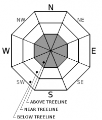
For today, LOW avalanche danger exists for all aspects and elevations within the forecast area. A 48 hour northwest wind event has left the snowpack primarily wind scoured. Variable conditions prevail. Small, isolated wind slabs may linger on select terrain features above 10,000 feet in alpine terrain where cold temperatures and wind have sustained. Use normal caution.
Climbers, beware of firm and smooth snow surface conditions. A slide for life will occur without quick self arrest.


Avalanche Problem 1: Wind Slab
-
Character ?

-
Aspect/Elevation ?
-
Likelihood ?CertainVery LikelyLikelyPossible
 Unlikely
 -
Size ?HistoricVery LargeLargeSmall

Overall, the snowpack stability is good. Still, take caution on steep slopes (>37 degrees) in alpine terrain where windy and cold temperatures have sustained and lingering, small wind slabs may still exist. Unsupported slopes along ridgelines, near rock outcrops, gullies and depressions above 10,000 feet could still host the odd unstable wind slab. That said, overall it is unlikely that a skier or rider triggered wind slab will occur today. Use normal caution, be able to identify terrain features of concern and the absence or presence of wind slabs. Continue to use safe travel precautions.
Forecast Discussion
Inversions are in place this morning as we recover from a breezy 48 hour, northwest wind event. This wind coupled with sunny skies has returned the backcountry to variable skiing and riding conditions. Signs of instability and recent avalanches have been hard to come by. Much of the light density snow from our pre-Christmas storm simply blew off the mountain over the past couple days. Several inches of snow settlement has occured within the snowpack and snowpit tests have indicated good stability. Existing ski and snowmobile tracks remain as skeletons in the closet as wind has eroded and sculpted the landscape, exposing tracks and creating wild sastrugi features. Some areas are scoured, firm and icy. Indeed you can still find some soft powder snow, but you will also likely encounter breakable crust and everything in between. Climbers beware of the long slide for life without quick self arrest skills in the event of a fall. No matter what time of year, ski and ride one at a time in avalanche terrain. Limit the number exposed to a potential avalanche. Don't regroup in avalanche run out zones. Don't expose others to risk with out their consent.
=============================================================
LOCAL AREA ROAD, NORDIC, AND SNOWMOBILE PARK STATUS:
The Sand Flat cross country ski trails are in good shape and ready for your cross country skis and snow shoes. These are backcountry routes marked with blue diamonds on trees. Trails are not groomed. Snow shoers, please blaze a parallel trail to cross country skiers staying out of the skin track. These trails can be accessed via the Everett Memorial Highway. Thank you, and enjoy!
The Mt. Shasta Nordic Center is OPEN for the season! Take advantage of this wonderful venue. Groomed trails accomodate both classic and skate skiing styles. Rentals available. Visit their website for more details. http://www.mtshastanordic.org
The Pilgrim Creek & Deer Mountain Snowmobile Parks are open, however there is no snow at these locations currently. One must drive down the 19 road (Military Pass) for several miles to get to consistent snow before unloading. Private industry is logging out there so watch out for log trucks. Head to our "Education" tab on our website and find the snowmobile section for trail information, grooming status, and other sledder resources.
The Castle Lake Road is OPEN. The Everett Memorial Highway is OPEN. The Castle Lake and Everett Hwy are plowed year round to the trailheads. The roads are not always first priority, so your dawn patrol powder mission might be ceased if the plow has not made it up yet. Siskiyou County does a great job keeping the roads clear. Be respectful of the plow drivers if you encounter them. If you get to Bunny Flat before or during when the plow is there, please park on the uphill, LEFT side of the parking lot as you drive in. This is uphill and lookers right of the bathrooms. Thank You!
The Five Red Flags of Avalanche Danger any time of year include: 1) Recent/current avalanche activity 2) Whumphing sounds or shooting cracks 3) Recent/current heavy snowfall 4) Strong winds transporting snow 5) Rapid warming or rain on snow.
Recent Observations
Observations were made from Bunny Flat, Broadway area and the Old Ski Bowl area up to 9,200 feet yesterday (See pit profile below). A dawn patroler noted "death cookie crust", hard slabs followed by soft wind pillows and overall challenging ski conditions on the south side of Mt Shasta. Shooting cracks were observed within new hard slabs by the same skier along their tour up Broadway...exact location unknown. Observations up in the Old Ski Bowl noted a wind affected snowpack: wild sastrugi features, smooth areas with an icy sheen, breakable crust, semi-smooth hard slabs and pockets of soft powder near and below treeline. A few sun induced roller balls were observed on an east aspect below treeline. Easterly aspects and leeward gullies above treeline had notable wind loading. No recent avalanches have been observed.
On a shaded northerly aspect above treeline, we checked in with our 12/23 layer of weaker snow buried about 1 foot deep, just below a crust. No avalanches have failed on this layer, but it still is producing sudden planar fracture characteristics from small column tests. Large column tests have not been able to produce propagation. This layer of weaker (rounding faceted) snow will be monitored. Snowpit tests still indicate the presence of the layer, though with a healing trend occuring overall. It would take signifcant loading of this layer to cause concern at this point.
Weather and Current Conditions
Weather Summary
High pressure will stick behind the wheel and remain in control for today. Expect strong inversions and air stagnation in the valleys across Southern Siskiyou County. This will persist through Thursday until our next change in weather conditions. Friday, a cold front will begin a cooling trend. A much colder air mass will take over the Pacific Northwest on Saturday and bring precipitation down to low elevations. Precip amounts are uncertain at this time however, what snow does fall is likely to stick around as low tempeatures could be record setting for this time of year. More details on the weekend later. For today, your hostess will serve sunny skies and calm winds...enjoy!
============================================================
In Mt Shasta City at 0500, we have a current temperature of 25 F.
On Mt Shasta (South Side) in the last 24 hours...
Old Ski Bowl - 7,600 feet, the current temperature is 44 degrees F. Snow on the ground totals 73 inches with 1 inch of settlement. Temperatures have ranged from 27 F to 44 F.
Grey Butte - 8,000 feet, the current temperature is 42 degrees F. Temperatures have ranged from 29 F to 42F. Winds blew out of the northwest 20-30 mph with gusts to 50 mph up until 0900 and then calmed considerably, averaging 5-10 mph, variable in direction.
Mt Eddy Range (West side of Interstate-5)...
Castle Lake - 5,600 feet, the current temperature is 24 degrees F. Temperatures have ranged from 23 F to 42 F. Snow on the ground totals 26 inches with little settlement.
Mt Eddy - 6,500 feet, the current temperature is 35 degrees F. Temperatures have ranged from 24 F to 42 F. Snow on the ground measures 31 inches with little settlment. Winds have averaged 3-4 mph with gusts to 7 mph, west/southwest.
THIS SEASON PRECIPITATION for MT SHASTA CITY: Since October 1st (the wet season), we have received 21.11 inches of water, normal is 14.45 inches, putting us at 146% of normal. For the month of December we received 4.64 inches of water, normal is 7.09 inches, putting us at 65% of normal, and finally... for the year of 2016 we've received 54.01 inches of water, normal is 42.45 inches, putting us at 127% of normal.
Always check the weather before you attempt to climb Mt Shasta. Further, monitor the weather as you climb. Becoming caught on the mountain in any type of weather can compromise life and limb. Be prepared.
| 0600 temperature: | 29 |
| Max. temperature in the last 24 hours: | 37 |
| Average wind direction during the last 24 hours: | NW --> VAR |
| Average wind speed during the last 24 hours: | 5-10 mi/hr |
| Maximum wind gust in the last 24 hours: | 15 mi/hr |
| New snowfall in the last 24 hours: | 0 inches |
| Total snow depth: | 41 inches |
Two Day Mountain Weather Forecast
Produced in partnership with the Medford NWS
| For 7000 ft to 9000 ft | |||
|---|---|---|---|
|
Thursday (4 a.m. to 10 p.m.) |
Thursday Night (10 p.m. to 4 a.m.) |
Friday (4 a.m. to 10 p.m.) |
|
| Weather | Sunny | Mostly clear | Mostly sunny |
| Temperature (°F) | 44 | 26 | 38 |
| Wind (mi/hr) | Southeast 5-10 mph | East 5-10 mph | Northwest 5-10 mph |
| Precipitation SWE / Snowfall (in) | / 0 | / 0 | / 0 |
| For 9000 ft to 11000 ft | |||
| Thursday | Thursday Night | Friday | |
| Weather | Sunny | Mostly clear | Mostly sunny |
| Temperature (°F) | 32 | 26 | 18 |
| Wind (mi/hr) | West/Southwest 10-15 mph | West/Southwest 0 | West 20-25 mph |
| Precipitation SWE / Snowfall (in) | / 0 | / 0 | / 0 |

