

You are here
Avalanche Advisory for 2017-01-01 06:56:29
- EXPIRED ON January 2, 2017 @ 6:56 amPublished on January 1, 2017 @ 6:56 am
- Issued by Nick Meyers - Shasta-Trinity National Forest
Bottom Line
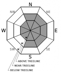
LOW avalanche danger exists on all aspects and elevations this morning. Expect increasing wind slab avalanche danger near and above treeline today with potential MODERATE danger late this afternoon as new wind slabs form. Watch for unstable snow on isolated features in mid and upper elevation terrain. Be aware of firm and icy snow surfaces. A slide for life could occur on steep slopes without immediate self-arrest.


Avalanche Problem 1: Wind Slab
-
Character ?

-
Aspect/Elevation ?
-
Likelihood ?CertainVery LikelyLikelyPossible
 Unlikely
 -
Size ?HistoricVery LargeLargeSmall

Very good snowpack stability exists as of this morning, however this will change today. Expect increasing avalanche danger as a cold winter storm brings new snow and wind to the forecast area. Wind can load snow onto leeward slopes 10 times faster than snow falling from the sky. About 1-3 inches of new snow is expected today. Areas of concern will lie above treeline during the afternoon hours when new snow has had time to be transported and loaded on leeward slopes.
No matter what time of year or what the avalanche danger is, remember: Don't go into the backcountry until you get the proper gear and training. Ski and ride one at a time in avalanche terrain. Limit the number exposed to a potential avalanche. Don't re-group in avalanche paths or in run out zones! Stay out of harm's way and always work to reduce your exposure to risk. Pay attention to who is below you AND above you. Promote and teach good backcountry etiquette for others to follow... because others WILL follow! We should always strive to hold ourselves to a high standard in the mountains.
Forecast Discussion
A winter storm will impact the area over the next several days. Expect a steady trickle of snow with periods of heavier precipitation. Moderate west/southwest wind are expected with this storm. The avalanche danger will increase with new snow and wind loading. Previous snow surfaces are variable: scoured, icy hard pack, firm and chalky wind packed snow, undulating sastrugi features and pockets of softer snow. Temperatures will drop drastically today as we are already seeing and serious cold, winter conditions will prevail on the mountain.
Are there any climbers out there? Very smooth and firm conditions exist on many of Shasta's climbing routes. This is a serious issue to consider if you are a novice climber. A slip/fall and failure to self-arrest will quickly result in a long slide for life. Solid self-arrest skills are mandatory. Further, conditions on the mountain for the next several days will be SEVERE. Whiteout conditions, extreme cold and wind chill, potential avalanche danger, high winds.... take warning, be prepared.
=============================================================
LOCAL AREA ROAD, NORDIC, AND SNOWMOBILE PARK STATUS:
The Sand Flat cross country ski trails are in good shape and ready for your cross country skis and snow shoes. These are backcountry routes marked with blue diamonds on trees. Trails are not groomed. Snow shoers, please blaze a parallel trail to cross country skiers staying out of the skin track. These trails can be accessed via the Everett Memorial Highway. Thank you, and enjoy!
The Mt. Shasta Nordic Center is OPEN for the season! Take advantage of this wonderful venue. Groomed trails accomodate both classic and skate skiing styles. Rentals available. Visit their website for more details. http://www.mtshastanordic.org
The Pilgrim Creek & Deer Mountain Snowmobile Parks are open, however there is no snow at these locations currently. One must drive down the 19 road (Military Pass) for several miles to get to consistent snow before unloading. Private industry is logging out there so watch out for log trucks. Head to our "Education" tab on our website and find the snowmobile section for trail information, grooming status, and other sledder resources.
The Castle Lake Road is OPEN. The Everett Memorial Highway is OPEN. The Castle Lake and Everett Hwy are plowed year round to the trailheads. The roads are not always first priority, so your dawn patrol powder mission might be ceased if the plow has not made it up yet. Siskiyou County does a great job keeping the roads clear. Be respectful of the plow drivers if you encounter them. If you get to Bunny Flat before or during when the plow is there, please park on the uphill, LEFT side of the parking lot as you drive in. This is uphill and lookers right of the bathrooms. Thank You!
The Five Red Flags of Avalanche Danger any time of year include: 1) Recent/current avalanche activity 2) Whumphing sounds or shooting cracks 3) Recent/current heavy snowfall 4) Strong winds transporting snow 5) Rapid warming or rain on snow.
Recent Observations
Snow surface conditions are variable. Wind scoured, firm, and icy conditions are widespread in upper elevation terrain requiring the use of an ice axe and crampons on steep slopes. In lower elevation terrain and on sun-exposed slopes, breakable crust exists. On shady slopes protected from the wind, cold soft snow still remains from the Christmas weekend storm. Throughout our entire advisory area, good coverage exists - 6,500ft and above holds a base of 2-3ft or more.
Temperatures have dropped significantly this morning, 10 degrees over a one hour period, as cold air pushes into the area.
Weather and Current Conditions
Weather Summary
A winter storm will usher in snow on the first day of 2017. A cold front and cold upper trough will move into the area today and will bring low elevation snow to much of the area today through Monday morning. Significant snow impacts are expected from the Cascades west today into tonight. As a surface low will move down the coast tonight and remain off the Southern Oregon coast Monday into Monday night while aloft an upper trough remains overhead. This pattern will result bring widespread showers tonight and Monday morning with continued low snow levels. Expect snow impacts to continue through at least Monday morning across western areas. Then additional light to moderate showers during the day Monday and Monday night are possible.
============================================================
In Mt Shasta City at 0500, we have a current temperature of 28 F.
On Mt Shasta (South Side) in the last 24 hours...
Old Ski Bowl - 7,600 feet, the current temperature is 20 degrees F. Snow on the ground totals 71 inches with no new snow and little settlement. Temperatures have ranged from 20 F to 41 F.
Grey Butte - 8,000 feet, the current temperature is 19 degrees F. Temperatures have ranged from 19 F to 40F. Winds have averaged 5-10 mph with gusts to 42 mph, variable in direction.
Mt Eddy Range (West side of Interstate-5)...
Castle Lake - 5,600 feet, the current temperature is 20 degrees F. Temperatures have ranged from 20 F to 37 F. Snow on the ground totals 26 inches with no new snow.
Mt Eddy - 6,500 feet, the current temperature is 18 degrees F. Temperatures have ranged from 18 F to 41 F. Snow on the ground measures 30 inches with no new snow. Winds have averaged 2 mph with gusts to 11 mph, variable in direction
THIS SEASON PRECIPITATION for MT SHASTA CITY: Since October 1st (the wet season), we have received 21.16 inches of water, normal is 15.21 inches, putting us at 139% of normal. For the month of December we received 4.69 inches of water, normal is 7.85 inches, putting us at 59% of normal, and finally... for the year of 2016 we've received 54.06 inches of water, normal is 43.21 inches, putting us at 125% of normal.
Always check the weather before you attempt to climb Mt Shasta. Further, monitor the weather as you climb. Becoming caught on the mountain in any type of weather can compromise life and limb. Be prepared.
| 0600 temperature: | 23 |
| Max. temperature in the last 24 hours: | 45 |
| Average wind direction during the last 24 hours: | Variable |
| Average wind speed during the last 24 hours: | 5-10 mi/hr |
| Maximum wind gust in the last 24 hours: | 15 mi/hr |
| New snowfall in the last 24 hours: | 0 inches |
| Total snow depth: | 40 inches |
Two Day Mountain Weather Forecast
Produced in partnership with the Medford NWS
| For 7000 ft to 9000 ft | |||
|---|---|---|---|
|
Sunday (4 a.m. to 10 p.m.) |
Sunday Night (10 p.m. to 4 a.m.) |
Monday (4 a.m. to 10 p.m.) |
|
| Weather | Snow showers. Temperature falling to around 16 by 4pm. Wind chill values as low as zero. Chance of precipitation is 100%. | Snow showers. Low around 11. Wind chill values as low as -5. Chance of precipitation is 90%. | Snow showers. High near 17. Wind chill values as low as -5. Chance of precipitation is 80%. |
| Temperature (°F) | 16 | 11 | 17 |
| Wind (mi/hr) | West 15-20 mph | Southwest 15-20 mph | South/Southwest 15-20 mph |
| Precipitation SWE / Snowfall (in) | / 1-3 | / 3-5 | / 4-8 |
| For 9000 ft to 11000 ft | |||
| Sunday | Sunday Night | Monday | |
| Weather | Snow showers. Temperature falling to around 0 by 5pm. Wind chill values as low as -31. Chance of precipitation is 100%. | Snow showers. Low around -4. Wind chill values as low as -35. Chance of precipitation is 80%. | Snow showers. High near -2. Wind chill values as low as -35. Chance of precipitation is 80%. |
| Temperature (°F) | 0 | -4 | -2 |
| Wind (mi/hr) | West 30-40 mph | West 1-3 | Southwest 30-40 mph |
| Precipitation SWE / Snowfall (in) | / 1-3 | / 3-5 | / 4-8 |

