

You are here
Avalanche Advisory for 2017-01-03 07:22:39
- EXPIRED ON January 4, 2017 @ 7:22 amPublished on January 3, 2017 @ 7:22 am
- Issued by Andrew Kiefer - Mt Shasta Avalanche Center
Bottom Line
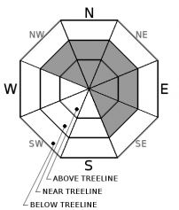
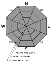
CONSIDERABLE avalanche danger exists on all aspects above treeline and near treeline. MODERATE avalanche danger exists below treeline. Wind Slabs avalanches near and above treeline on NW-N-NE-E-SE aspects are the primary concern. Storm Slab avalanches are also a concern. Natural avalanches are possible and human triggered avalanches are likely. Dangerous avalanche conditions exist in the backcountry. Careful snowpack evaluation, cautious route finding, and conservative decision-making are all essential today.


Avalanche Problem 1: Wind Slab
-
Character ?

-
Aspect/Elevation ?
-
Likelihood ?CertainVery LikelyLikelyPossible
 Unlikely
 -
Size ?HistoricVery LargeLargeSmall

Strong southwesterly winds and up to 10 inches of new snow have created wind slabs on lee slopes. Already, wind slabs could be 1-2ft thick. Southwest winds will continue, and additional new snow is expected in the next 24 hours. Winds slabs will grow in size and become more sensitive to trigger as the day progresses. Natural wind slab avalanches are possible and human triggered avalanches are likely today. The wind slab problem exists on NW-N-NE-E-SE aspects near treeline and above treeline. Loaded slopes 35 degrees and steeper are capable of producing a wind slab avalanche.
Avalanche Problem 2: Storm Slab
-
Character ?

-
Aspect/Elevation ?
-
Likelihood ?CertainVery LikelyLikelyPossible
Unlikely
-
Size ?HistoricVery LargeLargeSmall
With up to 10 inches of new snow in places already, and the possibility of 12 inches or more expected in the next 24 hours, storm slabs are a second avalanche problem today. The new snow is falling on a variety of old snow surfaces including firm and icy slopes, crusts, wind scoured areas, and cold powder snow. It will likely take time for the new snow to bond well to these variable surfaces. Storm slab development will increase throughout the day as more snow accumulates. Warmer temperatures today may add a more cohesive layer of snow on top of the cold, lighter snow from the past two days. Storm slabs are most likely in areas protected from the wind on all aspects and elevations.
Forecast Discussion
Avalanche danger is quickly rising in the backcountry today. Up to 10 inches of new snow has already fallen, and snowfall accumulation and rate are expected to peak during the next 24 hours. In addition to the heavy snowfall, strong southwest winds will continue, and temperatures will reach highs in the mid 20’s today.
Several inches of new snow and weight are being added to the snowpack. Steady southwest winds are blowing at speeds ideal for transporting snow. A warming trend is expected today and tomorrow. These are all significant red flags for avalanches. CONSIDERABLE avalanche danger exists above treeline and MODERATE avalanche danger exists below treeline.
In addition to the wind slab and storm slabs problems today, a potential persistent avalanche problem poses a significant concern. This may become an issue if the current storm adds enough snow and weight to the snowpack. On 12/23, a weak layer was buried by our last storm event, and now exists on cold, shady aspects (NW, N, NE, E) throughout the advisory area. This layer exists as rounding facets buried about one foot below the snow surface right now, and in many locations has been found to sit below a crust. No avalanches have occurred on this layer. Recent stability tests targeting this layer have been inconsistent, but have shown unstable results. On W, SW, S, SE slopes, the 12/23 layer does not present as weak snow and does not seem to pose a future problem.
=============================================================
LOCAL AREA ROAD, NORDIC, AND SNOWMOBILE PARK STATUS:
The Sand Flat cross country ski trails are in good shape and ready for your cross country skis and snow shoes. These are backcountry routes marked with blue diamonds on trees. Trails are not groomed. Snow shoers, please blaze a parallel trail to cross country skiers staying out of the skin track. These trails can be accessed via the Everett Memorial Highway. Thank you, and enjoy!
The Mt. Shasta Nordic Center is OPEN for the season! Take advantage of this wonderful venue. Groomed trails accomodate both classic and skate skiing styles. Rentals available. Visit their website for more details. http://www.mtshastanordic.org
The Pilgrim Creek & Deer Mountain Snowmobile Parks are open, however there is no snow at these locations currently. One must drive down the 19 road (Military Pass) for several miles to get to consistent snow before unloading. Private industry is logging out there so watch out for log trucks. Head to our "Education" tab on our website and find the snowmobile section for trail information, grooming status, and other sledder resources.
The Castle Lake Road is OPEN. The Everett Memorial Highway is OPEN. The Castle Lake and Everett Hwy are plowed year round to the trailheads. The roads are not always first priority, so your dawn patrol powder mission might be ceased if the plow has not made it up yet. Siskiyou County does a great job keeping the roads clear. Be respectful of the plow drivers if you encounter them. If you get to Bunny Flat before or during when the plow is there, please park on the uphill, LEFT side of the parking lot as you drive in. This is uphill and lookers right of the bathrooms. Thank You!
The Five Red Flags of Avalanche Danger any time of year include: 1) Recent/current avalanche activity 2) Whumphing sounds or shooting cracks 3) Recent/current heavy snowfall 4) Strong winds transporting snow 5) Rapid warming or rain on snow.
Recent Observations
Snowfall totals range from 2-10 inches in the past 24 hours with the Mount Eddy weather station recording the most snow. By 2pm yesterday, 5 inches of new snow was measured manually at the 8,000ft level on the south side of Mount Shasta. Visibility was low, and snowfall rates were 1” an hour between 12pm and 3pm before tapering off and becoming inconsistent overnight. In the avalanche gulch area yesterday afternoon, west/southwest winds were observed transporting the new snow and building wind slabs near and above treeline. Winds have been steady out of the west/southwest, averaging 15-25 MPH with gusts in the 40 MPH range at 8,000ft.
A test pit dug yesterday on a northwest slope at 7600ft near Giddy Giddy Gulch revealed the 12/23 layer to exist below a crust buried about 1ft below the surface. Small column tests produced sudden collapse results, while large column tests did not produce propagation on this layer. By 3pm yesterday in this area, the new snow was not yet showing slab characteristics.
Also yesterday, a shooting crack triggered by a skier occurred just below ridgeline near Ash Creek Butte in an area of wind-loaded snow. In addition, on the north side of Coyote Butte, sudden fractures occurred at the old snow/new snow interface and on the 12/23 layer in small column tests conducted yesterday.
Weather and Current Conditions
Weather Summary
A low-pressure system off of the Oregon Coast will continue to bring precipitation to our advisory area today. The National Weather Service has issued a Winter Storm Warning for Siskiyou County in effect for the next 24 hours.
In the past 24 hours, our remote weather stations recorded a range of 2-10 inches of new snow. Heavy snowfall is expected today and tomorrow as the next 24 hours are forecast to bring up to 1 inch of snow water equivalent (SWE) and 12 inches or more of snow. Uncertainly exists in exact snow totals during this time, but snowfall accumulation and rate will peak during next 24 hours. Snow levels will be 1000-2000ft. Temperatures will be warmer today, and highs will be around 25F. South/southwest winds will be steady, averaging 10-20 MPH with gusts to 30 MPH and gusts to 50+ MPH above 10,000ft.
===========================================================
In Mt Shasta City at 0500, we have a current temperature of 30 F with 2 inches of new snow.
On Mt Shasta (South Side) in the last 24 hours...
Old Ski Bowl - 7,600 feet, the current temperature is 14 degrees F. Temperatures have ranged from 7 F to 14 F. Snow on the ground totals 75 inches with 5 inches of new snow.
Grey Butte - 8,000 feet, the current temperature is 13 degrees F. Temperatures have ranged from 7 F to 13 F. Winds have averaged 15-25 mph with gusts to 42 mph, blowing from the west/southwest.
Mt Eddy Range (West side of Interstate-5)...
Castle Lake - 5,600 feet, the current temperature is 14 degrees F. Temperatures have ranged from 14 F to 20 F. Snow on the ground totals 34 inches with 6 inches of new snow.
Mt Eddy - 6,500 feet, the current temperature is 18 degrees F. Temperatures have ranged from 12 F to 18 F. Snow on the ground measures 42 inches with 10 inches of new snow. Winds have averaged 2 mph with gusts to 11 mph, blowing from the south/southwest.
THIS SEASON PRECIPITATION for MT SHASTA CITY: Since October 1st (the wet season), we have received 21.18 inches of water, normal is 15.69 inches, putting us at 135% of normal. For the month of January and for the year of 2017, we received .02 inches of water, normal is .48 inches, putting us at 4% of normal.
Always check the weather before you attempt to climb Mt Shasta. Further, monitor the weather as you climb. Becoming caught on the mountain in any type of weather can compromise life and limb. Be prepared.
| 0600 temperature: | 19 |
| Max. temperature in the last 24 hours: | 19 |
| Average wind direction during the last 24 hours: | West/southwest |
| Average wind speed during the last 24 hours: | 15-20 mi/hr |
| Maximum wind gust in the last 24 hours: | 40 mi/hr |
| New snowfall in the last 24 hours: | 2 inches |
| Total snow depth: | 41 inches |
Two Day Mountain Weather Forecast
Produced in partnership with the Medford NWS
| For 7000 ft to 9000 ft | |||
|---|---|---|---|
|
Tuesday (4 a.m. to 10 p.m.) |
Tuesday Night (10 p.m. to 4 a.m.) |
Wednesday (4 a.m. to 10 p.m.) |
|
| Weather | Heavy Snow. Chance of precipitation is 100%. | Heavy Snow and Windy. Chance of precipitation is 100%. | Snow and Breezy. Chance of precipitation is 100%. |
| Temperature (°F) | 24 | 22 | 28 |
| Wind (mi/hr) | South 10-15 mph | South/Southeast 20-30 mph | South 10-15 mph |
| Precipitation SWE / Snowfall (in) | / 6-12 | / 10-14 | / 3-7 |
| For 9000 ft to 11000 ft | |||
| Tuesday | Tuesday Night | Wednesday | |
| Weather | Heavy Snow and Windy. Chance of precipitation is 100%. | Heavy Snow and Windy. Chance of precipitation is 100%. | Snow and Windy. Chance of precipitation is mainly before 4pm. |
| Temperature (°F) | 19 | 11 | 11 |
| Wind (mi/hr) | South/Southwest 50-60 mph | Southwest 6-12 | West/Southwest 60-70 mph |
| Precipitation SWE / Snowfall (in) | / 6-12 | / 10-14 | / 3-7 |

