

You are here
Avalanche Advisory for 2017-01-05 06:42:50
- EXPIRED ON January 6, 2017 @ 6:42 amPublished on January 5, 2017 @ 6:42 am
- Issued by Nick Meyers - Shasta-Trinity National Forest
Bottom Line
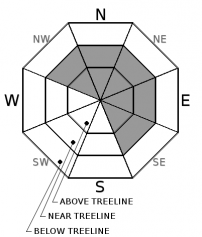
Wind slabs, storm slabs and persistent slabs continue to present a complex mix of avalanche problems today. Expect overall MODERATE danger for all elevations on W-SW-S-SE facing slopes. For NW-N-NE-E facing slopes, expect CONSIDERABLE danger on slopes steeper than 37 degrees. Be especially cautious if traveling anywhere in the west side of the advisory area. Numerous signs of instability have been observed in the Castle Lake area recently. Continue to use cautious route finding and sound decision making skills!


Avalanche Problem 1: Wind Slab
-
Character ?

-
Aspect/Elevation ?
-
Likelihood ?CertainVery LikelyLikelyPossible
 Unlikely
 -
Size ?HistoricVery LargeLargeSmall

This problem is most likely to be found near and above treeline on NW-N-NE-E-SE facing slopes but could be found in more isolated areas on other aspects or below treeline. Loaded slopes steeper than 37 degrees could produce small to large scale avalanches. Natural avalanches are unlikely, but human triggered avalanches are possible.
Numerous clues such as drifting snow, cornices, and wind pillows exist to identify areas of recent wind loading and subsequent wind slab formation. Identify and avoid areas where wind slabs are likely to exist.
Avalanche Problem 2: Storm Slab
-
Character ?

-
Aspect/Elevation ?

-
Likelihood ?CertainVery LikelyLikelyPossible
Unlikely
-
Size ?HistoricVery LargeLargeSmall
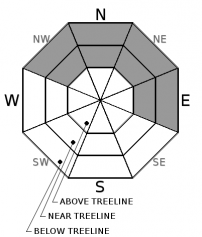
Two to three feet of new snow followed by sub freezing temperatures has fallen on a variety of old snow surfaces from firm, icy slopes, crusts, wind scoured sastrugi features and colder powder snow. Failure within the snowpack associated with this problem is possible at the old snow/new snow interface or anywhere within the new storm snow. Warming temperature have increased the upside down configuration (heavier snow on top of ligher snow) of the snowpack. This avalanche problem is most likely to be found below and near treeline in wind protected areas on shady, NW-N-NE-E aspects
Avalanche Problem 3: Persistent Slab
-
Character ?

-
Aspect/Elevation ?
-
Likelihood ?CertainVery LikelyLikelyPossible
Unlikely
-
Size ?HistoricVery LargeLargeSmall
On 12/23, a weak layer was buried by our last storm event, and now exists on cold, shady aspects (NW-N-NE-E) throughout the advisory area. This layer exists as rounding facets and is now buried by 2-4 feet of new snow. In many locations, this layer has been found to sit below a crust. No avalanches have occurred on this layer. Recent stability tests targeting this layer have been inconsistent, but have shown unstable results.
As new snow continues to increase the load on the snowpack, large persistent slab trending to deep slab avalanches are an increasing concern. Any avalanches that either initially fail on or step down to this weak layer will be large and destructive. Recent snowpit data has shown variability on the degree of weakness in this layer from one location to another, but it is still a problem. This problem is possible on NW-N-NE-E aspects near treeline and some areas below treeline.
Forecast Discussion
Conditions in the backcountry are a bit tricky at the moment. In west side locations, several natural avalanches and numerous signs of instability have been observed while on Mt Shasta, the snowpack seems more stable. We've got wind, storm and persistent slab avalanches on the table today. While the overall danger we think is decreasing, don't let the sunny skies lure you onto avalanche prone slopes. Winds have continued to blow, temperatures have remained below freezing and human triggered avalanches are possible today. Don't let your guard down. Dig a pit, conduct stability tests, look for signs of instability, ask questions.
=============================================================
LOCAL AREA ROAD, NORDIC, AND SNOWMOBILE PARK STATUS:
The Sand Flat cross country ski trails are in good shape and ready for your cross country skis and snow shoes. These are backcountry routes marked with blue diamonds on trees. Trails are not groomed. Snow shoers, please blaze a parallel trail to cross country skiers staying out of the skin track. These trails can be accessed via the Everett Memorial Highway. Thank you, and enjoy!
The Mt. Shasta Nordic Center is OPEN for the season! Take advantage of this wonderful venue. Groomed trails accomodate both classic and skate skiing styles. Rentals available. Visit their website for more details. http://www.mtshastanordic.org
The Pilgrim Creek & Deer Mountain Snowmobile Parks are open, however there is no snow at these locations currently. One must drive down the 19 road (Military Pass) for several miles to get to consistent snow before unloading. Private industry is logging out there so watch out for log trucks. Head to our "Education" tab on our website and find the snowmobile section for trail information, grooming status, and other sledder resources.
The Castle Lake Road is OPEN. The Everett Memorial Highway is OPEN. The Castle Lake and Everett Hwy are plowed year round to the trailheads. The roads are not always first priority, so your dawn patrol powder mission might be ceased if the plow has not made it up yet. Siskiyou County does a great job keeping the roads clear. Be respectful of the plow drivers if you encounter them. If you get to Bunny Flat before or during when the plow is there, please park on the uphill, LEFT side of the parking lot as you drive in. This is uphill and lookers right of the bathrooms. Thank You!
The Five Red Flags of Avalanche Danger any time of year include: 1) Recent/current avalanche activity 2) Whumphing sounds or shooting cracks 3) Recent/current heavy snowfall 4) Strong winds transporting snow 5) Rapid warming or rain on snow.
Recent Observations
Observations were made from both Mt Shasta and the west side (Castle Lake) of the forecast area yesterday. On Gray Butte, adjacent to Mt Shasta, any southerly slope had a variable thickness sun crust that had formed on the surface of the snowpack and will now be frozen this morning...this will present a breakable zipper crust for backcountry riders today. Above treeline, wind slabs were plentiful, soft to hard, small to large, 2-4 feet deep. A view of the mountain noted widespread wind affected snow. Our angle was poor, but what looked to be a natural avalanche was observed below Redbanks on the upper mountain. Snowpit tests continue to trend toward unstable results, however obvious signs of instability were absent during the tour yesterday. Several inches of settlement occured within the snowpack and trees were heavily rimed. Trail busting was arduous as 2-3 feet of new snow sits on the old snowpack. Numerous handpits on E-S-W aspects and one test pit dug on a NE aspect near treeline conveyed that the storm snow was showing better slab characteristics. Small column tests showed the majority of failures occurring on the 1/1 crust layer. Failures also occurred at, and directly below a crust present in many locations as the new/old interface. One ECT test propagated across the entire column. (See observation)
Over on the West side of the Interstate, observations noted several natural avalanches on northerly slopes and remarkably touchier conditions compared to Mt Shasta. Shooting cracks, whoomphing, recent avalanche and dicey looking cornices were reported. Crown depths ranged from 1-2 feet deep. It should be noted that conditions in the backcountry can vary greatly, even if "just across the street".
Wind transport was visible for most of the day on the upper mountain. Climbers should beware of firm and smooth slopes as well as pockets of wind loaded snow if attempting any of the routes on the mountain.
Weather and Current Conditions
Weather Summary
Clear and cold weather is going to cap the week off here in Mt Shasta. The sun will shine bright today, however temperatures have dropped about 15 degrees across the forecast area, compared to yesterday at this time. Winds will be calm at lower elevations. Only on the upper mountain will one encounter light to moderate east/northeast flow. Of most interest is this coming weekend... A deep trough sets up over the Eastern Pacific and will deliver extended precipitation or an "atmospheric river event"! Boy howdy, do we like the sound of that. The big bummer is that temperatures will warm considerably on Saturday shoving snow levels upwards of 6-8,000 feet. This will be short lived however and temperatures will fall again by the end of the weekend, just in time for a second round of heavy precipitation. Flooding is a concern due to rain on snow run off. We will certainly keep you posted on all this.
===========================================================
In Mt Shasta City at 0500, we have a current temperature of 18 F, sixteen degrees cooler than yesterday at this time.
On Mt Shasta (South Side) in the last 24 hours...
Old Ski Bowl - 7,600 feet, the current temperature is 6 degrees F. Temperatures have ranged from 4 F to 21 F. Snow on the ground totals 89 inches with no new snow and 2 inches of settlement.
Grey Butte - 8,000 feet, the current temperature is 9 degrees F. Temperatures have ranged from 8 F to 21 F. Winds have averaged 15-20 mph with gusts to 42 mph, blowing from the northwest until 1900 and then switching easterly, averaging 10 mph this morning.
Mt Eddy Range (West side of Interstate-5)...
Castle Lake - 5,600 feet, the current temperature is 9 degrees F. Temperatures have ranged from 9 F to 26 F. Snow on the ground totals 47 inches with no new snow and 3 inches of settlement.
Mt Eddy - 6,500 feet, the current temperature is 8 degrees F. Temperatures have ranged from 6 F to 24 F. Snow on the ground measures 51 inches with no new snow and 4 inches of settlement. Winds have averaged 2 mph with gusts to 12 mph, blowing southerly in direction.
THIS SEASON PRECIPITATION for MT SHASTA CITY: Since October 1st (the wet season), we have received 22.56 inches of water, normal is 16.15 inches, putting us at 139% of normal. For the month of January and for the year of 2017, we received 1.40 inches of water, normal is .94 inches, putting us at 148% of normal.
Always check the weather before you attempt to climb Mt Shasta. Further, monitor the weather as you climb. Becoming caught on the mountain in any type of weather can compromise life and limb. Be prepared.
| 0600 temperature: | 2 |
| Max. temperature in the last 24 hours: | 26 |
| Average wind direction during the last 24 hours: | Northwest then East |
| Average wind speed during the last 24 hours: | 10-20 mi/hr |
| Maximum wind gust in the last 24 hours: | 42 mi/hr |
| New snowfall in the last 24 hours: | 0 inches |
| Total snow depth: | 54 inches |
Two Day Mountain Weather Forecast
Produced in partnership with the Medford NWS
| For 7000 ft to 9000 ft | |||
|---|---|---|---|
|
Thursday (4 a.m. to 10 p.m.) |
Thursday Night (10 p.m. to 4 a.m.) |
Friday (4 a.m. to 10 p.m.) |
|
| Weather | Sunny | Clear | Sunny |
| Temperature (°F) | 19 | 10 | 23 |
| Wind (mi/hr) | East/Northeast 5-10 mph | East 0-5 mph | East, becoming south in the afternoon 5-10 mph |
| Precipitation SWE / Snowfall (in) | / 0 | / 0 | / 0 |
| For 9000 ft to 11000 ft | |||
| Thursday | Thursday Night | Friday | |
| Weather | Sunny, with a high near 15. Wind chill values as low as -18. Windy | Clear, with a low around 15. Wind chill values as low as -3. | Sunny, with a high near 19. |
| Temperature (°F) | 15 | 15 | 19 |
| Wind (mi/hr) | East/Northeast 10-15 mph, higher in the AM hours | East/Northeast 0 | South/Southwest 5-10 mph |
| Precipitation SWE / Snowfall (in) | / 0 | / 0 | / 0 |

