

You are here
Avalanche Advisory for 2017-01-10 07:13:32
- EXPIRED ON January 11, 2017 @ 7:13 amPublished on January 10, 2017 @ 7:13 am
- Issued by Andrew Kiefer - Mt Shasta Avalanche Center
Bottom Line
HIGH avalanche danger exists near treeline and above treeline on all aspects. CONSIDERABLE avalanche danger exists on all aspects below treeline. Today, the backcountry presents complex conditions, and a mix of avalanche problems. The potential for large and destructive avalanches exists. Travel in avalanche terrain is not recommended. Avalanche path run-out zones should be avoided. Natural avalanches are likely, and human-triggered avalanches are very likely.


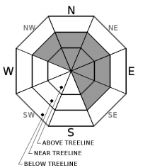
Avalanche Problem 1: Wind Slab
-
Character ?

-
Aspect/Elevation ?
-
Likelihood ?CertainVery LikelyLikelyPossible
 Unlikely
 -
Size ?HistoricVery LargeLargeSmall

Fresh wind slabs continue to form on NW-N-NE-E-SE aspects near and above treeline. West/southwest winds have been steady for the past 3 days and are actively transporting snow onto lee slopes and cross loading terrain features. The wind slabs throughout the advisory area are likely to be several feet thick, and could produce large and dangerous avalanches on slopes 35 degrees and steeper. Look for evidence of wind transported snow including drifts, plumes, cornice growth, and variable snow surface penetration. Avoid traveling in or below avalanche terrain with recent wind deposits.
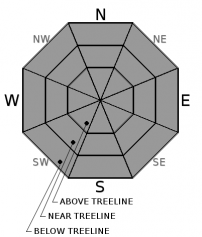
Avalanche Problem 2: Storm Slab
-
Character ?

-
Aspect/Elevation ?
-
Likelihood ?CertainVery LikelyLikelyPossible
Unlikely
-
Size ?HistoricVery LargeLargeSmall
With 4-10 inches of new snow in the past 24 hours, and an additional 16-20 inches expected today, storm slabs pose a significant concern. Storm slabs can be found on all aspects and at all elevations. They will become more likely to trigger as new snow accumulates throughout the day. Storm slabs can occur on slopes 30 degrees and steeper. Monitor snowfall accumulation and rate throughout the day, and assess how the new layers of snow are bonding to each other and to the old snow surface.
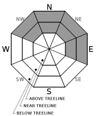
Avalanche Problem 3: Persistent Slab
-
Character ?

-
Aspect/Elevation ?
-
Likelihood ?CertainVery LikelyLikelyPossible
Unlikely
-
Size ?HistoricVery LargeLargeSmall
A weak layer of snow was buried on 12/23, and a persistent slab avalanche problem remains throughout the advisory area on NW-N-NE-E aspects near and below treeline.
There have been no reports of persistent slab avalanches occurring on the 12/23 layer. The distribution of this problem is isolated, and it primarily has been found on north facing, near treeline slopes. Evidence suggesting that the persistent slab avalanche problem exists is rare and hard to find. During the 01/08 rain on snow event, free water penetrated through the snowpack down to the 12/23 layer below treeline. This rain event, which has been followed by a significant cooling trend, may have erased the presence of the persistent slab avalanche problem at lower elevations. The persistent slab avalanche problem continues to pose a concern as the snowpack adjusts to new snow and added weight.
Forecast Discussion
Fluctuating freezing levels have created large variations in snow accumulation throughout the advisory area since Saturday. Areas below treeline have received a mix of rain and snow. Some near treeline areas have received 30 inches or more of snow. Few observations have been gathered in the field for terrain above treeline. However, above 8500ft, temperatures have remained cold, southwest winds have been strong, and continuous snowfall for the past 3 days has added several feet of new snow to upper elevation terrain.
A complex mix of avalanche problems exists today. New snow and strong winds are the primary factors driving rapid change. HIGH avalanche danger exists in the backcountry, and travel in or below avalanche terrain is not recommended.
Recent Observations
No avalanches, shooting cracks, or collapses have been observed or reported since Sunday. Over the past 24 hours, our remote weather stations report 4-10in of new snow, falling short of the 16-24in expected. Winds blew out of the west/southwest averaging 25-30 mph. Temperatures remained below freezing 6000ft and above.
Yesterday, significant evidence of wind transport was observed near treeline in the Green Butte Ridge area. The snowpack above 7800ft remained dry, and was not significantly affected by the 01/08 rain event. Wet/moist snow did fall up to this elevation though, and a supportable 6cm/2.5in melt-freeze crust now exists. Rain on snow occurred 7500ft and below, and at least the top 30cm/12in of the snowpack remains moist. The height of new snow since 01/06 measured at 8200ft was 50cm/20in by noon yesterday.
The Mount Shasta Ski Park received about 5in of new snow by 4pm yesterday. Wind loading and cornice formation was observed near the top of Coyote Butte. The 01/08 rain event has caused a stout 6cm crust to form at the snowpack surface.
Test pits dug near treeline and below treeline on southeasterly and northerly slopes revealed sudden and clean shears above the 01/08 rain crust, involving the snow from yesterday. By yesterday afternoon, not enough new snow had accumulated to form a slab on top of this layer in the observed locations. Several density breaks presented within the 50cm of recent storm snow, but none of these layers propagated in large column tests. The 12/23 layer is buried up to 1m/3ft deep. It produced sudden collapse results in small column tests. Results in large column tests were very inconsistent, but overall, trended toward unlikely propogation on the 12/23 layer despite the recent load of new snow.
Weather and Current Conditions
Weather Summary
An atmospheric river event pushes into the advisory area today. The National Weather Service Winter Storm Warning remains in effect for areas 3000ft and above until 4pm. Freezing levels will be near 4500ft today and tonight, and will drop to the 1000ft level by tomorrow. The 6000ft level is expecting snow accumulation of 16-20 inches, and just over 1.5 inches of snow water equivalent by 10pm tonight. Temperatures for this elevation will reach highs in the mid 30’s. Southerly winds will average 20-30 mph with gusts up to 60 mph.
Tonight, a mix of snow and rain may occur up to 6000ft, with snow showers expected after midnight at all elevations. An additional 5-11 inches of overnight snow accumulation is possible. Winds will be southerly. Unsettled weather will continue through Thursday.
===========================================================
In Mt Shasta City at 0500, we have a current temperature of 36 F with cloudy skies and light rain.
On Mt Shasta (South Side) in the last 24 hours...
Old Ski Bowl - 7,600 feet, the current temperature is 22 degrees F. Temperatures have ranged from 16 F to 22 F. Snow on the ground totals 111 inches with 10 inches of new snow.
Grey Butte - 8,000 feet, the current temperature is 21 degrees F. Temperatures have ranged from 16 F to 22 F. Winds have averaged 25-30 mph with gusts to 49 mph, blowing out of the west/southwest.
Mt Eddy Range (West side of Interstate-5)...
Castle Lake - 5,600 feet, the current temperature is 27 degrees F. Temperatures have ranged from 22 F to 27 F. Snow on the ground totals 50 inches with 3 inches of new snow.
Mt Eddy - 6,500 feet, the current temperature is 26 degrees F. Temperatures have ranged from 20 F to 26 F. Snow on the ground measures 57 inches with 7 inches of new snow. Winds have averaged 1-3 mph with gusts to 16 mph, blowing out of the southwest and shifting to the southeast.
THIS SEASON PRECIPITATION for MT SHASTA CITY: Since October 1st (the wet season), we have received 26.96 inches of water, normal is 17.35 inches, putting us at 155% of normal. For the month of January and for the year of 2017, we received 5.80 inches of water, normal is 2.14 inches, putting us at 270% of normal.
Always check the weather before you attempt to climb Mt Shasta. Further, monitor the weather as you climb. Becoming caught on the mountain in any type of weather can compromise life and limb. Be prepared.
| 0600 temperature: | 26 |
| Max. temperature in the last 24 hours: | 26 |
| Average wind direction during the last 24 hours: | West/southwest |
| Average wind speed during the last 24 hours: | 10-15 mi/hr |
| Maximum wind gust in the last 24 hours: | 30 mi/hr |
| New snowfall in the last 24 hours: | 4 inches |
| Total snow depth: | 60 inches |
Two Day Mountain Weather Forecast
Produced in partnership with the Medford NWS
| For 7000 ft to 9000 ft | |||
|---|---|---|---|
|
Tuesday (4 a.m. to 10 p.m.) |
Tuesday Night (10 p.m. to 4 a.m.) |
Wednesday (4 a.m. to 10 p.m.) |
|
| Weather | Heavy Snow and Windy. Chance of precipitation 100% | Heavy Snow and Windy. Chance of precipitation 100%. | Snow Showers Likely. Chance of precipitation 70% |
| Temperature (°F) | 33 | 23 | 27 |
| Wind (mi/hr) | South 25-30 mph | South/southwest 20-30 mph | Southwest 15-20 mph |
| Precipitation SWE / Snowfall (in) | / 24-30 | / 11-17 | / 3-5 |
| For 9000 ft to 11000 ft | |||
| Tuesday | Tuesday Night | Wednesday | |
| Weather | Heavy Snow and Windy. | Heavy Snow and Windy. | Snow Showers and Windy. Chance of Precipitation 90%. |
| Temperature (°F) | 22 | 9 | 9 |
| Wind (mi/hr) | South/southwest 50-60 mph, Gusting 70+ mph | West/southwest 29-35 | West/southwest 35-40 mph |
| Precipitation SWE / Snowfall (in) | / 29-35 | / 11-17 | / 3-5 |

