

You are here
Avalanche Advisory for 2017-01-24 07:07:09
- EXPIRED ON January 25, 2017 @ 7:07 amPublished on January 24, 2017 @ 7:07 am
- Issued by Andrew Kiefer - Mt Shasta Avalanche Center
Bottom Line
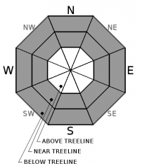
CONSIDERABLE avalanche danger exists near treeline and above treeline. The avalanche danger is MODERATE below treeline. Dangerous conditions exist in the backcountry. Wind slab avalanches have the potential to be large and destructive. Storm slab and cornice fall avalanches remain concerns. Natural avalanches are possible, and human triggered avalanches are likely today.


Avalanche Problem 1: Wind Slab
-
Character ?

-
Aspect/Elevation ?

-
Likelihood ?CertainVery LikelyLikelyPossible
 Unlikely
 -
Size ?HistoricVery LargeLargeSmall

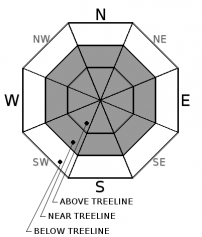
Wind slabs are the primary avalanche problem, and may exist on all aspects near and above treeline. In wind-loaded terrain 35 degrees and steeper, human triggered wind slab avalanches are likely. The timing for natural wind slab avalanches to occur may have peaked during our recent storms, but natural wind slab avalanches remain possible today. A wind slab avalanche would be large and destructive in these conditions. Watch for blowing snow, cornice formation, drifts of loaded snow and textured snow surfaces to identify areas where the wind slab problem may exist. Avoid traveling on or below wind-loaded terrain 35 degrees and steeper.
Avalanche Problem 2: Storm Slab
-
Character ?

-
Aspect/Elevation ?
-
Likelihood ?CertainVery LikelyLikelyPossible
Unlikely
-
Size ?HistoricVery LargeLargeSmall
Several feet of new snow have been added to the snowpack over the past week, and the potential for storm slab avalanches exists on all aspects near and below treeline. Storm slabs could involve the majority of the new snow, and human triggered storm slab avalanches are possible today. Cracking, collapsing, whumphing, and recent avalanches are all obvious clues of unstable snow and indications of a reactive storm slab problem. Avoid slopes 30 degrees and steeper where these signs exist.
Avalanche Problem 3: Cornice
-
Character ?

-
Aspect/Elevation ?
-
Likelihood ?CertainVery LikelyLikelyPossible
Unlikely
-
Size ?HistoricVery LargeLargeSmall
Small to large cornice features exist on many ridgelines throughout the advisory area. Recent snow accumulation and wind transport are adding weight to existing cornices, and building new cornice features. Cornices are often overhung and can break in very unpredictable ways. If cornices fail, they pose a significant risk of triggering slopes below. Be sure to stand back on ridgelines, and avoid traveling on or below avalanche terrain threatened by cornice hazard.
Forecast Discussion
Dangerous avalanche conditions remain throughout the advisory area. The snowpack needs time to adjust to the added weight from the several feet of new snow we have recently received. The current conditions require careful snowpack evaluation and cautious route finding. Clearing skies, sunshine, and deep powder snow can easily comprise our abilities to make good decisions in the backcountry. Prioritize objective hazard evaluation today, and don’t let your desires and emotions get the best of you.
Recent Observations
The storm series beginning on January 17th has finally come to a close, and our 7-day storm total for the advisory area ranges from 6-8 feet of new snow above 6000ft.
Yesterday, a recent natural avalanche was observed near treeline. The avalanche ran during our storm events, likely 2 days ago, on a northwest aspect at 8000ft on Grey Butte. The crown of the avalanche ranged from 3-4ft, and the bed surface had filled in with at least 2 additional feet of new snow since the event. The crown was 150ft wide and the avalanche ran 600ft to the bottom of the slope. The avalanche failed within new snow. (See photos in Observations below)
The sky was obscured for most of the day above 6000ft, and visibility near treeline and above treeline was poor. Winds were light, and a trace of new snow accumulated.
A test pit was dug yesterday on a south facing aspect at 7800ft on a nearby slope to the avalanche (See photo in Observations below). The height of new snow since 01/17 was 155cm, and the total height of the snowpack was 335cm. The recent snow bonded well to the old snow surface, and the lower snowpack was strong and well consolidated. The new snow presented a right side up configuration. Stability tests resulted in inconsistent failures on density breaks within the top 155cm of new snow. No propagation occurred in large column tests. Overall, the snowpack structure was good, and the new snow bonded well to itself in this test pit location.
Weather and Current Conditions
Weather Summary
An upper level trough of low pressure has pulled away from the region and now begins to move south. A very slight chance of snow showers remains for early this morning, and skies will become mostly sunny today. High temperatures for 6000ft will be in the low to mid 30’s, and light northwest winds will blow. Mostly calm and quiet weather will be in store for tonight, but temperature inversions are expected, and valley fog is possible. Tomorrow morning a weak frontal system brings another chance for light snow showers, but will quickly dissipate. A strong ridge of high pressure will develop afterwards, and will remain in place through the weekend and into next week.
===========================================================
In Mt Shasta City at 0500, we have a current temperature of 19 F.
On Mt Shasta (South Side) in the last 24 hours...
Old Ski Bowl - (7,600ft) Not recording data at this time. We are working to get this station up and running again ASAP. Sand Flat (6,750 feet) the current temperature is 9 degrees F. Temperatures have ranged from 9 F to 30 F. Snow on the ground totals 106 inches with a trace of new snow and 7 inches of settlement.
Grey Butte - 8,000 feet, the current temperature is 11 degrees F. Temperatures have ranged from 10 F to 25 F. Winds have averaged 5-15 mph with gusts to 28 mph, variable in direction blowing west/northwest and shifting south/southeast.
Mt Eddy Range (West side of Interstate-5)...
Castle Lake - 5,600 feet, the current temperature is 18 degrees F. Temperatures have ranged from 15 F to 29 F. Snow on the ground totals 107 inches with 2 inches of new snow and 3 inches of settlement.
Mt Eddy - 6,500 feet, the current temperature is 18 degrees F. Temperatures have ranged from 12 F to 23 F. Snow on the ground measures 91 inches with a trace of new snow and 3 inches of settlement. Winds have averaged 1-3 mph with gusts to 8 mph, blowing south/southeast and shifting south/southwest.
THIS SEASON PRECIPITATION for MT SHASTA CITY: Since October 1st (the wet season), we have received 33.52 inches of water, normal is 20.57 inches, putting us at 163% of normal. For the month of January and for the year of 2017, we received 12.36 inches of water, normal is 5.36 inches, putting us at 230% of normal.
Always check the weather before you attempt to climb Mt Shasta. Further, monitor the weather as you climb. Becoming caught on the mountain in any type of weather can compromise life and limb. Be prepared.
| 0600 temperature: | 9 |
| Max. temperature in the last 24 hours: | 30 |
| Average wind direction during the last 24 hours: | South/Southeast |
| Average wind speed during the last 24 hours: | 5-10 mi/hr |
| Maximum wind gust in the last 24 hours: | 25 mi/hr |
| New snowfall in the last 24 hours: | .5 inches |
| Total snow depth: | 106 inches |
Two Day Mountain Weather Forecast
Produced in partnership with the Medford NWS
| For 7000 ft to 9000 ft | |||
|---|---|---|---|
|
Tuesday (4 a.m. to 10 p.m.) |
Tuesday Night (10 p.m. to 4 a.m.) |
Wednesday (4 a.m. to 10 p.m.) |
|
| Weather | Mostly Sunny | Partly Cloudy | Partly Sunny. 20% Chance of Snow Showers After 10am. |
| Temperature (°F) | 29 | 18 | 26 |
| Wind (mi/hr) | North/Northwest 7-9 mph | North 10 | North 10 mph |
| Precipitation SWE / Snowfall (in) | / 0 | / 0 | / 0 |
| For 9000 ft to 11000 ft | |||
| Tuesday | Tuesday Night | Wednesday | |
| Weather | Cold and Blustery. Wind Chill Values as Low as -17F. | Partly Cloudy and Windy. | Chance of Snow Showers and Windy. Chance of Precipitation 30%. |
| Temperature (°F) | 10 | 9 | 13 |
| Wind (mi/hr) | North 20-30 mph | North/Northwest 0 | Northwest 30-40 mph |
| Precipitation SWE / Snowfall (in) | / 0 | / 0 | / 0 |

