

You are here
Avalanche Advisory for 2017-01-26 06:20:24
- EXPIRED ON January 27, 2017 @ 6:20 amPublished on January 26, 2017 @ 6:20 am
- Issued by Nick Meyers - Shasta-Trinity National Forest
Bottom Line
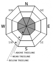
One will find LOW avalanche danger in below and near treeline areas today. Above treeline, MODERATE danger remains for existing wind slabs. Above treeline and on the upper mountain, unsupported slopes steeper than 37 degrees will present the best chance of hosting small to large wind slabs. Wind slabs will be stubborn to trigger, however consequences could be devastating. Climbers should beware if choosing to make a winter ascent of Shasta during our current spell of good weather.


Avalanche Problem 1: Wind Slab
-
Character ?

-
Aspect/Elevation ?
-
Likelihood ?CertainVery LikelyLikelyPossible
 Unlikely
 -
Size ?HistoricVery LargeLargeSmall

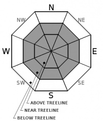
The existing wind slab problem will be limited to above treeline terrain on unspported, steep slopes, near rocks outcrops, narrow gullies/couloirs and along ridgelines. Slopes steeper than 37 degrees should be most suspect. This is a low likelihood, high consequence situation. Wind slabs would be large if triggered, however triggering said slabs is going to be difficult today.
Moderate north/northwest/northeast winds today could create new wind slabs on southerly aspects. These new wind slabs will be confined to upper elevation terrain and will be small in size but certainly could be enough to bury you or take you for a ride.
Avalanche Problem 2: Cornice
-
Character ?

-
Aspect/Elevation ?
-
Likelihood ?CertainVery LikelyLikelyPossible
Unlikely
-
Size ?HistoricVery LargeLargeSmall
This avalanche problem is mostly confined, but not limited to, the west side of the forecast area. Places like Castle Lake, Cliff Lake and other ridgelines on the west side of Interstate 5 will host small to large cornices on various aspects. Cornices are gaining strength daily. Regardless, it's always best to stay back. Cornices that fail can often trigger avalanches on slopes below. Identify terra firma. Rocks, trees or shrubs that poke through a wind scoured ridgeline are excellent indicators. If snow prevails, simply stay back! Diving boards are best made of fiberglass, not snow!
Forecast Discussion
Currently, our snowpack depth and strata are looking pretty darn good. We have a isothermic, right side up layering within the snowpack and no recent signs of avalanche instability. Soft powder snow prevails but this will dwindle with the sunny days and warming temperatures ahead. The road (Everitt Memorial Hwy) to Bunny Flat (south side trailhead on Mt Shasta) and Castle Lake (west side trailhead) remain unplowed and closed at this time. Access to the backcountry can be made via the Mt Shasta Ski Park to Gray Butte or by parking at McBride Springs. Snowmobile access will get you to many areas. The Pilgrim Creek snowmobile park is open and trails are being groomed daily. Overall, good stability will be found within the forecast area. The wind slab problem is confined to above treeline terrain and remains the high consequence, low likelihood avalanche problem. While we may see a lull in avalanche activity, a solid wind event could continue to load leeward slopes. Keep this in mind always. Even though it's not snowing out, wind can still load slopes 10x faster than snow falling from the sky. A lot of light density snow remains available for transport currently.
Climbing the mountain this weekend? Several days of good weather may lure a few contestants onto the mountain. A winter ascent of Mt Shasta significantly up's the ante. Be prepared, carry a beacon, shovel and probe and know how to use them! Be able to identify avalanche terrain and features of concern. Deep powder snow prevails and skis, splitboard or snowshoes are essential. Post-holing is guaranteed for those that come without. Lastly, access to the south side routes is limited to McBride Springs, approximately 4 miles up the Everitt Memorial Hwy. This means about 6 miles of snow covered roads OR an alternate route up Cascade Gulch toward Horse Camp. Please call the Mt Shasta Ranger Station for further details. 530-926-4511
Recent Observations
Observations yesterday were made up the length of the Everitt Memorial Highway from McBride Springs up into the Old Ski Bowl. A side note, the OSB weather station is back up and running! Thanks for your patience on this. A successful repair was executed yesterday and snow depth at the site rang in at 164 inches... that is 13.6 feet of snow. Mind you that the snow depth sensor is about 20 feet off the ground. We still have a fair bit of winter remaining. I wouldn't be surprised if this station becomes buried this season! Overall, snow surfaces consist of mostly soft powder snow with gradually more dense snow as one digs downward. Below 6,000 feet and some isolated, sunny aspects above 6,000 feet, a 1cm sun crust exists sporadically across the terrain. Slope angle and facing direction were a big player in the distribution of this zipper crust. Above 6,000, primarily powder remains and a trace of new snow was added yesterday as light snow flurries peppered the mountains for a portion of the day. Winds were very calm. The same old avalanches on Gray Butte and Green Butte from several days ago were noted but no recent signs of instability were observed. Visibility was difficult above 9,000 feet.
Weather and Current Conditions
Weather Summary
Not much change going on in the weather department for the remainder of the week or weekend for that matter. Valley fog and air stagnation will remain but should clear by afternoon hours. An upper level ridge builds in the Pacific Northwest today. We will see cloudy to partly cloudy skies this morning that should begin to clear up later on and tomorrow will be sunny. Any lingering precip today will likely remain to the higher mountains and fall in the hundreths of an inch catagory. Winds appear to be light at lower and even upper elevations. Models still suggest the door opening to the Pacific next week and a wet pattern to ensue around Wednesday.
===========================================================
In Mt Shasta City at 0500, we have a current temperature of 26 F, one degree warmer than yesterday at this time.
On Mt Shasta (South Side) in the last 24 hours...
Old Ski Bowl - 7,600ft. the current temperature is 14 degrees F. Temperatures have ranged from 13 F to 23 F. Snow on the ground measures 164 inches with no new snow and little settlement.
Grey Butte - 8,000 feet, the current temperature is 13 degrees F. Temperatures have ranged from 14 F to 21 F. Winds have averaged 5-10 mph with gusts to 28 mph, variable in direction.
Mt Eddy Range (West side of Interstate-5)...
Castle Lake - 5,600 feet, the current temperature is 19 degrees F. Temperatures have ranged from 19 F to 30 F. Snow on the ground totals 100 inches with no new snow and 3 inches of settlement.
Mt Eddy - 6,500 feet, the current temperature is 20 degrees F. Temperatures have ranged from 14 F to 24 F. Snow on the ground measures 86 inches with no new snow and 1 inch of settlement. Winds have averaged 1-2 mph with gusts to 4 mph, blowing southeast to southwest.
THIS SEASON PRECIPITATION for MT SHASTA CITY: Since October 1st (the wet season), we have received 32.26 inches of water, normal is 21.0 inches, putting us at 153% of normal. For the month of January and for the year of 2017, we received 11.10 inches of water, normal is 5.79 inches, putting us at 191% of normal.
Always check the weather before you attempt to climb Mt Shasta. Further, monitor the weather as you climb. Becoming caught on the mountain in any type of weather can compromise life and limb. Be prepared.
| 0600 temperature: | 18 |
| Max. temperature in the last 24 hours: | 24 |
| Average wind direction during the last 24 hours: | Variable |
| Average wind speed during the last 24 hours: | 0-5 mi/hr |
| Maximum wind gust in the last 24 hours: | 5-10 mi/hr |
| New snowfall in the last 24 hours: | .25-.5 inches |
| Total snow depth: | 101 inches |
Two Day Mountain Weather Forecast
Produced in partnership with the Medford NWS
| For 7000 ft to 9000 ft | |||
|---|---|---|---|
|
Thursday (4 a.m. to 10 p.m.) |
Thursday Night (10 p.m. to 4 a.m.) |
Friday (4 a.m. to 10 p.m.) |
|
| Weather | Isolated snow showers before 10am. Cloudy through mid morning, then gradual clearing. Chance of precipitation is 20%. | Mostly clear | Sunny |
| Temperature (°F) | 31 | 22 | 39 |
| Wind (mi/hr) | North 0-5 mph | East/Northeast 0-5 mph | East/Northeast 0-5 mph |
| Precipitation SWE / Snowfall (in) | / trace | / 0 | / 0 |
| For 9000 ft to 11000 ft | |||
| Thursday | Thursday Night | Friday | |
| Weather | Isolated snow showers before 10am. Cloudy through mid morning, then gradual clearing. Wind chill values as low as -10. Chance of precipitation is 20%. | Mostly clear. Wind chill values as low as -1. Blustery. | Sunny. |
| Temperature (°F) | 19 | 19 | 27 |
| Wind (mi/hr) | North 10-15 mph, increasing in the afternoon to 20 mph. | North/Northwest trace | Northwest 10-15 mph |
| Precipitation SWE / Snowfall (in) | / trace | / 0 | / 0 |

