

You are here
Avalanche Advisory for 2017-01-28 06:27:22
- EXPIRED ON January 29, 2017 @ 6:27 amPublished on January 28, 2017 @ 6:27 am
- Issued by Andrew Kiefer - Mt Shasta Avalanche Center
Bottom Line
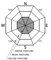
MODERATE avalanche danger continues above treeline, primarily in terrain above 12,000ft and on wind loaded slopes steeper than 35 degrees. LOW avalanche danger exists for all aspects near treeline and below treeline. Snow is available for transport, and fresh wind slabs may build today. With sunny skies and warm temperatures expected, be on the lookout for falling rime ice as well as possible wet loose snow surface instabilities.


Avalanche Problem 1: Wind Slab
-
Character ?

-
Aspect/Elevation ?
-
Likelihood ?CertainVery LikelyLikelyPossible
 Unlikely
 -
Size ?HistoricVery LargeLargeSmall

With blowing snow visible above 12,000ft on Mt Shasta for the past 2 days, it is possible that new wind slabs could have formed in isolated areas. Redbanks, the Trinity Chutes, the east side gullies off of Sargents Ridge/Thumb Rock, and the Hotlum Headwall/Hotlum-Wintun are examples of areas where fresh deposits of wind loaded snow are most likely to exist. These locations are where steep slopes (>37 degrees) roll off the lower angle slopes of the upper mountain. These new, small to medium size wind slabs will be a concern for climbers and ski mountaineers who venture into upper elevation terrain. While these wind slabs may not produce large avalanches, a slide in any terrain where they do exist would likely have high consequences.
Forecast Discussion
The road (Everitt Memorial Hwy) to Bunny Flat (south side trailhead on Mt Shasta) and Castle Lake (west side trailhead) remain unplowed and closed at this time. Access to the backcountry can be made via the Mt Shasta Ski Park to the Gray Butte area or by parking at McBride Springs and heading up the road or Cascade Gulch. Snowmobile access will get you to many areas. The Pilgrim Creek and Deer Mountain snowmobile parks are open and trails are being groomed daily.
Soft snow conditions may lure backcountry travelers into complex avalanche terrain in upper elevations. Make sure to prioritize snow stability assessment today. Use visual observations to identify areas of loaded snow, and avoid slopes steeper than 35 degrees where evidence of the wind slab problem exists. With warm temperatures overnight and today, also be on the lookout for wet loose instabilities. If you are heading into the backcountry, always carry a beacon, shovel, and probe and know how to use them! As mentioned, access to the south side routes is limited to McBride Springs, approximately 4 miles up the Everitt Memorial Hwy. This means about 6 miles of snow covered roads OR an alternate route up Cascade Gulch toward Horse Camp. Please call the Mt Shasta Ranger Station for further details. 530-926-4511
Recent Observations
A strong temperature inversion is currently in place with the majority of the advisory area experiencing just a light freeze overnight, and warm temperatures this morning in the mid to upper 30’s at the majority of our remote weather stations.
The most recent avalanche activity occurred within our last storm ending on January 23rd. Snowpack observations continue to reveal a deep, right side up, and strong snowpack. For several days in a row, stability tests have not identified any significant layers of concern, and they illustrate a low likelihood for layers within the snowpack to fracture under stress.
Snowpack surfaces are variable, but a significant amount of unconsolidated, light snow exists. This allows for great skiing and riding in many places, but it also means plenty of snow is available for wind transport. Lately, winds have been light and variable near and below treeline. Lingering areas of loaded snow that formed during our most recent storm have been observed above treeline. Yesterday, winds were observed blowing snow at the 12,000ft level and above on Mt. Shasta.
Weather and Current Conditions
Weather Summary
A surge of high-level clouds may move through the area this morning, followed by mostly clear and sunny skies throughout the day. A temperature inversion will be in place with mountain highs in the mid 40’s to lower 50’s. Winds will continue to be light and variable. Temperatures will cool to just below freezing overnight. Sunday will bring more sunny weather in the morning with a chance of partly cloudy skies in the afternoon. A warming trend will continue for now, and wind speeds will ramp up by tomorrow afternoon.
===========================================================
In Mt Shasta City at 0500, we have a current temperature of 23 F with clear skies.
On Mt Shasta (South Side) in the last 24 hours...
Old Ski Bowl - 7,600ft. the current temperature is 35 degrees F. Temperatures have ranged from 23 F to 48 F. Snow on the ground measures 148 inches with no new snow and little settlement.
Grey Butte - 8,000 feet, the current temperature is 36 degrees F. Temperatures have ranged from 24 F to 42 F. Winds have averaged 5-10 mph with gusts to 14 mph, primarily out of east/northeast.
Mt Eddy Range (West side of Interstate-5)...
Castle Lake - 5,600 feet, the current temperature is 36 degrees F. Temperatures have ranged from 21 F to 36 F. Snow on the ground totals 97 inches with no new snow and 1 inch of settlement.
Mt Eddy - 6,500 feet, the current temperature is 32 degrees F. Temperatures have ranged from 18 F to 42 F. Snow on the ground measures 82 inches with no new snow and 2 inches of settlement. Winds have averaged 1-5 mph with gusts to 6 mph, blowing west/southwest.
THIS SEASON PRECIPITATION for MT SHASTA CITY: Since October 1st (the wet season), we have received 32.26 inches of water, normal is 21.43 inches, putting us at 151% of normal. For the month of January and for the year of 2017, we received 11.10 inches of water, normal is 6.22 inches, putting us at 178% of normal.
Always check the weather before you attempt to climb Mt Shasta. Further, monitor the weather as you climb. Becoming caught on the mountain in any type of weather can compromise life and limb. Be prepared.
| 0600 temperature: | 23 |
| Max. temperature in the last 24 hours: | 34 |
| Average wind direction during the last 24 hours: | Northeast |
| Average wind speed during the last 24 hours: | 0-5 mi/hr |
| Maximum wind gust in the last 24 hours: | 10 mi/hr |
| New snowfall in the last 24 hours: | 0 inches |
| Total snow depth: | 96 inches |
Two Day Mountain Weather Forecast
Produced in partnership with the Medford NWS
| For 7000 ft to 9000 ft | |||
|---|---|---|---|
|
Saturday (4 a.m. to 10 p.m.) |
Saturday Night (10 p.m. to 4 a.m.) |
Sunday (4 a.m. to 10 p.m.) |
|
| Weather | Sunny | Mostly clear | Sunny |
| Temperature (°F) | 43 | 29 | 48 |
| Wind (mi/hr) | East 0-5 mph | East/Southeast 0-5 mph | East/Southeast 6-8 mph |
| Precipitation SWE / Snowfall (in) | / 0 | / 0 | / 0 |
| For 9000 ft to 11000 ft | |||
| Saturday | Saturday Night | Sunday | |
| Weather | Sunny | Mostly clear | Mostly Sunny and Breezy |
| Temperature (°F) | 32 | 32 | 33 |
| Wind (mi/hr) | West 10-15 mph | Northeast, becoming Southwest after midnight 0 | West 20-30 mph |
| Precipitation SWE / Snowfall (in) | / 0 | / 0 | / 0 |

