

You are here
Avalanche Advisory for 2017-02-01 06:59:46
- EXPIRED ON February 2, 2017 @ 6:59 amPublished on February 1, 2017 @ 6:59 am
- Issued by Nick Meyers - Shasta-Trinity National Forest
Bottom Line
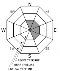
MODERATE avalanche danger exists above treeline on N, NE, E, and SE aspects. Wind loaded slopes steeper than 35 degrees in alpine terrain are the areas where the wind slab problem poses a concern for backcountry travelers. Small to medium size human-triggered avalanches are possible in these specific areas today. LOW avalanche danger exists for all aspects near and below treeline.
A winter weather advisory is in effect from 10pm this evening to 4pm PST Thursday.


Avalanche Problem 1: Wind Slab
-
Character ?

-
Aspect/Elevation ?
-
Likelihood ?CertainVery LikelyLikelyPossible
 Unlikely
 -
Size ?HistoricVery LargeLargeSmall

Steady west/northwest winds (20-30 mph with gusts 40-50+ mph) over the past 48 hours has created new small to medium size wind slabs above treeline within the forecast area. New wind slabs have the potential to exist above treeline on N, NE, E, and SE aspects. Slopes steeper than 35 degrees above treeline will be the most likely areas for a person to trigger a wind slab. Snow is available for transport and southwest winds will continue today. Use visual observations to identify areas of loaded snow, and avoid slopes steeper than 35 degrees where evidence of the wind slab problem exists.
Forecast Discussion
Today will be the last day of low to moderate avalanche danger. A winter storm will bring ample amounts of rain, snow and wind to the forecast area. This will increase the avalanche danger on many aspects and elevations. Wind slabs, storm slabs, cornices and potentially some loose-wet related (rain on snow) avalanche problems will present themselves over the next several days. We have no existing weak layers of concern in our current snowpack. Instabilities will likely lie within new snow layers and/or the old snow/new snow interface. Access to Bunny Flat and Castle Lake are still limited to McBride Springs and the gate along the Castle Lake road.
Recent Observations
Overall, snowpack stability is very good throughout the advisory area. It has been over a week since any significant avalanche activity has occurred. Observations were made yesterday on a tour from McBride Springs, ascending up Cascade Gulch and finishing at Horse Camp (treeline). Overall, snow conditions were variable. Below treeline, snow surface was moist with a slight crust on sun affected aspects. There was a noticable change at around 6,800ft, where the snow surfaces on shaded slopes became colder and drier. At an elevation of 7,680ft, the snow pack was just over 3 meters deep. The recent storm snow is continuing to consolidate with 1-2 inches of settlement reported from snow depth sensors. The storm snow/old snow interface was 130cm below the surface and is well bonded. We dug a test pit and observed the upper and mid snowpack to be right side up with no layers of concern for the up and coming storm. This snowpack structure is representative of reports and information gathered from many other locations within the forecast area. All stability tests indicate a strong and stable snowpack. West/northwest winds were observed blowing snow over Casaval Ridge and loading east aspects. The sky was overcast throughout the day.
Weather and Current Conditions
Weather Summary
The NWS has issued a winter weather advisory in effect from 10pm this evening to 4pm PST Thursday.... further, a winter storm watch is in effect from Thursday afternoon through Friday evening above 5,000 feet. Our week long hiatus from winter weather will come to a close this evening. Expect increasing clouds today and the beginning of a period of wet and windy weather to hit the start gate tonight. The remainder of the week and this weekend will bring upwards of 4 to 4.5 inches of water to the area though Sunday morning. Snow levels will start near 3,500 to 4,000 feet tomorrow and could flucturate +/- 1,000 feet over the next several days. Hang on to your hats as winds will be cranking a steady 30-40 mph with gusts likely 50+ mph above treeline. Day time highs will be in the low 40's today and dropping into the mid 30's tomorrow, below treeline. Near and above treeline, day time highs will be in the mid 20's and dropping to low 20's tonight and tomorrow. Snow fall of 3-5" tonight and 5-8" tomorrow is expected for Bunny Flat and above.
===========================================================
In Mt Shasta City at 0500, we have a current temperature of 31 F.
On Mt Shasta (South Side) in the last 24 hours...
Old Ski Bowl - 7,600ft. the current temperature is 33 degrees F. Temperatures have ranged from 32 F to 41 F. Snow on the ground measures 141 inches with no new snow and 2 inches of settlement.
Grey Butte - 8,000 feet, the current temperature is 30 degrees F. Temperatures have ranged from 29 F to 37 F. Winds have averaged 25 mph with gusts to 42 mph, blowing out of the west/northwest.
Mt Eddy Range (West side of Interstate-5)...
Castle Lake - 5,600 feet, the current temperature is 35 degrees F. Temperatures have ranged from 34 F to 51 F. Snow on the ground totals 90 inches with no new snow and 1 inch of settlement.
Mt Eddy - 6,500 feet, the current temperature is 35 degrees F. Temperatures have ranged from 31 F to 45 F. Snow on the ground measures 75 inches with no new snow and 2 inches of settlement. Winds have averaged 1-2 mph with gusts to 9 mph, blowing out of the southerly in nature.
THIS SEASON PRECIPITATION for MT SHASTA CITY: Since October 1st (the wet season), we have received 32.26 inches of water, normal is 22.27 inches, putting us at 144% of normal. For the month of January and for the year of 2017, we received 11.10 inches of water, normal is 7.06 inches, putting us at 157% of normal.
Always check the weather before you attempt to climb Mt Shasta. Further, monitor the weather as you climb. Becoming caught on the mountain in any type of weather can compromise life and limb. Be prepared.
| 0600 temperature: | 30 |
| Max. temperature in the last 24 hours: | 42 |
| Average wind direction during the last 24 hours: | west/northwest |
| Average wind speed during the last 24 hours: | 5-10 mi/hr |
| Maximum wind gust in the last 24 hours: | 15 mi/hr |
| New snowfall in the last 24 hours: | 0 inches |
| Total snow depth: | 89 inches |
Two Day Mountain Weather Forecast
Produced in partnership with the Medford NWS
| For 7000 ft to 9000 ft | |||
|---|---|---|---|
|
Wednesday (4 a.m. to 10 p.m.) |
Wednesday Night (10 p.m. to 4 a.m.) |
Thursday (4 a.m. to 10 p.m.) |
|
| Weather | A 30 percent chance of snow after 4pm. Mostly cloudy. Little or no snow accumulation expected. | Snow, mainly after 10pm. Breezy. Chance of precipitation is 90%. | Snow. Breezy. Chance of precipitation is 100%. |
| Temperature (°F) | 43 | 26 | 36 |
| Wind (mi/hr) | South 10-15 mph | South 15-20 mph | South 15-20 mph |
| Precipitation SWE / Snowfall (in) | / 0 | / 2-4 | / 5-8 |
| For 9000 ft to 11000 ft | |||
| Wednesday | Wednesday Night | Thursday | |
| Weather | A 30 percent chance of snow after 4pm. Mostly cloudy. Windy. Little or no snow accumulation expected. | Snow, mainly after 10pm. Wind chill values as low as -3. Windy. Chance of precipitation is 90%. | Snow. Wind chill values as low as -5. Windy. Chance of precipitation is 100%. |
| Temperature (°F) | 25 | 20 | 21 |
| Wind (mi/hr) | Southwest 30-35 mph | South 0 | Southwest 35-40 mph, increasing in the AM |
| Precipitation SWE / Snowfall (in) | / 0 | / 3-5 | / 5-10 |

