

You are here
Avalanche Advisory for 2017-02-09 06:51:01
- EXPIRED ON February 10, 2017 @ 6:51 amPublished on February 9, 2017 @ 6:51 am
- Issued by Nick Meyers - Shasta-Trinity National Forest
Bottom Line
The wet loose avalanche problem will remain a concern today in below and near treeline terrain steeper than 35 degrees. Above treeline, the wind slab avalanche problem remains as high intensity snowfall and gale force southerly winds have been and will continue to rapidly load primarily the top half of the compass. Expect HIGH avalanche danger for wind slabs above treeline and MODERATE danger below and near treeline for loose wet avalanches.


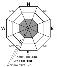
Avalanche Problem 1: Wind Slab
-
Character ?

-
Aspect/Elevation ?
-
Likelihood ?CertainVery LikelyLikelyPossible
 Unlikely
 -
Size ?HistoricVery LargeLargeSmall

Above treeline, the wind slab avalanche problem continues. Strong winds blowing out of the south/southwest with high intensity, wet snow has and will proceed in adding size and depth to wind slabs. Any unstable wind slab will likely be large and have the potential to reach low angle run out zones. Stay clear of avalanche paths that extend below treeline. Look for signs of wind loading such as cornices or visible wind blowing snow.
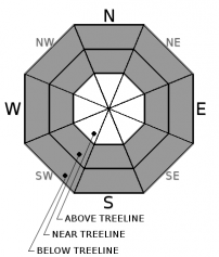
Avalanche Problem 2: Loose Wet
-
Character ?

-
Aspect/Elevation ?
-
Likelihood ?CertainVery LikelyLikelyPossible
Unlikely
-
Size ?HistoricVery LargeLargeSmall
The snowpack has had some time to establish drainage channels for rain on snow. Further, temperatures will fall throughout the day, decreasing the chance of loose wet activity. All said, loose wet avalanche problems will remain possible in the AM and early afternoon hours due to rain soaked snow surfaces below 8,500 feet and very warm temperatures. Any naturally occuring loose wet activity has likely already happened. The majority of any loose wet avalanche activity today is expected to be human triggered. All aspects near and below treeline and on slopes steeper than 35 degrees are subject to loose wet slides. Loose wet avalanches can often move slowly but gain size and speed on larger/longer slopes. Take a close look at the terrain you are on...cliffs, trees and terrain traps can exacerbate the effects of a loose wet avalanche.
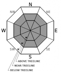
Avalanche Problem 3: Cornice
-
Character ?

-
Aspect/Elevation ?
-
Likelihood ?CertainVery LikelyLikelyPossible
Unlikely
-
Size ?HistoricVery LargeLargeSmall
Large cornices have been observed, mostly in the west side zones of the forecast area. Rain on snow may have caused these cornices to break, or they could just be rain soaked, heavy and ready to go. A trundled cornice can often trigger avalanches on slopes below. Today would be a perfect day for a cornice to trigger a loose wet slide. Stay on terra firma by looking for signs of land...trees, rocks or sticks poking through the snowpack. If none, simply stay back!
Forecast Discussion
I am making an educated guess that most winter enthusiasts have low slung heads this morning after checking in on the weather and backcountry report. It's important to stay positive through this tough time. Catch up on other things in life, enjoy simple pleasures. If you need to fulfill that inner glutton for punishment, a wetsuit (or drysuit) might be the best attire for the day. Loose wet avalanches and/or wet slab avalanches will be the devil of the day below the rain/snow line. Above 8,500 feet, if you so dare to venture, will host high avalanche danger with large wind slabs leading the charge. We are all about folks getting out, getting exercise, regardless of weather conditions... but today, honestly, is not a good day for backcountry travel.
Recent Observations
No new observations came in yesterday over the forecast area. Very...very....VERY wet snow prevails with large, widespread rain runnels. Snow levels have remained near 8,500 feet. Snow depth sensors at our weather stations have reported (warning: explicit language) a decrease in the snowpack of 10-12 inches over the past 24 hours due to rain on snow. ![]()
Temperatures across the land lie in the mid to upper 30's this morning at the 6,500 to 7,500 foot level and rain continues. About 3/4 to 1 inch of rain has fallen since yesterday morning and more is expected today. A lot more. Very strong winds out of the south/southwest will continue as well. It is unknown how things are looking above treeline as we've yet to get good visibility since the onset of this warm storm.
Weather and Current Conditions
Weather Summary
This morning we are in the midst of a high impact rain and wind event. High wind warnings and flood watches and warnings are all in place over Siskiyou County currently, issued by the NWS Medford. Precipitation and wind will continue through today and then begin to taper off into Friday. Following this storm, a cold front will drop temps and snow levels to 3,500 to 4,000 feet on Saturday, however accumulation will be minimal due to low precipitation totals. The weekend will dry out and winds will die off.
===========================================================
In Mt Shasta City at 0500, we have a current temperature of 48 F.
On Mt Shasta (South Side) in the last 24 hours...
Old Ski Bowl - 7,600ft. this station is currently down. We are working on getting it back online ASAP. Nearby at Sand Flat, 6,750 feet, the current temperature is 36 F with .85 inches of rain on snow over the last 24 hours, causing the snowpack to shrink from 111 inches to 102 inches.
Grey Butte - 8,000 feet, the current temperature is 34 degrees F. (Data is limited at this station). Temperatures have ranged from 28 F to 34 F. Winds have averaged 20-25 mph with gusts to 35 mph, blowing west/southwest in nature.
Mt Eddy Range (West side of Interstate-5)...
Castle Lake - 5,800 feet, the current temperature is 38 degrees F. Temperatures have ranged from 34 F to 40 F. Snow on the ground totals 90 inches with only rain on snow resulting in 12 inches of settlement.
Mt Eddy - 6,500 feet, the current temperature is 36 degrees F. Temperatures have ranged from 34 F to 40 F. Snow on the ground measures 84 inches with only rain on snow resulting in 13 inches of settlement. Winds have averaged 2-4 mph with gusts to 25 mph, blowing southerly in nature.
THIS SEASON PRECIPITATION for MT SHASTA CITY: Since October 1st (the wet season), we have received 36.85 inches of water, normal is 24.22 inches, putting us at 152% of normal. For the month of February, we have received 4.59 inches of water, normal is 1.95, which is 235% of normal. And finally for the year of 2017, we received 15.69 inches of water, normal is 9.01 inches, putting us at 174% of normal.
Always check the weather before you attempt to climb Mt Shasta. Further, monitor the weather as you climb. Becoming caught on the mountain in any type of weather can compromise life and limb. Be prepared.
| 0600 temperature: | 36 |
| Max. temperature in the last 24 hours: | 39 |
| Average wind direction during the last 24 hours: | West/Southwest |
| Average wind speed during the last 24 hours: | 20-25 mi/hr |
| Maximum wind gust in the last 24 hours: | 35 mi/hr |
| New snowfall in the last 24 hours: | .85" rain inches |
| Total snow depth: | 102 (-9) inches |
Two Day Mountain Weather Forecast
Produced in partnership with the Medford NWS
| For 7000 ft to 9000 ft | |||
|---|---|---|---|
|
Thursday (4 a.m. to 10 p.m.) |
Thursday Night (10 p.m. to 4 a.m.) |
Friday (4 a.m. to 10 p.m.) |
|
| Weather | Rain. The rain could be heavy at times. Windy. Chance of precipitation is 100%. | Rain and snow showers, becoming all snow after 10pm. Breezy. Chance of precipitation is 100%. | Snow showers. Chance of precipitation is 90%. |
| Temperature (°F) | 42, falling to 35 in afternoon | 27 | 33 |
| Wind (mi/hr) | South/Southwest 25-30 mph | South 15-20 mph | South 10-15 mph |
| Precipitation SWE / Snowfall (in) | / 1-2 (h20-rain) | / 1-3 (snow) | / 3-5 (snow) |
| For 9000 ft to 11000 ft | |||
| Thursday | Thursday Night | Friday | |
| Weather | Snow. The snow could be heavy at times. Wind chill values as low as -7. Windy. Chance of precipitation is 100%. | Snow showers. Wind chill values as low as -13. Windy. Chance of precipitation is 90%. | Snow showers. Wind chill values as low as -12. Windy. Chance of precipitation is 100%. |
| Temperature (°F) | 27, falling to 20 in afternoon | 14 | 14 |
| Wind (mi/hr) | Southwest 50-60 mph | Southwest 15-20 | South 10-20 mph |
| Precipitation SWE / Snowfall (in) | / 15-20 | / 2-4 | / 2-4 |

