

You are here
Avalanche Advisory for 2017-02-10 06:39:09
- EXPIRED ON February 11, 2017 @ 6:39 amPublished on February 10, 2017 @ 6:39 am
- Issued by Nick Meyers - Shasta-Trinity National Forest
Bottom Line
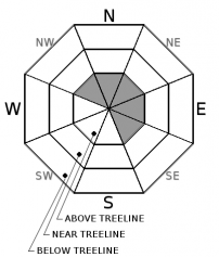
The wind slab avalanche problem above treeline is all that remains after several inches of rain up to 8,500 feet impacted the forecast area over the past 48 hours. Expect CONSIDERABLE avalanche danger for remaining and potentially new wind slabs on primarily N-NE-E facing slopes at mid and upper mountain levels. Rain on snow with cooling temperatures has given way to LOW danger below and near treeline.


Avalanche Problem 1: Wind Slab
-
Character ?

-
Aspect/Elevation ?
-
Likelihood ?CertainVery LikelyLikelyPossible
 Unlikely
 -
Size ?HistoricVery LargeLargeSmall

The wind slab avalanche problem is confined to above treeline terrain only, elevations above 8,500 feet. The largest of wind slabs will exist on wind-loaded N-NE-E aspects and perhaps some cross loading on NW and SE slopes. Remember that on Mt Shasta above 8,500 to 9,000 feet, all this rain has been falling as snow... and potentially several feet of it. Wind slabs, while potentially stubborn to trigger, could be large and devastating.
Small, isolated new wind slabs may form on lower elevation slopes near treeline later today with a few inches of new snow expected.
Beware of slopes previously exposed to wind loading and/or where any new wind loaded snow accumulates today. West/Southwest winds will decrease overall today but still provide 20-30 mph wind speeds and begin to shift to the north tonight into tomorrow.
Forecast Discussion
Based on all things considered yesterday, road access closed, heavy rain to 8,500 feet, Ski Park closed, I would place a friendly bet that not a single person ventured out into the backcountry. I think the activity of choice was river watching and perhaps flood control for those in low lying areas. Loose wet related instabilities will be few today as the rain on snow has done its thing and temperatures have cooled quite a bit. Wind slabs above treeline is our primary avalanche problem.
Recent Observations
If anybody went out yesterday to go for an actual ski, you get a gold star. Mt Shasta received 2.13 inches of rain over the past 24 hours, experienced 8,500-9,000 foot snow levels and west/southwest winds blowing steady 20-30 mph with gusts 50-60 mph. We love being completely transparent: Yesterday, the MSAC spent the day catching up on equipment maintenance and other station duties that have been stacking up. Our field observer made an attempt at Gray Butte, but the Ski Park was closed as was all local backcountry road access and our snowmobiles are in need of repair.
Temperatures have fallen drastically this morning, 14 degrees cooler in Mt Shasta City and 7-9 degrees cooler in the mountains. One might encounter some loose-wet debris out there today, but this avalanche problem has come and gone. We've had a dearth of observations from higher elevations due to extreme weather and low visibility. If the Everitt Memorial Highway opens, folks will likely venture into alpine terrain and should be cautious for remaining wind slabs. Below 9,000 feet, one will likely encounter a heavily rain runneled surface, crust perhaps in areas, and generally funky conditions. A few inches of new snow today may help freshen things up.
Weather and Current Conditions
Weather Summary
The fire hose of moisture that was directed at Mt Shasta over the past two days has shifted south. A reprieve from the torrential downpours yes, but lingering showers will take us through this fine Friday. Temperatures have cooled and will bring snow levels down to 3,500 feet at best. Only a few inches of snow is forecasted for the mountains. Rivers will still need some time to discharge impressive amounts of rain and particularly, rain on snow, so expect the high water to continue. Winds will decrease and give way to a nice looking weekend. Enjoy this respite from the wet weather because it's set to get back in the game, middle of next week sometime.
===========================================================
In Mt Shasta City at 0500, we have a current temperature of 34 F.
On Mt Shasta (South Side) in the last 24 hours...
Old Ski Bowl - 7,600ft. this station is currently down. We are working on getting it back online ASAP. Nearby at Sand Flat, 6,750 feet, the current temperature is 28 F with only rain on snow (2.13" h20) over the last 24 hours. Total height of snow is 98 inches with 4 inches of settlement since yesterday at this time.
Grey Butte - 8,000 feet, the current temperature is 25 degrees F. Temperatures have ranged from 25 F to 34 F. Winds have averaged 20-30 mph with gusts to 56 mph, blowing west/southwest in nature.
Mt Eddy Range (West side of Interstate-5)...
Castle Lake - 5,800 feet, the current temperature is 31 degrees F. Temperatures have ranged from 31 F to 38 F. Snow on the ground totals 86 inches with only rain on snow resulting in 4 inches of settlement.
Mt Eddy - 6,500 feet, the current temperature is 28 degrees F. Temperatures have ranged from 28 F to 36 F. Snow on the ground measures 82 inches with only rain on snow resulting in 2 inches of settlement. Winds have averaged 2-4 mph with gusts to 20 mph, blowing southeast to southwest.
THIS SEASON PRECIPITATION for MT SHASTA CITY: Since October 1st (the wet season), we have received 38.98 inches of water, normal is 24.46 inches, putting us at 159% of normal. For the month of February, we have received 6.72 inches of water, normal is 2.19, which is 306% of normal. And finally for the year of 2017, we received 17.82 inches of water, normal is 9.25 inches, putting us at 192% of normal.
Always check the weather before you attempt to climb Mt Shasta. Further, monitor the weather as you climb. Becoming caught on the mountain in any type of weather can compromise life and limb. Be prepared.
| 0600 temperature: | 28 |
| Max. temperature in the last 24 hours: | 37 |
| Average wind direction during the last 24 hours: | West/Southwest |
| Average wind speed during the last 24 hours: | 20-25 mi/hr |
| Maximum wind gust in the last 24 hours: | 35 mi/hr |
| New snowfall in the last 24 hours: | 2.13" rain inches |
| Total snow depth: | 98 (-4) inches |
Two Day Mountain Weather Forecast
Produced in partnership with the Medford NWS
| For 7000 ft to 9000 ft | |||
|---|---|---|---|
|
Friday (4 a.m. to 10 p.m.) |
Friday Night (10 p.m. to 4 a.m.) |
Saturday (4 a.m. to 10 p.m.) |
|
| Weather | Snow showers. Chance of precipitation is 90%. | Snow showers likely, mainly before 10pm. Chance of precipitation is 70%. | Mostly sunny. |
| Temperature (°F) | 32 | 21 | 36 |
| Wind (mi/hr) | South/Southwest 10-15 mph | North 5-10 mph | North/Northeast 5-10 mph |
| Precipitation SWE / Snowfall (in) | / 2-4 | / 1-2 | / 0 |
| For 9000 ft to 11000 ft | |||
| Friday | Friday Night | Saturday | |
| Weather | Snow showers. Wind chill values as low as -13. Windy. Chance of precipitation is 90%. | Snow showers likely, mainly before 10pm. Mostly cloudy. Wind chill values as low as -11. Windy. Chance of precipitation is 70%. | Mostly sunny. Wind chill values as low as -5. Blustery. |
| Temperature (°F) | 15 | 12 | 23 |
| Wind (mi/hr) | West/Southwest 30-35 mph, decreasing in afternoon | West/Southwest 3-5 | North 10-15 mph |
| Precipitation SWE / Snowfall (in) | / 3-5 | / 1-3 | / 0 |

