

You are here
Avalanche Advisory for 2017-02-13 06:43:06
- EXPIRED ON February 14, 2017 @ 6:43 amPublished on February 13, 2017 @ 6:43 am
- Issued by Andrew Kiefer - Mt Shasta Avalanche Center
Bottom Line
LOW avalanche danger exists in the backcountry. Loose-wet avalanche activity poses the greatest concern on sun-exposed slopes 35 degrees and steeper near and below treeline. The potential for falling rime ice presents a significant objective hazard in the alpine. Watch for changing conditions throughout the day.


Avalanche Problem 1: Loose Wet
-
Character ?

-
Aspect/Elevation ?
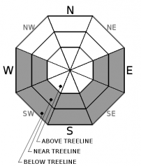
-
Likelihood ?CertainVery LikelyLikelyPossible
 Unlikely
 -
Size ?HistoricVery LargeLargeSmall

Loose-wet activity is possible today on sun exposed slopes near and below treeline. Above treeline, incoming solar radiation has the potential to melt rime ice formations, creating a falling ice hazard. Any wet loose activity today will be confined to the top few inches of the snow surface, and will likely only produce roller balls and small point releases. The loose-wet concerns will likely not be large enough to bury a skier or rider, but have the potential to sweep a person off of their feet and into undesirable terrain.
Forecast Discussion
Generally safe avalanche conditions exist in the backcountry. The duration and intensity of incoming solar radiation will dictate the potential for loose-wet avalanche concerns today. Anticipate changing snow surface conditions, and watch for unconsolidated wet snow on sun exposed slopes 35 degrees and steeper. Clear and mostly sunny skies will continue today and tomorrow before a transition to unsettled weather occurs Wednesday.
Recent Observations
Temperature swings of up to 20 degrees F have occurred above 5500ft during the past 24 hours. Highs have been in the upper 40’s F, and temperatures at the Old Ski Bowl and Grey Butte weather stations remained above freezing overnight. Sunny and clear skies prevailed yesterday, and the snowpack experienced intense solar radiation input. The solar radiation has had the most significant affect on rime ice, melting formations in the alpine and creating a falling ice hazard. Roller balls and small loose-wet activity have occurred over the past 2 days, but have not been large enough to pose a significant threat to backcountry travelers. Easterly winds have blown over the past 48 hours, but have significantly decreased in speed during the past 24 hours, and have become variable. Evidence of wind slab formation has been hard to find. No avalanches or significant signs of instability have occurred since the rain event ending last Thursday.
Weather and Current Conditions
Weather Summary
A ridge of high pressure remains today, and will linger through Tuesday evening. Temperatures inversions are in place this morning, and a thin layer of high-level clouds exists. Skies will be mostly sunny today with calm east winds. Temperatures at the 6000ft level will reach highs in the mid 40’s to lower 50’s. Today and tomorrow look to be the last pleasant weather days before a major pattern shift occurs. Active weather will begin on Wednesday, as another atmospheric river is set to impact northern California. Wet and very windy weather will be the story, with freezing levels up to 9500ft at the onset of the storm. This active storm series looks to continue into next week.
===========================================================
In Mt Shasta City at 0500, we have a current temperature of 33 F with partly cloudy skies skies.
On Mt Shasta (South Side) in the last 24 hours...
Old Ski Bowl - 7,600ft. the current temperture is 37 degrees F. Temperatures have ranged from 32 F to 43 F. Snow on the ground totals 159 inches with no new snow and 1 inch of settlement.
Grey Butte - 8,000 feet, the current temperature is 40 degrees F. Temperatures have ranged from 34 F to 43 F. Winds have averaged 10-20 mph with gusts to 28 mph, blowing primarily out of the east.
Mt Eddy Range (West side of Interstate-5)...
Castle Lake - 5,800 feet, the current temperature is 36 degrees F. Temperatures have ranged from 29 F to 44 F. Snow on the ground totals 84 inches with no new snow and little settlement.
Mt Eddy - 6,500 feet, the current temperature is 38 degrees F. Temperatures have ranged from 26 F to 47 F. Snow on the ground measures 80 inches with no new snow and 1 inch of settlement. Winds have averaged 1-4 mph with gusts to 7 mph, blowing west/southwest.
THIS SEASON PRECIPITATION for MT SHASTA CITY: Since October 1st (the wet season), we have received 39.04 inches of water, normal is 25.17 inches, putting us at 155% of normal. For the month of February, we have received 6.78 inches of water, normal is 2.90, which is 234% of normal. And finally for the year of 2017, we received 17.88 inches of water, normal is 9.96 inches, putting us at 180% of normal.
Always check the weather before you attempt to climb Mt Shasta. Further, monitor the weather as you climb. Becoming caught on the mountain in any type of weather can compromise life and limb. Be prepared.
| 0600 temperature: | 34 |
| Max. temperature in the last 24 hours: | 44 |
| Average wind direction during the last 24 hours: | East |
| Average wind speed during the last 24 hours: | 5-10 mi/hr |
| Maximum wind gust in the last 24 hours: | 15 mi/hr |
| New snowfall in the last 24 hours: | 0 inches |
| Total snow depth: | 94 inches |
Two Day Mountain Weather Forecast
Produced in partnership with the Medford NWS
| For 7000 ft to 9000 ft | |||
|---|---|---|---|
|
Monday (4 a.m. to 10 p.m.) |
Monday Night (10 p.m. to 4 a.m.) |
Tuesday (4 a.m. to 10 p.m.) |
|
| Weather | Mostly sunny | Mostly cloudy | Mostly sunny |
| Temperature (°F) | 47 | 33 | 49 |
| Wind (mi/hr) | East 6 mph | East/Southeast 5-10 mph | South 8 mph |
| Precipitation SWE / Snowfall (in) | / 0 | / 0 | / 0 |
| For 9000 ft to 11000 ft | |||
| Monday | Monday Night | Tuesday | |
| Weather | Mostly sunny | Mostly cloudy and breezy | Mostly sunny |
| Temperature (°F) | 31 | 31 | 35 |
| Wind (mi/hr) | South 5-8 mph | South 0 | South/Southwest 9-13 mph |
| Precipitation SWE / Snowfall (in) | / 0 | / 0 | / 0 |

