

You are here
Avalanche Advisory for 2017-02-19 07:11:34
- EXPIRED ON February 20, 2017 @ 7:11 amPublished on February 19, 2017 @ 7:11 am
- Issued by Andrew Kiefer - Mt Shasta Avalanche Center
Bottom Line
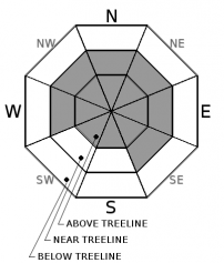
On all aspects near and above treeline, CONSIDERABLE avalanche danger exists. Below treeline, the avalanche danger is MODERATE. Wind slab, storm slab, and cornice fall avalanche problems pose significant concerns for backcountry travelers. A potent storm will impact the advisory area today, bringing heavy snowfall and strong southerly winds. Expect increasing avalanche danger in the backcountry overnight and by tomorrow.


Avalanche Problem 1: Wind Slab
-
Character ?

-
Aspect/Elevation ?
-
Likelihood ?CertainVery LikelyLikelyPossible
 Unlikely
 -
Size ?HistoricVery LargeLargeSmall

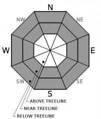
Wind slabs have developed on all aspects above treeline, and W-NW-N-NE-E-SE aspects near treeline. Wind slabs are already 2-4ft thick, and will build in size and distribution today with the addition of new snow and increasing southerly winds. Wind-loaded slopes 35 degrees and steeper pose the greatest risk for avalanches in the backcountry. Be cautious as you gain elevation and transition into terrain affected by the wind. Look for obvious signs of instability like recent avalanches and shooting cracks, and avoid slopes 35 degrees and steeper where evidence of the wind slab problem exists.
Avalanche Problem 2: Storm Slab
-
Character ?

-
Aspect/Elevation ?
-
Likelihood ?CertainVery LikelyLikelyPossible
Unlikely
-
Size ?HistoricVery LargeLargeSmall
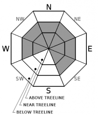
A storm slab large enough to bury, injure, or kill a person was triggered yesterday near treeline. Triggering a storm slab avalanche near or below treeline on all aspects remains possible today. With the additional snow forecast for today and tonight, the risk for both natural and human triggered storm slab avalanches will increase. Stick to simple terrain and supported slopes less then 35 degrees during the storm today and tomorrow.
Avalanche Problem 3: Cornice
-
Character ?

-
Aspect/Elevation ?
-
Likelihood ?CertainVery LikelyLikelyPossible
Unlikely
-
Size ?HistoricVery LargeLargeSmall
Strong and variable winds and over 2ft of recent snow have allowed cornices to form in exposed areas near and above treeline. Be especially careful of the cornice hazard in the Castle Lake and Mt Eddy areas. Be sure to stand back from cornices along ridgelines and avoid terrain threated by cornices from above, as the weight of a fallen cornice can easily trigger a wind slab or storm slab on the slope below.
Forecast Discussion
Just over 2ft of snow has recently been added to our snowpack. Current instabilities all lie within the recent storm snow, and both wind slabs and storm slabs have been human triggered during the past 2 days. Ongoing snowfall will keep the avalanche danger elevated. It is important to choose moderate angled and supported slopes with low consequence today. The most significant precipitation and wind events of this storm series look to impact the area over the next 24-48 hours. By tomorrow, expect to find very dangerous avalanche conditions in the backcountry.
Recent Observations
A break in precipitation occurred during the past 24 hours, and periods of clear skies and sunshine came in waves yesterday. Winds remained light to moderate, and shifted to the west and northwest. The height of the recent snow measured 20-25in between 7000-9000ft on the south side of Mount Shasta.
A skier triggered avalanche occurred yesterday (see photos in Observations below) on a west facing aspect on Gray Butte at 7500ft. The avalanche failed as a storm slab on a density break within the recent snow. The crown was 6-10in deep, 200ft wide, and ran 700ft down the slope. The avalanche was triggered on a steep convex rollover in widely spaced trees.
No other avalanches were observed or reported, besides a few very small point releases in the alpine. The height of new snow was relatively uniform, and no significant wind slabs or cornices were encountered. Wind loaded slopes were visible, however, and plenty of snow is available for transport.
Weather and Current Conditions
Weather Summary
Low pressure off the Pacific Northwest coast will continue to deliver wet and windy weather to Siskiyou County through Tuesday. Today, a trough of low pressure will pass over the advisory area, bringing snow showers and strong southerly winds. Freezing levels will lower to 3500ft during the day, and will raise steadily overnight and tomorrow to 5500ft. Three to six inches of snow is forecast for the 6000ft level and above during the day. An increase in precipitation looks to occur overnight, and continue through tomorrow, bringing just over 2 inches of water to the advisory area by Tuesday morning. Very strong southerly winds are expected during the next 48 hours, along with a warming temperature trend.
===========================================================
In Mt Shasta City at 0500, we have a current temperature of 35 F.
On Mt Shasta (South Side) in the last 24 hours...
Old Ski Bowl - 7,600ft. the current temperture is 20 degrees F. Temperatures have ranged from 19 F to 35 F. Snow on the ground totals 174 inches with no new snow 1 inch of settlement.
Gray Butte - 8,000 feet, the current temperature is 19 degrees F. Temperatures have ranged from 19 F to 32 F. Winds have averaged 10-15 mph with gusts to 35 mph, blowing out of the west/northwest.
Mt Eddy Range (West side of Interstate-5)...
Castle Lake - 5,800 feet, the current temperature is 26 degrees F. Temperatures have ranged from 23 F to 43 F. Snow on the ground totals 101 inches with no new snow and little settlement.
Mt Eddy - 6,500 feet, the current temperature is 24 degrees F. Temperatures have ranged from 22 F to 33 F. Snow on the ground measures 95 inches with no new snow and little settlement. Winds have averaged 1-3 mph with gusts to 12 mph, blowing south/southeast.
THIS SEASON PRECIPITATION for MT SHASTA CITY: Since October 1st (the wet season), we have received 41.09 inches of water, normal is 26.77 inches, putting us at 153% of normal. For the month of February, we have received 8.83 inches of water, normal is 4.50, which is 196% of normal. And finally for the year of 2017, we received 19.93 inches of water, normal is 11.56 inches, putting us at 172% of normal.
Always check the weather before you attempt to climb Mt Shasta. Further, monitor the weather as you climb. Becoming caught on the mountain in any type of weather can compromise life and limb. Be prepared.
| 0600 temperature: | 25 |
| Max. temperature in the last 24 hours: | 33 |
| Average wind direction during the last 24 hours: | E/SE |
| Average wind speed during the last 24 hours: | 5-10 mi/hr |
| Maximum wind gust in the last 24 hours: | 15 mi/hr |
| New snowfall in the last 24 hours: | 0 inches |
| Total snow depth: | 106 inches |
Two Day Mountain Weather Forecast
Produced in partnership with the Medford NWS
| For 7000 ft to 9000 ft | |||
|---|---|---|---|
|
Sunday (4 a.m. to 10 p.m.) |
Sunday Night (10 p.m. to 4 a.m.) |
Monday (4 a.m. to 10 p.m.) |
|
| Weather | Snow showers and breezy. Chance of precipitation 100% | Heavy snow and windy. Chance of precipitation 100%. | Heavy snow and windy. Chance of precipitation is 100%. |
| Temperature (°F) | 33 | 30 | 36 |
| Wind (mi/hr) | South/Southwest 24-26 mph | South 29-34 mph | South 28-31 mph |
| Precipitation SWE / Snowfall (in) | / 3-7 | / 12-18 | / 6-10 |
| For 9000 ft to 11000 ft | |||
| Sunday | Sunday Night | Monday | |
| Weather | Snow showers and windy. Breezy. Wind chill values as low as -18. Chance of precipitation is 100%. | Heavy snow and windy. Wind chill values as low as -9. Chance of precipitation is 100%. | Heavy snow and windy. Wind chill values as low as -9. Chance of precipitation is 100%. |
| Temperature (°F) | 17 | 10 | 20 |
| Wind (mi/hr) | southwest 75-80 mph | Southwest 5-9 | South/Southwest 75-80 mph |
| Precipitation SWE / Snowfall (in) | / 5-9 | / 18-24 | / 18-24 |

