

You are here
Avalanche Advisory for 2017-02-20 07:07:10
- EXPIRED ON February 21, 2017 @ 7:07 amPublished on February 20, 2017 @ 7:07 am
- Issued by Andrew Kiefer - Mt Shasta Avalanche Center
Bottom Line
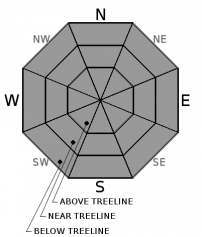
The avalanche danger is HIGH near treeline and above treeline on all aspects. CONSIDERABLE danger exists below treeline. Wind slab, storm slab, and cornice fall avalanches pose significant concerns for backcountry travelers. Natural avalanches are likley, and human-triggered avalanches are very likley. Heavy snowfall and strong southerly winds will continue through tomorrow, keeping the avalanche danger elevated in the backcountry.


Avalanche Problem 1: Storm Slab
-
Character ?

-
Aspect/Elevation ?
-
Likelihood ?CertainVery LikelyLikelyPossible
 Unlikely
 -
Size ?HistoricVery LargeLargeSmall

With 35-40 inches of new snow since last Thursday, storm slabs have formed on all aspects and at all elevations. Storm slabs will build with the additional snowfall expected today and tomorrow. Recent observations indicate the storm slab problem to be very reactive to human triggers, and several density breaks exist within the new snow. Natural storm slab avalanches are likely, and human triggered storm slab avalanches are very likely. Choose moderate angled and supported terrain with low consequence today.
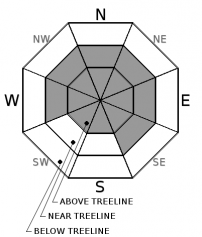
Avalanche Problem 2: Wind Slab
-
Character ?

-
Aspect/Elevation ?
-
Likelihood ?CertainVery LikelyLikelyPossible
Unlikely
-
Size ?HistoricVery LargeLargeSmall
Wind slabs have developed on all aspects above treeline, and W-NW-N-NE-E-SE aspects near treeline. Wind slabs are building in size and distribution today with the addition of new snow and increasing southerly winds. Be cautious as you gain elevation and transition into terrain affected by the wind. Look for obvious signs of instability like recent avalanches and shooting cracks, and avoid slopes 35 degrees and steeper where evidence of the wind slab problem exists.
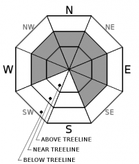
Avalanche Problem 3: Cornice
-
Character ?

-
Aspect/Elevation ?
-
Likelihood ?CertainVery LikelyLikelyPossible
Unlikely
-
Size ?HistoricVery LargeLargeSmall
Strong and variable winds and recent snow have allowed cornices to form in exposed areas near and above treeline. Be especially careful of the cornice hazard in the Castle Lake and Mt Eddy areas. Be sure to stand back from cornices along ridgelines and avoid terrain threated by cornices from above, as the weight of a fallen cornice can easily trigger a storm slab or wind slab on the slope below.
Forecast Discussion
Very dangerous avalanche conditions exist in the backcountry, and ongoing snowfall and gale force winds will keep the danger elevated during the next 48 hours. The potential for large and destructive avalanches exists in the backcountry, and travel in or below avalanche terrain is not recommended. Watch for obvious red flags like recent avalanches, shooting cracks, and collapses. Be especially cautious of wind loaded terrain and slopes where the snow surface feels stiff or slabby. Today is a day to make conservative decisions in the backcountry.
Recent Observations
During the past 24 hours, our remote weather stations report a range of 8-11 inches of new snow, and just under 1 inch of snow water equivalent. Since last Thursday, areas above 6000ft have received 35-40 inches of new snow. After a 24-36 hour lull in precipitation, snowfall began again yesterday around 9am, and has remained steady since. Winds have organized to the south/southwest.
A density break within the recent storm snow produced two skier-triggered avalanches on Gray Butte over the weekend. Yesterday, this same density break was found about 1ft below the snow surface near Ash Creek Butte, and was very reactive. No avalanches were observed. However, skiers initiated several shooting cracks, some extending up to 25ft in length. Large column tests targeting this layer consistently produced full propagation with easy force.
Weather and Current Conditions
Weather Summary
A broad low-pressure system sitting off the Pacific Northwest coast will continue to bring heavy precipitation and strong southerly winds to the advisory area through Tuesday. Today and tonight, freezing levels will be near 5000-5500ft, and will drop to 4500ft by tomorrow. Over the next 48 hours, we are expecting to receive 2.5 inches of water, which will bring heavy rain to lower elevations, and at least 2 additional feet of snow above the 6000ft level. Strong southwest flow will allow for steady gale force winds to blow, and will significantly limit visibility in the mountains. The National Weather Service has issued both a Flood Watch and a Winter Storm Warning for Siskiyou County in effect through Tuesday morning.
===========================================================
In Mt Shasta City at 0500, we have a current temperature of 39 F.
On Mt Shasta (South Side) in the last 24 hours...
Old Ski Bowl - 7,600ft. the current temperture is 26 degrees F. Temperatures have ranged from 19 F to 26 F. Snow on the ground totals 185 inches with 11 inches of new snow and little settlement.
Gray Butte - 8,000 feet, the current temperature is 25 degrees F. Temperatures have ranged from 18 F to 25 F. Winds have averaged 15-25 mph with gusts to 42 mph, blowing out of the southwest.
Mt Eddy Range (West side of Interstate-5)...
Castle Lake - 5,800 feet, the current temperature is 30 degrees F. Temperatures have ranged from 24 F to 31 F. Snow on the ground totals 109 inches with 8 inches of new snow and little settlement.
Mt Eddy - 6,500 feet, the current temperature is 28 degrees F. Temperatures have ranged from 23 F to 30 F. Snow on the ground measures 105 inches with 10 inches of new snow. Winds have averaged 1-3 mph with gusts to 13 mph, blowing south/southwest.
THIS SEASON PRECIPITATION for MT SHASTA CITY: Since October 1st (the wet season), we have received 41.49 inches of water, normal is 27.05 inches, putting us at 153% of normal. For the month of February, we have received 9.23 inches of water, normal is 4.78, which is 193% of normal. And finally for the year of 2017, we received 20.33 inches of water, normal is 11.84 inches, putting us at 172% of normal.
Always check the weather before you attempt to climb Mt Shasta. Further, monitor the weather as you climb. Becoming caught on the mountain in any type of weather can compromise life and limb. Be prepared.
| 0600 temperature: | 30 |
| Max. temperature in the last 24 hours: | 30 |
| Average wind direction during the last 24 hours: | SW |
| Average wind speed during the last 24 hours: | 10-15 mi/hr |
| Maximum wind gust in the last 24 hours: | 20 mi/hr |
| New snowfall in the last 24 hours: | 8 inches |
| Total snow depth: | 114 inches |
Two Day Mountain Weather Forecast
Produced in partnership with the Medford NWS
| For 7000 ft to 9000 ft | |||
|---|---|---|---|
|
Monday (4 a.m. to 10 p.m.) |
Monday Night (10 p.m. to 4 a.m.) |
Tuesday (4 a.m. to 10 p.m.) |
|
| Weather | Snow showers and windy. Chance of precipitation 100% | Heavy snow and windy. Chance of precipitation 100%. | Heavy snow and windy. Chance of precipitation is 100%. |
| Temperature (°F) | 36 | 29 | 31 |
| Wind (mi/hr) | South 33-38 mph | South 21-26 mph, increasing to 35-40 mph after midnight | South 30-32 mph |
| Precipitation SWE / Snowfall (in) | / 9-13 | / 13-19 | / 8-12 |
| For 9000 ft to 11000 ft | |||
| Monday | Monday Night | Tuesday | |
| Weather | Heavy snow and windy. Wind chill values as low as -16. Chance of precipitation is 100%. | Heavy snow and windy. Wind chill values as low as -19. Chance of precipitation is 100%. | Heavy snow and windy. Wind chill values as low as -22. Chance of precipitation is 100%. |
| Temperature (°F) | 21 | 9 | 9 |
| Wind (mi/hr) | Southwest 100+ mph | South/Southwest 22-28 | Southwest 55-60 mph |
| Precipitation SWE / Snowfall (in) | / 22-28 | / 19-25 | / 6-10 |

