

You are here
Avalanche Advisory for 2017-02-21 05:38:43
- EXPIRED ON February 22, 2017 @ 5:38 amPublished on February 21, 2017 @ 5:38 am
- Issued by Andrew Kiefer - Mt Shasta Avalanche Center
Bottom Line
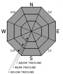
HIGH avalanche danger exists above treeline and near treeline. The avalanche danger is CONSIDERABLE below treeline. Several natural avalanches occurred yesterday, some of which were large enough to bury, injure, or kill a person. Storm slab, wind slab, and cornice fall avalanches remain significant concerns for backcountry travelers. Travel in or below avalanche terrain is not recommend.


Avalanche Problem 1: Storm Slab
-
Character ?

-
Aspect/Elevation ?
-
Likelihood ?CertainVery LikelyLikelyPossible
 Unlikely
 -
Size ?HistoricVery LargeLargeSmall

Three to four feet of new snow have fallen since last Thursday, creating storm slabs on all aspects and at all elevations. Variations in temperature have occurred throughout the storm series, and several density breaks exist within the storm snow. Upside down layering, with heavy dense snow resting on top of lighter, less dense snow, has been found throughout the advisory area. Natural and human triggered storm slab avalanches remain likely.
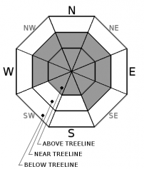
Avalanche Problem 2: Wind Slab
-
Character ?

-
Aspect/Elevation ?
-
Likelihood ?CertainVery LikelyLikelyPossible
Unlikely
-
Size ?HistoricVery LargeLargeSmall
Wind slabs have developed on all aspects above treeline, and W-NW-N-NE-E-SE aspects near treeline. Several natural wind slab avalanches occurred yesterday near Ash Creek Butte. Wind slabs will continue to build in size and distribution today with steady southwest winds and the addition of new snow. Be cautious as you gain elevation and transition into terrain affected by the wind. Look for obvious signs of instability like recent avalanches and shooting cracks, and avoid slopes 35 degrees and steeper where evidence of the wind slab problem exists.
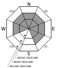
Avalanche Problem 3: Cornice
-
Character ?

-
Aspect/Elevation ?
-
Likelihood ?CertainVery LikelyLikelyPossible
Unlikely
-
Size ?HistoricVery LargeLargeSmall
Strong and variable winds and recent snow have allowed cornices to form in exposed areas near and above treeline. Be especially careful of the cornice hazard in the Castle Lake, Mt Eddy, and Ash Creek Butte areas. Be sure to stand back from cornices along ridgelines and avoid terrain threated by cornices from above, as the weight of a fallen cornice can easily trigger a storm slab or wind slab on the slope below.
Forecast Discussion
Storm slab, wind slab, and cornice fall avalanches all occurred naturally or were human triggered yesterday. Dangerous avalanche conditions exist in the backcountry. The avalanche hazard will remain elevated while the snowpack adjusts to the rapid load of new snow during the storm. Look for signs of instability like recent avalanches, shooting cracks, and collapses. Choose lower angled terrain and supported slopes with low consequence today. Avalanches could be large and destructive, and avalanche run out zones should be avoided.
Recent Observations
Several cornice triggered wind slab avalanches up to size 2 occurred naturally yesterday morning near Ash Creek Butte (see photos in Observations). The avalanches ran near treeline on northerly aspects. The crowns were 1-2ft thick, up to 150ft wide, and ran as far as 700ft downslope.
On the south side of Mount Shasta near Bunny Flat, one shallow and very small storm slab was triggered by a plow along the Everitt Memorial highway yesterday. Otherwise, no avalanches, shooting cracks or collapses were observed during a tour to Horse Camp and near by areas. Several density breaks were found within the top 3ft of new snow since 02/16. These density breaks did not propagate in large column tests, and they produced sudden planar and resistant planar fractures in small column tests. In areas 7600ft and below, a rain crust was found about 1ft below the snow surface. In areas above this elevation, a more pronounced upside down layering configuration was found, with dense heavy snow resting on top of lighter, less dense snow.
Weather and Current Conditions
Weather Summary
The most recent low-pressure system is pushing south and its effects on our forcast area are diminishing. Expect a trace of snow today and clearing tonight with calm winds. Snow levels will remain low (1000-1500') for the next couple of days. A third low followed by a cold front will bring renewed precipitation in the form of snow tomorrow. Dryer and slightly warmer conditions (3500 snow level) are expected to prevail after Monday.
===========================================================
In Mt Shasta City at 0500, we have a current temperature of 28 F.
On Mt Shasta (South Side) in the last 24 hours...
Old Ski Bowl - 7,600ft, the current temperture is 25 degrees F. Temperatures have ranged from 25 F to 30 F. Snow on the ground totals 196 inches with 11 inches of new snow and 1.35 inches of snow water equivalent.
Gray Butte - 8,000 feet, the current temperature is 25 degrees F. Temperatures have ranged from 25 F to 29 F. Winds have averaged 15-30 mph with gusts to 64 mph, blowing out of the west/southwest.
Mt Eddy Range (West side of Interstate-5)...
Castle Lake - 5,800 feet, the current temperature is 30 degrees F. Temperatures have ranged from 30 F to 35 F. Snow on the ground totals 114 inches with 5 inches of new snow and little settlement.
Mt Eddy - 6,500 feet, the current temperature is 28 degrees F. Temperatures have ranged from 28 F to 33 F. Snow on the ground measures 114 inches with 9 inches of new snow. Winds have averaged 1-3 mph with gusts to 27 mph, blowing south/southwest.
THIS SEASON PRECIPITATION for MT SHASTA CITY: Since October 1st (the wet season), we have received 42.88 inches of water, normal is 27.33 inches, putting us at 156% of normal. For the month of February, we have received 10.62 inches of water, normal is 5.06, which is 210% of normal. And finally for the year of 2017, we received 21.72 inches of water, normal is 12.12 inches, putting us at 179% of normal.
Always check the weather before you attempt to climb Mt Shasta. Further, monitor the weather as you climb. Becoming caught on the mountain in any type of weather can compromise life and limb. Be prepared.
| 0600 temperature: | 29 |
| Max. temperature in the last 24 hours: | 33 |
| Average wind direction during the last 24 hours: | SW |
| Average wind speed during the last 24 hours: | 10-15 mi/hr |
| Maximum wind gust in the last 24 hours: | 25 mi/hr |
| New snowfall in the last 24 hours: | 8 inches |
| Total snow depth: | 122 inches |
Two Day Mountain Weather Forecast
Produced in partnership with the Medford NWS
| For 7000 ft to 9000 ft | |||
|---|---|---|---|
|
Tuesday (4 a.m. to 10 p.m.) |
Tuesday Night (10 p.m. to 4 a.m.) |
Wednesday (4 a.m. to 10 p.m.) |
|
| Weather | Snow showers and breezy. Chance of precipitation 100% | 50% chance of snow showers. | Snow showers likely. Chance of precipitation is 80%. |
| Temperature (°F) | 30 | 21 | 26 |
| Wind (mi/hr) | South/Southwest 22-28 mph | South/Southwest 10-15 mph | West/Northwest 5-8 mph |
| Precipitation SWE / Snowfall (in) | / 2-4 | / 3-5 | / 2-4 |
| For 9000 ft to 11000 ft | |||
| Tuesday | Tuesday Night | Wednesday | |
| Weather | Snow showers and windy. Wind chill values as low as -19. Chance of precipitation is 100%. | Chance snow showers and windy. Wind chill values as low as -20. Chance of precipitation is 50%. | Snow showers likely. Cloudy and cold. Wind chill values as low as -23. Chance of precipitation is 70%. |
| Temperature (°F) | 9 | 4 | 4 |
| Wind (mi/hr) | West/Southwest 37-46 mph | West/Southwest 3-7 | West/Northwest 13-18 mph |
| Precipitation SWE / Snowfall (in) | / 3-7 | / 3-5 | / 2-4 |

