

You are here
Avalanche Advisory for 2017-02-25 07:00:03
- EXPIRED ON February 26, 2017 @ 7:00 amPublished on February 25, 2017 @ 7:00 am
- Issued by Aaron Beverly - Mount Shasta Avalanche Center
Bottom Line
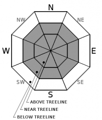
The overall avalanche danger remains MODERATE today, near treeline and above treeline. The most dangerous places are at mid and upper mountain levels where 6-8 inches of light density snow has or will be wind transported onto leeward ridgelines and tops of bowls. Calm winds are expected today but pay attention to any blowing snow! Avoid those leeward slopes for maximum safety. Be aware of triggering loose sloughs on steeper aspects. Below treeline, the avalanche danger is LOW.


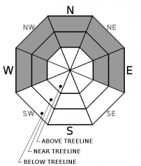
Avalanche Problem 1: Wind Slab
-
Character ?

-
Aspect/Elevation ?
-
Likelihood ?CertainVery LikelyLikelyPossible
 Unlikely
 -
Size ?HistoricVery LargeLargeSmall

Although wind loaded areas near treeline yesterday yielded stable results in tests, human triggered wind slabs are still possible today near treeline and above treeline. Loading has occurred predominantly on eastern to northerly aspects in the last few days. New wind slabs are shallow but could propagate across a large area. Winds should remain calm today but keep an eye out for blowing snow to identify new areas of loading. There is 6-8 inches of light low denisty snow available for transport.
Avalanche Problem 3: Loose Dry
-
Character ?

-
Aspect/Elevation ?
-
Likelihood ?CertainVery LikelyLikelyPossible
Unlikely
-
Size ?HistoricVery LargeLargeSmall
Loose snow sluffs were observed on northerly aspects yesterday where light low denisty snow was not bonded well to firmer snow beneath. With continuing cold temps and calm winds, this concern will remain for the next couple of days. Expect to see these conditions where the coldest and least cohesive snow exists on NW-N-NE-E aspects below and near treeline. It is not expected for these avalanches to be a serious threat.
Forecast Discussion
With cold temperatures and calm winds and around 2 inches of snow since yesterday, little has changed in the conditions of the snow pack. Stability generally is looking good, with no concerning failues in snowpit tests conducted on a windloaded aspect of Grey Butte. Concern still lies for any new wind transport of our 6-8 inches of light density snow that sits atop of the snowpack. New wind slabs on leeward slopes will be the top concern for any riders or sliders in the backcountry today. Expect snow sloughs on steeper aspects where the light density snow has not bonded with the firmer layer beneath.
Recent Observations
Calm winds and cold temperatures led to a magical day on Grey Butte yesterday with about 4-6 inches of light low density snow atop a firmer layer beneath. Recent wind loading has occured on easterly to northerly aspects. Cornices were stiff, hard to break, but definitely overhung and not advisable to walk on. Loose sloughs were easily produced on steeper aspects.
Two test pits were dug on northeasterly aspects near 8000'. On a sheltered aspect, there was 10 cm of new snow, and the snow depth on the old rain crust was 88 cm and trending to right side up. CT12@23cm RP, ECTN12@23cm BKN failing below a 1F 4 cm layer of snow. On a windloaded aspect, height of snow atop the old rain crust was 132cm with 15cm of new light low density snow. ECTN12 @ 22 cm BKN, ECTN14 @ 29cm BKN.
Weather and Current Conditions
Weather Summary
The most recent low is pushing to the south, and it`s effects on the forecast area are diminishing. Expect a trace of snow today with partly sunny conditions and low temperatures. Snow levels will remain low (2500'). A new low followed by a cold front will bring new precipitation in the form of snow above 2500' on Sunday. Expect dryer and warming conditions after Monday through the remaining week.
===========================================================
In Mt Shasta City at 0500, we have a current temperature of 27 F.
On Mt Shasta (South Side) in the last 24 hours...
Old Ski Bowl - 7,600ft, the current temperture is 11 degrees F. Temperatures have ranged from 2 F to 24 F. Snow on the ground totals 193 inches with 2 inches of new snow and about 1 inch of settlement
Gray Butte - 8,000 feet, the current temperature is 12 degrees F. Temperatures have ranged from 5 F to 21 F. Winds have been mostly westerly (WNW, WSW) and bit out of the SW, light, averaging 8 mph/gust-21 mph.
Mt Eddy Range (West side of Interstate-5)...
Castle Lake - 5,800 feet, the current temperature is 17 degrees F. Temperatures have ranged from 13 F to 38 F. Snow on the ground totals 110 inches with a trace of new snow and 1 inch of settlement.
Mt Eddy - 6,500 feet, the current temperature is 13 degrees F. Temperatures have ranged from 4 F to 22 F. Snow on the ground measures 112 inches with 1-2 inches of new snow and 1.5 inches of settlement. Winds have been calm, averaging 3 mph with gusts to 9 mph, blowing WSW to ESE.
THIS SEASON PRECIPITATION for MT SHASTA CITY: Since October 1st (the wet season), we have received 43.25 inches of water, normal is 28.42 inches, putting us at 152% of normal. For the month of February, we have received 10.99 inches of water, normal is 6.15, which is 179% of normal. And finally for the year of 2017, we received 22.09 inches of water, normal is 13.21 inches, putting us at 167% of normal.
Always check the weather before you attempt to climb Mt Shasta. Further, monitor the weather as you climb. Becoming caught on the mountain in any type of weather can compromise life and limb. Be prepared.
Always check the weather before you attempt to climb Mt Shasta. Further, monitor the weather as you climb. Becoming caught on the mountain in any type of weather can compromise life and limb. Be prepared.
| 0600 temperature: | 11 |
| Max. temperature in the last 24 hours: | 25 |
| Average wind direction during the last 24 hours: | W-NW-SW |
| Average wind speed during the last 24 hours: | 8 mi/hr |
| Maximum wind gust in the last 24 hours: | 12 mi/hr |
| New snowfall in the last 24 hours: | 2 inches |
| Total snow depth: | 122 inches |
Two Day Mountain Weather Forecast
Produced in partnership with the Medford NWS
| For 7000 ft to 9000 ft | |||
|---|---|---|---|
|
Saturday (4 a.m. to 10 p.m.) |
Saturday Night (10 p.m. to 4 a.m.) |
Sunday (4 a.m. to 10 p.m.) |
|
| Weather | 30% chance of snow, partly sunny | 10% chance of snow, partly cloudy | 80% chance of snow after 10am |
| Temperature (°F) | 28 | 15-20 | 25-30 |
| Wind (mi/hr) | South - Southeast 5 mph | North changing to Southwest 5 mph | Southwest 5-10 mph |
| Precipitation SWE / Snowfall (in) | / 0-1 | / 0 | / 1-3 |
| For 9000 ft to 11000 ft | |||
| Saturday | Saturday Night | Sunday | |
| Weather | 30% chance of snow, partly sunny | Partly cloudy, wind chill as low as -17 F. | 80% chance of snow after 10am, wind chill as low as -28. |
| Temperature (°F) | 6 | 12 | 11 |
| Wind (mi/hr) | West/Southwest 5-10 mph | Southwest 0-1 | North 5-10 mph |
| Precipitation SWE / Snowfall (in) | / 0-1 | / 0 | / 3-5 |

