

You are here
Avalanche Advisory for 2017-02-27 06:45:49
- EXPIRED ON February 28, 2017 @ 6:45 amPublished on February 27, 2017 @ 6:45 am
- Issued by Aaron Beverly - Mount Shasta Avalanche Center
Bottom Line
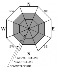
This morning the avalanche danger is CONSIDERABLE near and above treeline due to wind slab formation on leeward aspects. Pay attention to where the snow is blowing and avoid slopes above 30 degrees where loading has occurred. Loose sloughs are still possible in areas where low density snow remains unbonded to the firmer layer beneath. Because of some shallow storm slabs observed yesterday, avalanche danger below treeline is MODERATE on steeper slopes.


Avalanche Problem 1: Wind Slab
-
Character ?

-
Aspect/Elevation ?
-
Likelihood ?CertainVery LikelyLikelyPossible
 Unlikely
 -
Size ?HistoricVery LargeLargeSmall

The last 24 hours saw wind speeds in the 20's and gusts up to 35, plenty of wind to transport snow. With higher winds predicted above treeline today and plenty of light snow available for transport, expect wind slab formation at and above treeline on leeward aspects. Predominant loading is expected on east and southeast facing slopes, but mountain winds can be variable so pay attention whenever entering steep terrain.
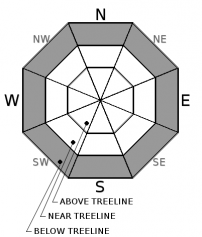
Avalanche Problem 2: Storm Slab
-
Character ?

-
Aspect/Elevation ?
-
Likelihood ?CertainVery LikelyLikelyPossible
Unlikely
-
Size ?HistoricVery LargeLargeSmall
A couple of small shallow storm slabs were observed above Bunny Flat yesterday afternoon. Storms slabs typically occur on a snow density break within the new storm snow. Keep an eye out for them on steeper slopes below treeline where new snow has settled and consolidated.
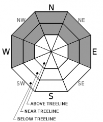
Avalanche Problem 3: Loose Dry
-
Character ?

-
Aspect/Elevation ?
-
Likelihood ?CertainVery LikelyLikelyPossible
Unlikely
-
Size ?HistoricVery LargeLargeSmall
Expect loose dry instabilities where the coldest and least cohesive snow exists on NW-N-NE-E aspects below and near treeline. It is not expected for these avalanches to be a serious threat but could sweep a rider off their feet and into undesireable terrain.
Forecast Discussion
The primary concern today is wind slab formation near and above treeline. Winds have been in the twenties and blowing from the W and NW and moderate to strong NW winds will continue today and tomorrow. Concern is predominantly on east to southeast aspects, but wind slabs could exist on other aspects particularly above treeline where moutain winds can be unpredictable.
Of secondary concern are storm slabs below treeline. These were observed yesterday afternoon above Bunny Flat. Since very little new snow has fallen in the last 48 hours, these may due to a layer of settled new snow atop the firmer layer beneath.
Recent Observations
Lower elevations including Castle Lake saw some above freezing temperatures yesterday leading to heavy surface snow and may lead to a melt-freeze crust today. The gate at Castle Lake Rd. is still closed and snowmobiling up the road is not an option.
Some windloading and shallow storm slabs were observed above Bunny Flat late yesterday afternoon.
Weather and Current Conditions
Weather Summary
The remains of the low pressure system moving through will continue to keep things cold and snow levels below 2000' today and tomorrow with diminishing chances of precipitation. After Tuesday, the effects of a high pressure system will bring wamer air and rising snow levels (> 5000'). Expect clearer, warmer, and dryer weather until the weekend.
===========================================================
In Mt Shasta City at 0500, we have a current temperature of 16 F.
On Mt Shasta (South Side) in the last 24 hours...
Old Ski Bowl - 7,600ft, the current temperture is 12 degrees F. Temperatures have ranged from 2 F to 20 F. Snow on the ground totals 192 inches with .5 inches of new snow and .25 inches of settlement
Gray Butte - 8,000 feet, the current temperature is 9 degrees F. Temperatures have ranged from 5 F to 20 F. Winds have been predominantly WNW-NW averaging 15 mph with gusts to 35 mph.
Mt Eddy Range (West side of Interstate-5)...
Castle Lake - 5,800 feet, the current temperature is 15 degrees F. Temperatures have ranged from 14 F to 38 F. Snow on the ground totals 111 with 1 inch of new snow and 2 inches of settlement.
Mt Eddy - 6,500 feet, the current temperature is 13 degrees F. Temperatures have ranged from 9 F to 25 F. Snow on the ground measures 112 inches with 2 inches of new snow and 1.5 inches of settlement. Winds have been calm, averaging 2 mph with gusts up to 11, and variable.
THIS SEASON PRECIPITATION for MT SHASTA CITY: Since October 1st (the wet season), we have received 43.31 inches of water, normal is 28.96 inches, putting us at 150% of normal. For the month of February, we have received 11.05 inches of water, normal is 6.69, which is 165% of normal. And finally for the year of 2017, we received 22.15 inches of water, normal is 13.75 inches, putting us at 161% of normal.
Always check the weather before you attempt to climb Mt Shasta. Further, monitor the weather as you climb. Becoming caught on the mountain in any type of weather can compromise life and limb. Be prepared.
| 0600 temperature: | 11 |
| Max. temperature in the last 24 hours: | 20 |
| Average wind direction during the last 24 hours: | WNW-NW |
| Average wind speed during the last 24 hours: | 15 mi/hr |
| Maximum wind gust in the last 24 hours: | 35 mi/hr |
| New snowfall in the last 24 hours: | .5 inches |
| Total snow depth: | 120 inches |
Two Day Mountain Weather Forecast
Produced in partnership with the Medford NWS
| For 7000 ft to 9000 ft | |||
|---|---|---|---|
|
Monday (4 a.m. to 10 p.m.) |
Monday Night (10 p.m. to 4 a.m.) |
Tuesday (4 a.m. to 10 p.m.) |
|
| Weather | Snow showers likely between 10 a.m and 4 p.m. Mostly cloudy. Chance of precipitation is 70%. | Snow showers, mainly before 10 pm. Mostly cloudy. Chance of precipitation is 50%. | Chance of snow showers 20%. Partly sunny. |
| Temperature (°F) | 29 | 17 | 29 |
| Wind (mi/hr) | Southwest 7-9 mph | West 6-7 mph | Southwest 4-7 mph |
| Precipitation SWE / Snowfall (in) | / 1 | / <1 | / <1 |
| For 9000 ft to 11000 ft | |||
| Monday | Monday Night | Tuesday | |
| Weather | Cloudy and cold. Snow showers likely. 70% chance of precipitation | Mostly cloudy. Snow showers possible before 10. Chance of precipitation 50% | Partly sunny. 20% chance of snow. |
| Temperature (°F) | 12 | 4 | 7 |
| Wind (mi/hr) | Northwest/West 18-25 mph | Northwest 1-3 | Northwest 20-28 mph |
| Precipitation SWE / Snowfall (in) | / 1-3 | / 1-2 | / <1 |

