

You are here
Avalanche Advisory for 2017-03-10 06:07:06
- EXPIRED ON March 11, 2017 @ 6:07 amPublished on March 10, 2017 @ 6:07 am
- Issued by Nick Meyers - Shasta-Trinity National Forest
Bottom Line
Continued warming temperatures and poor overnight refreeze has lead to an increasing chance of loose-wet avalanches today. The avalanche danger could rise to MODERATE as loose wet avalanches become possible. Long, steep slopes such as on Mt Shasta provide the potential for loose wet avalanches to gain significant size. These avalanches could host enough snow to bury a person. If you observe loose wet instabilities, move to a shadier or lower angle slope.


Avalanche Problem 1: Loose Wet
-
Character ?

-
Aspect/Elevation ?
-
Likelihood ?CertainVery LikelyLikelyPossible
 Unlikely
 -
Size ?HistoricVery LargeLargeSmall

A warming trend with above freezing temperatures over the past 24 hours has lead to an increasing chance of consequential loose wet instabilities today. These loose wet instabilities could take the form of roller balls, pinwheels or potentially larger loose wet avalanches. Loose wet avalanches involved the surface layers of the snowpack and can gain significant size and mass, entraining more snow as they move down the hill. Long, steep slopes allow for significant snow accumulation. Terrain traps will magnify the consequences. Signs of loose wet instability include roller balls, pinwheels and sinking into moist/wet snow above your boot tops. These are signs that the snow is loosing cohesion. A safe choice would be to avoid steep slopes that host these characteristics.
Forecast Discussion
It's almost the time of year when we can put our flip flops on after a day of skiing. Our warmest temperatures we've seen since October are upon us and some may say Spring is in the air. We are not throwing in the towel yet...but for the time being, yes it is warm. We've now had 48 hours of mostly above freezing temperatures and as a result, there in an increasing chance of loose wet related instabilities today. Loose snow avalanches usually start from a point and fan outward as they descend, and because of this they are also called “point releases.” Very few people are killed by loose snow avalanches because they tend to be small and they tend to fracture beneath you as you cross a slope instead of above you as slab avalanches often do. The avalanche culture tends to minimize the danger of loose snow avalanches, sometimes calling them "harmless sluffs." But, of course, this is not always the case. Houses have been completely destroyed by "harmless sluffs," and if caught in one, it can easily take the victim over cliffs, into crevasses or bury them deeply in a terrain trap such as a gully. Most of the people killed in sluffs are climbers who are caught in naturally-triggered sluffs that descend from above--especially in wet or springtime conditions.
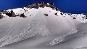
Example of loose wet avalanches off southeasterly aspect of Casaval Ridge, taken last year. Skiers and climbers often ascend directly below this aspect...not always a good choice.
Recent Observations
As of this morning, temperatures are a few degrees warmer than yesterday at this time. Daytime highs continue to climb as well. Last night, above freezing temperatures were widespread. The only weather station to reach 32 degrees was Sand Flat. Gray Butte, at 8,000 feet, had a low of 34 degrees F. It's likely that the freezing level was about 8,500 to 9,000 feet. The snowpack continues to settle, several inches over the past 24 hours. Winds have been light to moderate below and near treeline. Above treeline, steady west/northwest wind, averaging 20 mph with gusts into the 40's has been observed. We've seen some minor roller ball action on easterly and southerly slopes below 9,500 feet, but no other major signs of instability or recent avalanches. The snowpack remains moist and variable conditions prevail.
Weather and Current Conditions
Weather Summary
We are in a heat wave! Temperatures have climbed an additional couple degrees this morning and will remain very mild through next week. Expected are some of the warmest daytime highs since October. This pattern will continue for the near future, however models suggest another round of storms near the middle of the month. At this point, snow levels are agonizingly high. More on that later. Today... yes, warm with partly cloudy skies. Winds will remain calm at lower elevations and do not look to bad above treeline either. It's likely that this balmy weather be will begin to get most to start thinking about Spring. Enjoy the day!
===========================================================
In Mt Shasta City at 0500, we have a current temperature of 43 F.
On Mt Shasta (South Side) in the last 24 hours...
Sand Flat - 6750 ft, the current temperture is 38 degrees F. Temperatures have ranged from 32 F to 45 F. Snow on the ground totals 115 inches with no new snow and 2 inches of settlement.
Old Ski Bowl - 7,600ft. the current temperture is 39 degrees F. Temperatures have ranged from 35 F to 42 F. Snow on the ground totals 190 inches with no new snow and 3 inches of settlement.
Gray Butte - 8,000 feet, the current temperature is 37 degrees F. Temperatures have ranged from 34 F to 39 F. Winds have averaged 20 mph with gusts to 49 out of the west/northwest.
Mt Eddy Range (West side of Interstate-5)...
Castle Lake - 5,800 feet, the current temperature is 39 degrees F. Temperatures have ranged from 39 F to 54 F. Snow on the ground totals 112 inches with no new snow and 5 inches of settlement.
Mt Eddy - 6,500 feet, the current temperature is 38 degrees F. Temperatures have ranged from 36 F to 50 F. Snow on the ground measures 105 inches with no new snow and 1 inch of settlement. Winds have been variable, averaging 1-2 mph with gusts to 8 mph.
THIS SEASON PRECIPITATION for MT SHASTA CITY: Since October 1st (the wet season), we have received 43.67 inches of water, normal is 31.69 inches, putting us at 137% of normal. For the month of March, we have received .36 inches of water, normal is 2.19 inches, which is 16% of normal. And finally for the year of 2017, we received 22.51 inches of water, normal is 16.48 inches, putting us at 136% of normal.
Always check the weather before you attempt to climb Mt Shasta. Further, monitor the weather as you climb. Becoming caught on the mountain in any type of weather can compromise life and limb. Be prepared.
| 0600 temperature: | 38 |
| Max. temperature in the last 24 hours: | 45 |
| Average wind direction during the last 24 hours: | West/Northwest |
| Average wind speed during the last 24 hours: | 15-20 mi/hr |
| Maximum wind gust in the last 24 hours: | 49 (Gray Butte) mi/hr |
| New snowfall in the last 24 hours: | 0 inches |
| Total snow depth: | 115 inches |
Two Day Mountain Weather Forecast
Produced in partnership with the Medford NWS
| For 7000 ft to 9000 ft | |||
|---|---|---|---|
|
Friday (4 a.m. to 10 p.m.) |
Friday Night (10 p.m. to 4 a.m.) |
Saturday (4 a.m. to 10 p.m.) |
|
| Weather | Very slight chance at light showers this morning, otherwise, mostly cloudy this morning, gradually becoming sunny. | Partly cloudy | Partly sunny |
| Temperature (°F) | 49 | 35 | 51 |
| Wind (mi/hr) | East/Northeast becoming northwest 5-10mph | North, becoming east 5-10mph | East, becoming west 5-10mph |
| Precipitation SWE / Snowfall (in) | / 0 | / 0 | / 0 |
| For 9000 ft to 11000 ft | |||
| Friday | Friday Night | Saturday | |
| Weather | Mostly cloudy, isolated rain showers this morning, then partly cloudy in afternoon | Mostly clear in the evening, then becoming partly cloudy. | Partly cloudy in the morning, then becoming mostly cloudy |
| Temperature (°F) | 31 | 31 | 33 |
| Wind (mi/hr) | West 25-30 mph | West 0 | West 20-25 mph |
| Precipitation SWE / Snowfall (in) | / 0 | / 0 | / 0 |

