

You are here
Avalanche Advisory for 2017-03-16 06:45:00
- EXPIRED ON March 17, 2017 @ 6:45 amPublished on March 16, 2017 @ 6:45 am
- Issued by Aaron Beverly - Mount Shasta Avalanche Center
Bottom Line
Avalanche danger above 9000 feet is MODERATE due to the potential for wind slab avalanches. Avoid wind loaded slopes greater than 30 degrees. Below treeline, expect a wet heavy snowpack that could lead to loose wet slides. Below and at treeline, the avalanche danger is LOW. LOW means unlikely, but not impossible, so stay vigilant if you are sinking beyond your boot cuffs. You may be near loose wet avalanche terrain.


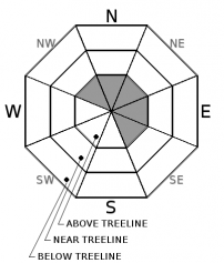
Avalanche Problem 1: Wind Slab
-
Character ?

-
Aspect/Elevation ?
-
Likelihood ?CertainVery LikelyLikelyPossible
 Unlikely
 -
Size ?HistoricVery LargeLargeSmall

No verification of snow accumulation above treeline was received yesterday, but the Old Ski Bowl recorded .75 inches of rain. This could translate to 7 - 9 inches of snow. Snow levels were at least 8000'. With moderate to strong SW winds, it is likely wind slabs formed on leeward slopes above 9000' where snow may have been light enough to be blown by the wind. With strong southwest winds expected today, wind slabs may continue to form and could reach as thick as 18 inches or more. A wind slab is a cohesive layer of snow formed when wind deposits snow onto leeward terrain. Wind slabs are often smooth and rounded and sometimes sound hollow. Look for shooting cracks as indicators of the presence of this avalanche problem. Avoid wind loaded aspects greater than 30 degrees when traveling above 9000'.
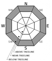
Avalanche Problem 2: Loose Wet
-
Character ?

-
Aspect/Elevation ?
-
Likelihood ?CertainVery LikelyLikelyPossible
Unlikely
-
Size ?HistoricVery LargeLargeSmall
Soft snow, above freezing temperatures, and rain have combined to create a heavy sloppy snow pack below treeline and could lead to loose wet avalanches on steeper slopes. A loose wet avalanche is a release of unconsolidated snow or slush. It starts at a point and entrains snow as it moves downhill. A terrain trap such as a gully, cliff, or an abrupt slope transition can significantly magnify the consequences of being caught in one of these. Colder temperatures near treeline have probably reduced the likelihood of these up higher, but always be vigilant. Pay attention to ski and boot penetration. If you are sinking to your boot cuff or further, you should to stay clear of slopes greater than 30 degrees.
Recent Observations
Pouring rain was the seen at the ski park for most of the afternoon at the top of all lifts. Off-piste snow was very soft and boot penetration was at least calf-deep. No loose wet slides could be triggered in test areas.
The Old Ski Bowl weather station received about 3/4 inches of rain and no snow putting snow levels above 7600'. Temperatures reached just below freezing at 8000' during the period of precipitation.
Weather and Current Conditions
Weather Summary
Enjoy a short respite from the rain today and tomorrow. Snow levels will drop briefly to 6500 feet this morning and then shoot back up to at least 8500' as a low pressure trough in the eastern Pacific brings warmer air into region early on Friday. Saturday will see more wet weather that will continue throughout next week. Expect up to a 1/2 an inch of rain by Monday. Models indicate snow levels may drop below 5000' by the middle of next week.
===========================================================
In Mt Shasta City at 0500, we have a current temperature of 44 F.
On Mt Shasta (South Side) in the last 24 hours...
Sand Flat - 6750 ft, the current temperture is 33 degrees F. Temperatures have ranged from 33 F to 43 F. Snow on the ground totals 102 inches with no new snow and 2 inches of settlement.
Old Ski Bowl - 7,600ft. the current temperature is 32 degrees F. Temperatures have ranged from 32 F to 39 F. Snow on the ground totals 176 inches with an inch of new and an inch of settlement. About 3/4 of an inch of rain was received.
Gray Butte - 8,000 feet, the current temperature is 32 degrees F. Temperatures have ranged from 32 F to 41 F. Winds have averaged 16 mph with gusts to 35 mph out of the west and southwest.
Mt Eddy Range (West side of Interstate-5)...
Castle Lake - 5,800 feet, the current temperature is 35 degrees F. Temperatures have ranged from 35 F to 45 F. Snow on the ground totals 101 inches with no new snow and 3 inches of settlement.
Mt Eddy - 6,500 feet, the current temperature is 33 degrees F. Temperatures have ranged from 33 F to 42 F. Snow on the ground measures 93 inches with no new snow and 4 inches of settlement. Winds have averaged 2 mph with gusts to 13 mph blowing out of the south.
THIS SEASON PRECIPITATION for MT SHASTA CITY: Since October 1st (the wet season), we have received 43.91 inches of water, normal is 33.0 inches, putting us at 133% of normal. For the month of March, we have received .6 inches of water, normal is 3.50 inches, which is 17% of normal. And finally for the year of 2017, we received 22.75 inches of water, normal is 17.79 inches, putting us at 128% of normal.
Always check the weather before you attempt to climb Mt Shasta. Further, monitor the weather as you climb. Becoming caught on the mountain in any type of weather can compromise life and limb. Be prepared.
| 0600 temperature: | 33 |
| Max. temperature in the last 24 hours: | 43 |
| Average wind direction during the last 24 hours: | West to southwest |
| Average wind speed during the last 24 hours: | 16 mi/hr |
| Maximum wind gust in the last 24 hours: | 35 mi/hr |
| New snowfall in the last 24 hours: | 0 inches |
| Total snow depth: | 102 inches |
Two Day Mountain Weather Forecast
Produced in partnership with the Medford NWS
| For 7000 ft to 9000 ft | |||
|---|---|---|---|
|
Thursday (4 a.m. to 10 p.m.) |
Thursday Night (10 p.m. to 4 a.m.) |
Friday (4 a.m. to 10 p.m.) |
|
| Weather | A 20 percent chance of snow showers before 11am. Mostly cloudy Breezy. | Mostly cloudy | Mostly cloudy. Breezy. |
| Temperature (°F) | 46 | 32 | 48 |
| Wind (mi/hr) | South Southwest 5-10 mph | South 5-10 mph | South 10-15 mph |
| Precipitation SWE / Snowfall (in) | / 0 | / 0 | / 0 |
| For 9000 ft to 11000 ft | |||
| Thursday | Thursday Night | Friday | |
| Weather | A 20 percent chance of snow showers before 11am. Partly sunny. | Mostly cloudy. Breezy. | Mostly cloudy. Windy. |
| Temperature (°F) | 27 | 26 | 32 |
| Wind (mi/hr) | Southwest 30-35 | Southwest 0 | Southwest 40 mph |
| Precipitation SWE / Snowfall (in) | / 0 | / 0 | / 0 |

