

You are here
Avalanche Advisory for 2017-03-19 06:39:40
- EXPIRED ON March 20, 2017 @ 6:39 amPublished on March 19, 2017 @ 6:39 am
- Issued by Andrew Kiefer - Mt Shasta Avalanche Center
Bottom Line
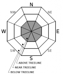
MODERATE danger exists above treeline on all aspects. New snow over the past 24 hours paired with strong and variable winds has formed fresh wind slabs in leeward terrain features, primarily above 9000ft. The avalanche danger near treeline and below treeline is LOW.


Avalanche Problem 1: Wind Slab
-
Character ?

-
Aspect/Elevation ?
-
Likelihood ?CertainVery LikelyLikelyPossible
 Unlikely
 -
Size ?HistoricVery LargeLargeSmall

Several inches of new snow and strong and variable winds may have formed isolated wind slabs in leeward terrain above treeline, primarily above 9000ft. Winds have blown out of the SE-S-SW-W-NW over the past 24 hours, and all aspects above treeline should be evaluated for the presence of fresh wind slabs. Watch for blowing snow, and monitor changing snow surface conditions if you venture into alpine terrain. The firm and icy old snow surface may act as a productive bed surface for the new snow to slide. Avoid slopes 35 degrees and steeper where areas of loaded snow exist.
Recent Observations
The Old Ski Bowl weather station recorded 1.26 inches of water and 2.5 inches of wet snow over the past 24 hours. Near and below the 6000ft level, steady rain fell yesterday afternoon and evening, and snow depths at the Castle Lake and Mount Eddy weather stations reduced by 4-5 inches. Freezing levels yesterday and overnight ranged from 7500-9000ft. Low visibility has limited observations from upper elevation terrain. The recent stormy pattern has created variable snow surfaces. Unconsolodated, wet and sloppy snow exists at and below 6000ft. Supportable melt-freeze crusts and rain glazes capping a moist upper snowpack can be found below treeline and near treeline. Above treeline, a transition from wet heavy snow to dry snow resting on a firm, icy old snow surface exists.
Weather and Current Conditions
Weather Summary
Expect an active weather pattern to continue throughout the week. Scattered showers will bring rain and snow today as a warm front passes through the advisory area. We will receive a quarter of an inch of water by the afternoon with freezing levels near 7500ft. A low-pressure system will develop off the San Francisco Bay tonight and tomorrow. This system will move to the north bringing cold air and more precipitation. Monday night through Tuesday, freezing levels will drop to 5000ft.
===========================================================
In Mt Shasta City at 0500, we have a current temperature of 48 F.
On Mt Shasta (South Side) in the last 24 hours...
Sand Flat - 6750 ft, the current temperture is 34 degrees F. Temperatures have ranged from 32 F to 38 F. Snow on the ground totals 98 inches with no new snow and 1 inch of settlement.
Old Ski Bowl - 7,600ft. the current temperature is 33 degrees F. Temperatures have ranged from 31 F to 36 F. Snow on the ground totals 175 inches with 2.5 inches of new snow and 1.39 inches of snow water equivalent.
Gray Butte - 8,000 feet, the current temperature is 32 degrees F. Temperatures have ranged from 31 F to 35 F. Winds have averaged 15-20 mph with gusts to 42 mph, blowing out of the west/southwest.
Mt Eddy Range (West side of Interstate-5)...
Castle Lake - 5,800 feet, the current temperature is 37 degrees F. Temperatures have ranged from 36 F to 39 F. Snow on the ground totals 94 inches with no new snow and 4 inches of settlement due to rain on snow.
Mt Eddy - 6,500 feet, the current temperature is 36 degrees F. Temperatures have ranged from 34 F to 39 F. Snow on the ground measures 85 inches with no new snow and 5 inches of settlement due to rain on snow. Winds have averaged 1-3 mph with gusts to 18 mph, south/southeast.
THIS SEASON PRECIPITATION for MT SHASTA CITY: Since October 1st (the wet season), we have received 44.89 inches of water, normal is 33.55 inches, putting us at 134% of normal. For the month of March, we have received 1.58 inches of water, normal is 4.05 inches, which is 39% of normal. And finally for the year of 2017, we received 23.73 inches of water, normal is 18.34 inches, putting us at 129% of normal.
Always check the weather before you attempt to climb Mt Shasta. Further, monitor the weather as you climb. Becoming caught on the mountain in any type of weather can compromise life and limb. Be prepared.
| 0600 temperature: | 37 |
| Max. temperature in the last 24 hours: | 38 |
| Average wind direction during the last 24 hours: | Southwest |
| Average wind speed during the last 24 hours: | 10-15 mi/hr |
| Maximum wind gust in the last 24 hours: | 20 mi/hr |
| New snowfall in the last 24 hours: | 1.9" - RAIN inches |
| Total snow depth: | 98 (-1) inches |
Two Day Mountain Weather Forecast
Produced in partnership with the Medford NWS
| For 7000 ft to 9000 ft | |||
|---|---|---|---|
|
Sunday (4 a.m. to 10 p.m.) |
Sunday Night (10 p.m. to 4 a.m.) |
Monday (4 a.m. to 10 p.m.) |
|
| Weather | Showers then scattered showers. Chance of precipitation 80% reducing to 50% by the afternoon. | Rain showers likely. Chance of precipitation 70%. | Rain and snow showers. Breezy. Chance of precipitation is 100%. |
| Temperature (°F) | 44 | 33 | 40 |
| Wind (mi/hr) | South/Southeast 11-15 mph | South/Southeast 14-21 mph | South 20-28 mph |
| Precipitation SWE / Snowfall (in) | / 0-.25 | / .25-.5 | / 0-.5 |
| For 9000 ft to 11000 ft | |||
| Sunday | Sunday Night | Monday | |
| Weather | Windy. Snow showers then scattered showers. Chance of precipitation 80% reducing to 40% by the afternoon. | Snow showers likely and windy. Chance of precipitation is 60%. | Snow showers and windy. Chance of precipitation is 90%. |
| Temperature (°F) | 25 | 22 | 25 |
| Wind (mi/hr) | Southwest 42-47 mph | South/Southwest 2-4 | South/Southwest 40-45 mph |
| Precipitation SWE / Snowfall (in) | / 2-4 | / 2-4 | / 4-8 |

