

You are here
Avalanche Advisory for 2017-03-23 06:45:35
- EXPIRED ON March 24, 2017 @ 6:45 amPublished on March 23, 2017 @ 6:45 am
- Issued by Aaron Beverly - Mount Shasta Avalanche Center
Bottom Line
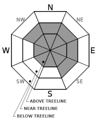
Avalanche danger is CONSIDERABLE above treeline, MODERATE near treeline, and LOW below treeline. Up to 17 inches of snow was received during the storms beginning on Monday afternoon. Above 8000' wind slabs exist and will continue to be loaded with blowing snow and new snow tonight. When venturing into terrain that is steeper than 30 degrees, pay attention. Avalanches are possible and likely on slopes covered with snow transported by the wind.


Avalanche Problem 1: Wind Slab
-
Character ?

-
Aspect/Elevation ?
-
Likelihood ?CertainVery LikelyLikelyPossible
 Unlikely
 -
Size ?HistoricVery LargeLargeSmall

With calm winds and freezing temperatures rising to over 8000' yesterday followed by a hard freeze last night, it is unlikely that any wind slab issue exists below tree line. Near treeline, isolated wind slabs may still exist on mostly northeast, east, and southeast aspects. With up to 17 inches of new snow received during the last series of storms, there is still plenty of snow available for transport at higher elevations. If you venture up into the alpine region, pay attention to where the wind is blowing snow. Leeward slopes will be sensitive to human triggered avalanches and natural avalanches may still be possible.
Up to 9 inches of snow is predicted to fall late tonight. This new snow combined with strong winds may create increasing wind slab avalanche danger by early tomorrow.
Forecast Discussion
Temperatures rose above freezing yesterday up to at least 8000' and then dipped down into the 20's overnight. No wind effect was observed at this elevation either. Avalanche danger is definitely decreasing at lower elevations but will remain heightened above treeline where plenty of snow remains available for transport. You may encounter zipper crusts below 8000' on all aspects today.
Tonight, more precipitation is expected in the form of snow above 5000'. This could increase the avalanche danger near treeline to CONSIDERABLE by early tomorrow morning if snow accumulation and winds verify.
Recent Observations
Tour of Grey Butte saw 9 to 11 inches of new snow since Monday. Above freezing temperatures up to at least 8000' were changing snow conditions on all aspects quickly. New snow was becoming heavy and sintered. Expect zipper crusts on Thursday.
Winds were calm and little sign of wind effect was observed below 8000'.
Small natural avalanches (D1) were seen on eastern aspects of Sun Bowl and Green Butte. Two were wind slab avalanches, one appeared to be a loose dry point release.
Test pit was dug on NE aspect of Grey Butte just below the weather station. Fist hard rain effected layer was discovered 48 cm down and 36 cm thick. Seemed very weak but no compression failures were seen here. Shovel shear test pulled ECT block out at this layer. Test results: CT13 @ 21 cm, ECTN18 @ 21 cm.
Skiing on west aspect in trees produced a lot of roller balls from the top 20 cm of snow. Skier reported skiing the chute just to the right of the trees on the west aspect below the weather station and saw no signs of instability.
See posted observation for pit profile.
Weather and Current Conditions
Weather Summary
Enjoy a short respite from wet weather today and then get ready for the another dose of winter as a warm front brings moist air into the region late this afternoon. Snow levels will drop from 4800' to 3900' tomorrow. Expect windy conditions to accompany up to a foot of new snow. A winter weather advisory is in effect from 11 p.m. tonight until 11 a.m. Friday. More unsettled weather will continue through Monday followed by a period of warmer dryer conditions ushering in a return to spring skiing.
===========================================================
In Mt Shasta City at 0500, we have a current temperature of 31 F.
On Mt Shasta (South Side) in the last 24 hours...
Sand Flat - 6,750 ft, the current temperture is 21 degrees F. Temperatures have ranged from 21 F to 37 F. Snow on the ground totals 108 inches with 2 inches of new snow and 2 inches of settlement.
Old Ski Bowl - 7,600ft. the current temperature is 17 degrees F. Temperatures have ranged from 17 F to 35 F. Snow on the ground totals 188 inches with 2 inches of new snow and 2 inches of settlement.
Gray Butte - 8,000 feet, the current temperature is 19 degrees F. Temperatures have ranged from 19 F to 33 F. Winds have averaged 9 mph with gusts to 35 mph, blowing predominantly from the west.
Mt Eddy Range (West side of Interstate-5)...
Castle Lake - 5,800 feet, the current temperature is 25 degrees F. Temperatures have ranged from 25 F to 33 F. Snow on the ground totals 94 inches with no new snow.
Mt Eddy - 6,500 feet, the current temperature is 19 degrees F. Temperatures have ranged from 19 F to 34 F. Snow on the ground measures 91 inches about 1/2 inche of new snow. Winds have been southerly averaging 2 mph with gusts up to 9 mph.
THIS SEASON PRECIPITATION for MT SHASTA CITY: Since October 1st (the wet season), we have received 47.31 inches of water, normal is 34.20 inches, putting us at 138% of normal. For the month of March, we have received 4.0 inches of water, normal is 4.70 inches, which is 85% of normal. And finally for the year of 2017, we received 26.15 inches of water, normal is 18.99 inches, putting us at 137% of normal.
Always check the weather before you attempt to climb Mt Shasta. Further, monitor the weather as you climb. Becoming caught on the mountain in any type of weather can compromise life and limb. Be prepared.
| 0600 temperature: | 21 |
| Max. temperature in the last 24 hours: | 37 |
| Average wind direction during the last 24 hours: | West |
| Average wind speed during the last 24 hours: | 9 mi/hr |
| Maximum wind gust in the last 24 hours: | 35 mi/hr |
| New snowfall in the last 24 hours: | 2 inches |
| Total snow depth: | 108 inches |
Two Day Mountain Weather Forecast
Produced in partnership with the Medford NWS
| For 7000 ft to 9000 ft | |||
|---|---|---|---|
|
Thursday (4 a.m. to 10 p.m.) |
Thursday Night (10 p.m. to 4 a.m.) |
Friday (4 a.m. to 10 p.m.) |
|
| Weather | Increasing clouds. | Snow. Breezy. Chance of precipitation is 100%. | Snow. The snow could be heavy at times. Chance of precipitation is 100%. |
| Temperature (°F) | 40 | 30 | 37 |
| Wind (mi/hr) | South 5-10 mph | South 15-20 mph | South 15-20 mph |
| Precipitation SWE / Snowfall (in) | / 0 | / 5-9 | / 5-10 |
| For 9000 ft to 11000 ft | |||
| Thursday | Thursday Night | Friday | |
| Weather | Increasing clouds. Windy. | Snow. Windy. Chance of precipitation is 100%. | Snow. The snow could be heavy at times. Windy. Chance of precipitation is 100%. |
| Temperature (°F) | 24 | 23 | 23 |
| Wind (mi/hr) | Southwest 15-20 mph | Southwest 0 | Southwest 45-50 mph |
| Precipitation SWE / Snowfall (in) | / 0 | / 6-10 | / 10-16 |

