

You are here
Avalanche Advisory for 2017-04-07 06:33:47
- EXPIRED ON April 8, 2017 @ 6:33 amPublished on April 7, 2017 @ 6:33 am
- Issued by Aaron Beverly - Mount Shasta Avalanche Center
Bottom Line
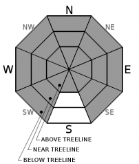
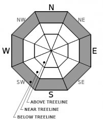
Avalanche danger near and above treeline is HIGH. HIGH means natural and human triggered avalanches are likely. The primary concern is wind slabs on leeward facing slopes. A secondary concern is storm slabs below treeline. Traveling on or near slopes greater than 30 degrees is not recommended. Avalanche danger below treeline is MODERATE.


Avalanche Problem 1: Wind Slab
-
Character ?

-
Aspect/Elevation ?
-
Likelihood ?CertainVery LikelyLikelyPossible
 Unlikely
 -
Size ?HistoricVery LargeLargeSmall

25 inches of snow has fallen and up to 3 feet more could be received by tomorrow. This coupled with strong southerly winds, will cause winds slabs to form and grow. Slabs could reach several feet in thickness. Winds since Wednesday night have ranged from the southwest, south, southeast. Today, winds will continue to be southerly and will then switch to westerly by tomorrow.
Look for slabs to form on leeward aspects. Slabs may exist on west, northwest, north, northeast, and east slopes near treeline. Above treeline, look for slabs on all aspects. Isolated slabs may exist below treeline near terrain exposed to the wind.
Mountain winds can be variable, so always pay attention to where the wind is blowing snow. Avoid wind loaded slopes greater than 35 degrees
Avalanche Problem 2: Storm Slab
-
Character ?

-
Aspect/Elevation ?
-
Likelihood ?CertainVery LikelyLikelyPossible
Unlikely
-
Size ?HistoricVery LargeLargeSmall
There wasn't much evidence of a storm slab problem yesterday, but we have received another 12 inches of snow since then and have plenty more on the way today.
A storm slab is a soft cohesive layer of new snow that breaks within the storm snow or on the old snow surface. Look for storm slabs in sheltered areas below treeline on all aspects greater than 30 degrees. Shooting cracks in the snow can be an indicator of this avalanche problem.
Forecast Discussion
Storm totals have reached 25 inches since late Wednesday night. Twelve inches was received last night. Forecasts are showing anywhere from 14 to 40 inches of new snow by tomorrow. These numbers all indicate a major red flag for avalanches. The snowpack will need time to adjust to the weight of the new snow.
Strong winds are predicted for today. This is another red flag. Wind slabs were observed yesterday near treeline and wind transport of snow was observed near and below treeline. Wind slabs will conitinue to grow today. They may reach several feet in thickness.
If you venture out in the backcountry today, give slopes greater than 30 degrees a wide berth. Don't be caught on or below them.
Avalanche danger below treeline is MODERATE due to storm slabs and isolated wind slabs. Remember MODERATE means human triggered avalanches are possible and natural avalanches are unlikely. Unlikely does not mean impossible! As always, choose your routes wisely when traveling in the backcountry today.
Recent Observations
Powder skis were a necessity yesterday and even then conditions felt deep!
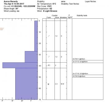
New snow yesterday morning at and above Bunny Flat ranged from 10 to 15 inches. Snow was heavy and slightly moist near the parking lot but transitioned to light and dry above 7500'. Ski penetration reached the depth of the old snow interface, a melt-freeze crust.
Wind was moderate to strong, blowing from the east to southeast and loading was observed on southwest and west aspects. Windslabs on small rollovers were reactive to ski cuts, but did not propagate beyond the length of the ski.
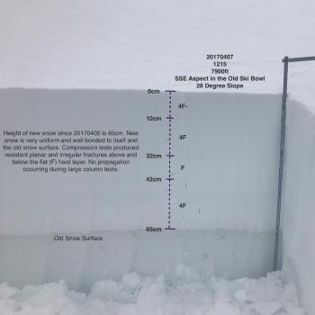
New snow was bonding well to the old snow interface. Compression tests produced resistant planar failures at and below the old snow/new snow interface that were not significant concerns. No propagation was seen in large column tests. See posted observation for more details.
Total snow accumulation since Wednesday night is 25 inches. Overnight snow totaled 12 inches. Winds have ranged from southwest, south, and south southeast. Snow levels have been near 4500' and lower.
Weather and Current Conditions
Weather Summary
The system that came through starting at 11 p.m. Wednesday night brought much more snow accumulation than models predicted, reaching an overnight total of 10 inches. Accumulations Thursday and Thursday night were as expected. So far we have received nearly 25 inches.
A winter storm warning has been extended to Friday at 5 P.M. as the storm that began last night continues to produce more snow and high winds. Conservative estimates predict up to 14 more inches by tomorrow afternoon before this system moves on. Others are showing 27-40 inches. Snow levels are expected to be 3900' today and will lower tomorrow.
We will get a short break Sunday and then expect continued unsettled weather throughout next week starting Monday.
------------------------------------------------------------------------------
In Mt Shasta City at 0500, we have a current temperature of 39 F
On Mt Shasta (South Side) in the last 24 hours...
Sand Flat - 6,750 ft. The current temperature is 29 degrees F. Temperatures have ranged from 28 F to 33 F. Snow on the ground totals 124 inches with 15 inches of new.
Old Ski Bowl - 7,600ft. The current temperature is 25 degrees F. Temperatures have ranged from 25 F to 31 F. Snow on the ground totals 206 inches with 14 inches of new snow.
Grey Butte - 8,000 feet. The current temperature is 25 degrees F. Temperatures have ranged from 25 F to 31 F. Winds have averaged 15 mph with gusts to 49 mph, blowing mostly from the south southeast.
Mt Eddy Range (West side of Interstate-5)...
Castle Lake - 5,800 feet. The current temperature is 29 degrees F. Temperatures have ranged from 29 F to 32 F. Snow on the ground totals 113 inches with about 16 inches of new.
Mt Eddy - 6,500 feet, the current temperature 27 degrees F. Temperatures have ranged from 27 F to 31 F. Snow on the ground measures 107 inches with 11 inches of new. Winds have averaged 4 mph out of the southwest with gusts up to 28 mph.
THIS SEASON PRECIPITATION for MT SHASTA CITY: Since October 1st (the wet season), we have received 52.97 inches of water, normal is 36.16 inches, putting us at 146% of normal. For the month of April, we have received 3.51 inches of water, normal is .70 inches, which is 501% of normal. And finally for the year of 2017, we received 31.81 inches of water, normal is 20.95 inches, putting us at 152% of normal.
Always check the weather before you attempt to climb Mt Shasta. Further, monitor the weather as you climb. Becoming caught on the mountain in any type of weather can compromise life and limb. Be prepared.
| 0600 temperature: | 29 |
| Max. temperature in the last 24 hours: | 33 |
| Average wind direction during the last 24 hours: | South southeast |
| Average wind speed during the last 24 hours: | 15 mi/hr |
| Maximum wind gust in the last 24 hours: | 49 mi/hr |
| New snowfall in the last 24 hours: | 15 inches |
| Total snow depth: | 124 inches |
Two Day Mountain Weather Forecast
Produced in partnership with the Medford NWS
| For 7000 ft to 9000 ft | |||
|---|---|---|---|
|
Friday (4 a.m. to 10 p.m.) |
Friday Night (10 p.m. to 4 a.m.) |
Saturday (4 a.m. to 10 p.m.) |
|
| Weather | Snow before 11am, then snow showers after 11am. The snow could be heavy at times. Some thunder is also possible. Windy. Chance of precipitation is 100%. | Snow showers. The snow could be heavy at times. Chance of precipitation is 100%. | Snow showers. Some thunder is also possible. Chance of precipitation is 100%. |
| Temperature (°F) | 34 | 20 | 35 |
| Wind (mi/hr) | South 25-40 mph, gusts up to 70 | South then west 10-20 mph | West 10-15 mph |
| Precipitation SWE / Snowfall (in) | / 15-20 | / 10-16 | / 2-4 |
| For 9000 ft to 11000 ft | |||
| Friday | Friday Night | Saturday | |
| Weather | Snow before 11am, then snow showers after 11am. The snow could be heavy at times. Some thunder is also possible. Windy. Chance of precipitation is 100%. | Snow showers. The snow could be heavy at times. Windy. Chance of precipitation is 100%. | Snow showers. Some thunder is also possible. Windy. Chance of precipitation is 100%. |
| Temperature (°F) | 13 | 5 | 7 |
| Wind (mi/hr) | Southwest 60 mph | Southwest 15-20 | West 31 mph |
| Precipitation SWE / Snowfall (in) | / 15-20 | / 10-16 | / 2-4 |

