

You are here
Avalanche Advisory for 2017-04-08 06:56:49
- EXPIRED ON April 9, 2017 @ 6:56 amPublished on April 8, 2017 @ 6:56 am
- Issued by Andrew Kiefer - Mt Shasta Avalanche Center
Bottom Line
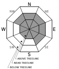
CONSIDERABLE avalanche danger exists above treeline and near treeline. Wind slab avalanches are the primary concern. Natural avalanches are possible and human triggered avalanches are likely on wind loaded slopes 35 degrees and steeper. The avalanche danger is MODERATE below treeline. A storm slab avalanche problem is an additional concern today as the snowpack adjusts to the weight of the recent snow.


Avalanche Problem 1: Wind Slab
-
Character ?

-
Aspect/Elevation ?
-
Likelihood ?CertainVery LikelyLikelyPossible
 Unlikely
 -
Size ?HistoricVery LargeLargeSmall

More than 2 feet of new snow paired with strong westerly winds have created fresh winds slabs near and above treeline. The potential for wind slabs exists on all aspects above treeline and on NW-N-NE-E-SE aspects near treeline. Wind slabs are several feet thick, and if triggered, could produce an avalanche large enough to bury, injure, or kill a person. Wind slabs will continue to grow in size as steady westerly winds blow today. Avoid slopes 35 degrees and steeper where evidence of the wind slab problem exists. Look for blowing snow, cornices, and textured snow surfaces as good indicators that wind loading has occurred. Unsupported slopes, convex rollovers, and slopes just below ridgelines are where the wind slab problem is most likely to be triggered.
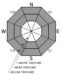
Avalanche Problem 2: Storm Slab
-
Character ?

-
Aspect/Elevation ?
-
Likelihood ?CertainVery LikelyLikelyPossible
Unlikely
-
Size ?HistoricVery LargeLargeSmall
Storm slabs may be a concern today on all aspects near and below treeline. Natural storm slab avalanches are unlikely, while human triggering remains possible. Recent observations indicate that the new snow has bonded well to the old snow surface and to itself, and the storm slab problem will be stubborn to trigger today. Make sure to dig down to assess the new layers of snow before venturing into steeper terrain.
Forecast Discussion
Winter has certainly returned to Mount Shasta. Two feet of cold new snow and strong winds have made for increased avalanche hazard throughout the advisory area. Light snowfall will continue throughout the day, but the brunt of this storm has come and gone. Tomorrow should be clear and dry for most of the day before another round of snowfall begins late in the evening. The wind slab problem is the greatest concern for backcountry travelers. Winds will continue to transport snow and create fresh wind slabs for the next several days. Storm slabs are a secondary avalanche concern for today. The snowpack will need some time to adjust to the weight of the new snow before stability improves.
The Everitt Memorial Highway has been plowed all the way to Bunny Flat, and the road is open. The Castle Lake Road has not been plowed.
Our last avalanche advisory of the season will be Sunday, April 16th.
Recent Observations
Our storm total since late Wednesday night is 24-30 inches above the 6000ft level. Snowfall diminished throughout the day yesterday, but most of our remote weather stations picked up another 2-3 inches of snow overnight. Westerly winds have been strong and gusty for the past 3 days, and have significantly affected the distribution of the new snow. Winds slabs several feet thick were observed near and above treeline. Above 8000ft, several exposed terrain features were scoured to the ground yesterday on Mount Shasta, despite all the new snow.
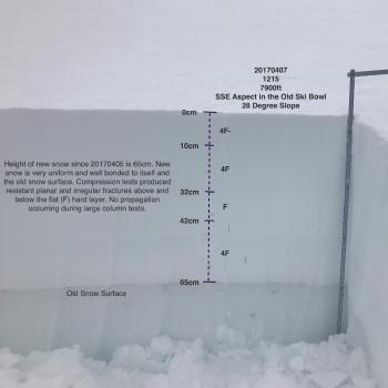
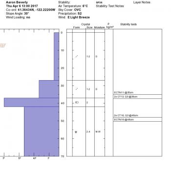
Visibility was poor throughout the day yesterday, and snowfall was light and intermittent between 10am and 2pm during a ride from Sand Flat to 8000ft in the Old Ski Bowl. Despite the rapid load of new snow and strong winds, no avalanches, shooting cracks, or whumphing were observed. The new snow has bonded very well to the old snow surface and to itself. Despite several density breaks within the new snow, no significantly concerning results were found during stability tests conducted yesterday below treeline. Compression tests produced resistant planar fractures on the interface between Thursday’s snow and Friday’s snow about 1ft below the snow surface. No propagation occurred in extended column tests. See Observations below for more information.
Weather and Current Conditions
Weather Summary
A trough of low pressure looks to exit the region by tomorrow, and will bring lingering snow showers to the advisory area today. The remainder of the weekend looks to be unseasonably cold, with freezing levels staying below 4000ft, and overnight lows in the teens near and below treeline. Westerly winds will continue, and look to create challenging gusty conditions in the alpine. The majority of the advisory area may pick up 1-3 inches of snow today. There is also a slight chance of thunderstorms this afternoon. A period of high pressure is expected tomorrow, bringing clearing skies and sunshine. The dry weather window will be short lived, as another round of snowfall will begin late Sunday night.
------------------------------------------------------------------------------
In Mt Shasta City at 0500, we have a current temperature of 32 degrees F.
On Mt Shasta (South Side) in the last 24 hours...
Sand Flat - 6,750 ft. The current temperature is 19 degrees F. Temperatures have ranged from 19 F to 33 F. Snow on the ground totals 124 inches with 2 inches of new snow and 3 inches of settlement.
Old Ski Bowl - 7,600ft. The current temperature is 13 degrees F. Temperatures have ranged from 13 F to 31 F. Snow on the ground totals 209 inches with 3 inches of new snow and 2 inches of settlement.
Grey Butte - 8,000 feet. The current temperature is 13 degrees F. Temperatures have ranged from 13 F to 25 F. Winds have averaged 20-30 mph with gusts to 64 mph, blowing from the SW, W, and NW.
Mt Eddy Range (West side of Interstate-5)...
Castle Lake - 5,800 feet. The current temperature is 19 degrees F. Temperatures have ranged from 19 F to 32 F. Snow on the ground totals 113 inches with 2 inches of new snow and 2 inches of settlement.
Mt Eddy - 6,500 feet, the current temperature 16 degrees F. Temperatures have ranged from 15 F to 29 F. Snow on the ground measures 108 inches with 2 inches of new snow and 1 inch of settlement. Winds have averaged 1-4 mph with gusts up to 22 mph out of the SE, S, and SW.
THIS SEASON PRECIPITATION for MT SHASTA CITY: Since October 1st (the wet season), we have received 53.24 inches of water, normal is 36.27 inches, putting us at 147% of normal. For the month of April, we have received 3.78 inches of water, normal is .81 inches, which is 466% of normal. And finally for the year of 2017, we received 32.08 inches of water, normal is 21.06 inches, putting us at 152% of normal.
Always check the weather before you attempt to climb Mt Shasta. Further, monitor the weather as you climb. Becoming caught on the mountain in any type of weather can compromise life and limb. Be prepared.
| 0600 temperature: | 19 |
| Max. temperature in the last 24 hours: | 33 |
| Average wind direction during the last 24 hours: | SW, W, NW |
| Average wind speed during the last 24 hours: | 10-15 mi/hr |
| Maximum wind gust in the last 24 hours: | 30 mi/hr |
| New snowfall in the last 24 hours: | 2 inches |
| Total snow depth: | 124 inches |
Two Day Mountain Weather Forecast
Produced in partnership with the Medford NWS
| For 7000 ft to 9000 ft | |||
|---|---|---|---|
|
Saturday (4 a.m. to 10 p.m.) |
Saturday Night (10 p.m. to 4 a.m.) |
Sunday (4 a.m. to 10 p.m.) |
|
| Weather | Snow showers. Some thunder is also possible. Chance of precipitation 80%. | Chance of snow showers. Cloudy. Chance of precipitation 40%. | Partly Sunny |
| Temperature (°F) | 30 | 17 | 30 |
| Wind (mi/hr) | northwest 8-10 mph | west becoming south 5-10 mph | south 10-17 mph, gusting 26 mph |
| Precipitation SWE / Snowfall (in) | / 2-4 | / 0-1 | / 0 |
| For 9000 ft to 11000 ft | |||
| Saturday | Saturday Night | Sunday | |
| Weather | Snow showers and windy. Some thunder is also possible. Wind chill values as low as -18 F. Chance of precipitation 80%. | A 50% chance of snow showers before 11pm. Mostly cloudy with wind chill values as low as -18 F. Windy. | Windy with partly sunny skies. Wind chill values as low as -15 F. |
| Temperature (°F) | 8 | 8 | 13 |
| Wind (mi/hr) | west 33-43 mph, gusting to 65 mph | southwest 3-5 | southwest 36-44 mph, gusting to 65 mph |
| Precipitation SWE / Snowfall (in) | / 3-5 | / 0-1 | / 0 |

