

You are here
Avalanche Advisory for 2017-04-10 06:51:36
- EXPIRED ON April 11, 2017 @ 6:51 amPublished on April 10, 2017 @ 6:51 am
- Issued by Andrew Kiefer - Mt Shasta Avalanche Center
Bottom Line
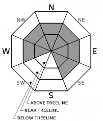
The avalanche danger is MODERATE near and above treeline. Human triggered wind slab avalanches are possible. New snow and southwesterly winds continue to form shallow wind slabs on NW-N-NE-E-SE aspects near and above treeline. Natural avalanches are unlikely. LOW avalanche danger exists below treeline.


Avalanche Problem 1: Wind Slab
-
Character ?

-
Aspect/Elevation ?
-
Likelihood ?CertainVery LikelyLikelyPossible
 Unlikely
 -
Size ?HistoricVery LargeLargeSmall

Human triggered wind slab avalanches remain possible on W-NW-N-NE-E-SE aspects near and above treeline. Natural wind slab avalanches are unlikely today, and any wind slab avalanche would likely be small. Snow is still available for transport, and westerly and southerly winds are creating shallow, fresh wind slabs. Wind slabs will most likely be triggered on leeward slopes 35 degrees and steeper that are unsupported, have a convex shape, or that are just below ridgelines.
Forecast Discussion
Overall, snowpack stability is good throughout the advisory area. Isolated pockets of fresh wind slab do continue to pose a hazard for backcountry travelers. Be sure to identify features of concern, and avoid steep wind loaded slopes, especially those with high consequence run-outs. Another significant winter storm is set for later in the week. Southerly winds will be steadily ramping up tomorrow, and heavy precipitation is expected by Wednesday night.
We will issue our last avalanche advisory of the season this Sunday, April 16th.
Recent Observations
The advisory area picked up 2-3 inches of snow over the past 24 hours and temperatures remained below freezing 6000ft and above. Skies were mostly cloudy throughout the day yesterday, with brief periods of sunshine. Winds have been blowing out of the west and south over the past several days. Wind speeds yesterday were light to moderate.
The recent storm snow settled several inches over the weekend, and overall, stability is improving. Snow is available for transport, and any snowpack instability is associated with fresh wind-loaded snow. The only avalanche observed or reported in the past several days occurred naturally on the northwest side of Green Butte Ridge on Friday. Southerly winds loaded this slope, which extends down into Avalanche Gulch. The avalanche had impressive propagation, but only ran a short distance and had a maximum crown height of 1ft.
Weather and Current Conditions
Weather Summary
Today will bring mostly cloudy skies with scattered snow showers in the morning. Little to no snow accumulation is expected. Conditions look to dry out by the afternoon, and the cloud cover will gradually break down throughout the day. High temperatures at the 6000ft level will reach the upper 30’s F. The dry and clear weather window will be short lived, as a strong low-pressure system will move into the area by tomorrow afternoon. This system looks to bring plenty of precipitation as well as gusty southerly winds. Winter will continue throughout the week with significant snowfall on Wednesday night and Thursday.
--------------------------------------------------------------------------------
In Mt Shasta City at 0500, we have a current temperature of 36 F
On Mt Shasta (South Side) in the last 24 hours...
Sand Flat - 6,750 ft. The current temperature is 27 degrees F. Temperatures have ranged from 27 F to 33 F. Snow on the ground totals 122 inches with 2 inches of new snow, and 1 inch of settlement.
Old Ski Bowl - 7,600ft. The current temperature is 23 degrees F. Temperatures have ranged from 13 F to 32 F. Snow on the ground totals 207 inches with 3 inches of new snow and 2 inches of settlement.
Grey Butte - 8,000 feet. The current temperature is 22 degrees F. Temperatures have ranged from 15 F to 28 F. Winds have averaged 10-20 mph with gusts to 28 mph, blowing primarily from the west/southwest.
Mt Eddy Range (West side of Interstate-5)...
Castle Lake - 5,800 feet. The current temperature is 28 degrees F. Temperatures have ranged from 22 F to 39 F. Snow on the ground totals 111 inches with 2 inches of new snow and 2 inches of settlement.
Mt Eddy - 6,500 feet, the current temperature 24 degrees F. Temperatures have ranged from 15 F to 30 F. Snow on the ground measures 105 inches with 2 inches of new snow and 1 inch of settlement. Winds have averaged 1-3 mph with gusts to 21 mph blowing out of the south/southeast.
THIS SEASON PRECIPITATION for MT SHASTA CITY: Since October 1st (the wet season), we have received 53.42 inches of water, normal is 36.47 inches, putting us at 146% of normal. For the month of April, we have received 3.96 inches of water, normal is 1.01 inches, which is 392% of normal. And finally for the year of 2017, we received 32.26 inches of water, normal is 21.26 inches, putting us at 152% of normal.
Always check the weather before you attempt to climb Mt Shasta. Further, monitor the weather as you climb. Becoming caught on the mountain in any type of weather can compromise life and limb. Be prepared.
| 0600 temperature: | 27 |
| Max. temperature in the last 24 hours: | 33 |
| Average wind direction during the last 24 hours: | west |
| Average wind speed during the last 24 hours: | 10-15 mi/hr |
| Maximum wind gust in the last 24 hours: | 20 mi/hr |
| New snowfall in the last 24 hours: | 2 inches |
| Total snow depth: | 122 inches |
Two Day Mountain Weather Forecast
Produced in partnership with the Medford NWS
| For 7000 ft to 9000 ft | |||
|---|---|---|---|
|
Monday (4 a.m. to 10 p.m.) |
Monday Night (10 p.m. to 4 a.m.) |
Tuesday (4 a.m. to 10 p.m.) |
|
| Weather | Scattered snow showers mainly before 11am. Mostly sunny. Chance of precipitation 30%. | Mostly Cloudy | An 80% chance of snow showers. |
| Temperature (°F) | 35 | 25 | 37 |
| Wind (mi/hr) | south 12-17 mph | south/southwest 5-9 mph | south 13-21 mph |
| Precipitation SWE / Snowfall (in) | / 0-.5 | / 0 | / 2-4 |
| For 9000 ft to 11000 ft | |||
| Monday | Monday Night | Tuesday | |
| Weather | Scattered snow showers, mainly before 11am. Windy. Wind chill values as low as -14 F. Becoming mostly sunny in the afternoon. | Mostly cloudy and windy | Snow likely and windy. Chance of precipitation is 70%. |
| Temperature (°F) | 16 | 16 | 21 |
| Wind (mi/hr) | west/southwest 36-41 mph | south/southwest 0-.5 | south/southwest 40-50 mph, gusting to 80 mph |
| Precipitation SWE / Snowfall (in) | / 0-.5 | / 0 | / 3-5 |

