

You are here
Avalanche Advisory for 2017-04-11 06:43:00
- EXPIRED ON April 12, 2017 @ 6:43 amPublished on April 11, 2017 @ 6:43 am
- Issued by Andrew Kiefer - Mt Shasta Avalanche Center
Bottom Line
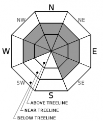
The avalanche danger is MODERATE near and above treeline. A potent winter storm will begin today bringing snowfall, gale force winds, and unseasonably cold temperatures. Wind slabs are the primary avalanche concern. Southerly winds continue to form wind slabs on W-NW-N-NE-E-SE aspects near and above treeline. Be sure to monitor conditions as they change, and anticipate increasing avalanche danger as the storm progresses over the next 24-48 hours. The avalanche danger is LOW below treeline.


Avalanche Problem 1: Wind Slab
-
Character ?

-
Aspect/Elevation ?
-
Likelihood ?CertainVery LikelyLikelyPossible
 Unlikely
 -
Size ?HistoricVery LargeLargeSmall

The wind slab problem will grow in distribution and size with the incoming snow and wind expected today through Thursday. Fresh winds slabs already exist near and above treeline on W-NW-N-NE-E-SE aspects, and will be become more sensitive to natural and human triggers as the storm progresses. Monitor conditions as they change today. Watch for blowing snow, cornice development, and textured snow surfaces to help identify the presence of wind slabs. Wind slabs will most likely be triggered on leeward slopes 35 degrees and steeper that are unsupported, have a convex shape, or that are just below ridgelines.
Forecast Discussion
Precipitation and wind will be the driving factors increasing the avalanche hazard. Strong southerly winds will ramp up today, and the advisory area looks to receive the bulk of the expected snowfall tomorrow and tomorrow night. Anticipate changing conditions today, and a transition to cold, wintery weather. If more snow accumulates today than expected, the avalanche danger may rise to CONSIDERABLE above treeline. Make sure to evaluate snow and terrain carefully, and adjust your plans accordingly.
We will issue our last avalanche advisory of the season this Sunday, April 16th.
Recent Observations
Just a trace of new snow was reported at our remote weather stations on the south side of Mount Shasta during the past 24 hours. Winds stayed calm to light near and below treeline yesterday, with moderate wind speeds in the alpine. Cloud cover burned off by late morning, and mostly clear skies prevailed. Snow surfaces stayed cold for most of the day, and the few inches of new snow made for good skiing. Hardly any wind transport was visible on Mount Shasta. No known wind slab avalanches have occurred since Friday. Snowpack stability was good overall yesterday. Snow surfaces handled the solar radiation well. Roller balling and wet loose activity was minimal, even though the surface snow became heavy by the end of the day.
Weather and Current Conditions
Weather Summary
A potent low-pressure system sitting off of the Pacific Northwest coast will begin to affect the advisory area today. This system will bring a cold air mass with it, along with very strong southerly winds. Winds speeds will steadily increase during the storm period, and gale force winds tomorrow will make for blizzard conditions. Precipitation should begin today with 4-6 inches of snow expected at the 6000ft level and above. Freezing levels will be near 4500ft today, and will drop to town level by Thursday. Heavy precipitation is expected tomorrow and Thursday, with Wednesday night looking like the peak of the storm.
--------------------------------------------------------------------------------
In Mt Shasta City at 0500, we have a current temperature of 39 F
On Mt Shasta (South Side) in the last 24 hours...
Sand Flat - 6,750 ft. The current temperature is 30 degrees F. Temperatures have ranged from 20 F to 34 F. Snow on the ground totals 119 inches with a trace of new snow, and 3 inches of settlement.
Old Ski Bowl - 7,600ft. The current temperature is 25 degrees F. Temperatures have ranged from 16 F to 37 F. Snow on the ground totals 204 inches with a trace of new snow and 3 inches of settlement.
Grey Butte - 8,000 feet. The current temperature is 23 degrees F. Temperatures have ranged from 17 F to 32 F. Winds have averaged 5-10 mph with gusts to 28 mph, blowing primarily from the south/southeast
Mt Eddy Range (West side of Interstate-5)...
Castle Lake - 5,800 feet. The current temperature is 30 degrees F. Temperatures have ranged from 23 F to 47 F. Snow on the ground totals 111 inches with no new snow and little settlement.
Mt Eddy - 6,500 feet, the current temperature 29 degrees F. Temperatures have ranged from 16 F to 36 F. Snow on the ground measures 102 inches with no new snow and 3 inches of settlement. Winds have averaged 1-3 mph with gusts to 8 mph blowing out of the south/southeast and south/southwest.
THIS SEASON PRECIPITATION for MT SHASTA CITY: Since October 1st (the wet season), we have received 53.44 inches of water, normal is 36.58 inches, putting us at 146% of normal. For the month of April, we have received 3.96 inches of water, normal is 1.12 inches, which is 355% of normal. And finally for the year of 2017, we received 32.28 inches of water, normal is 21.37 inches, putting us at 151% of normal.
Always check the weather before you attempt to climb Mt Shasta. Further, monitor the weather as you climb. Becoming caught on the mountain in any type of weather can compromise life and limb. Be prepared.
| 0600 temperature: | 30 |
| Max. temperature in the last 24 hours: | 34 |
| Average wind direction during the last 24 hours: | west |
| Average wind speed during the last 24 hours: | 5-10 mi/hr |
| Maximum wind gust in the last 24 hours: | 20 mi/hr |
| New snowfall in the last 24 hours: | 0 inches |
| Total snow depth: | 119 inches |
Two Day Mountain Weather Forecast
Produced in partnership with the Medford NWS
| For 7000 ft to 9000 ft | |||
|---|---|---|---|
|
Tuesday (4 a.m. to 10 p.m.) |
Tuesday Night (10 p.m. to 4 a.m.) |
Wednesday (4 a.m. to 10 p.m.) |
|
| Weather | Snow and breezy. Chance of precipitation is 100% | Snow and windy. Chance of precipitation is 90%. | Snow and breezy. Chance of precipitation is 100%. |
| Temperature (°F) | 36 | 30 | 35 |
| Wind (mi/hr) | south/southeast 20-25 mph, gusting to 38 | south 26-33 mph, gusting to 50 mph | south 23-29 mph, gusting to 43 mph |
| Precipitation SWE / Snowfall (in) | / 3-5 | / 4-8 | / 6-10 |
| For 9000 ft to 11000 ft | |||
| Tuesday | Tuesday Night | Wednesday | |
| Weather | Snow and windy. Wind chill values as low as -3 F. Chance of precipitation is 100%. | Snow and windy. Wind chill values as low as -8. Chance of precipitation is 90%. | Heavy snow and and windy. Wind chill values as low as -8 F. Chance of precipitation is 100%. |
| Temperature (°F) | 21 | 19 | 19 |
| Wind (mi/hr) | south/southwest 55-65 mph, gusting to 100 mph | south/southwest 6-10 | south 70-80 mph, gusting over 100 mph |
| Precipitation SWE / Snowfall (in) | / 6-10 | / 6-10 | / 12-18 |

