

You are here
Avalanche Advisory for 2017-12-10 06:52:29
- EXPIRED ON December 11, 2017 @ 6:52 amPublished on December 10, 2017 @ 6:52 am
- Issued by Andrew Kiefer - Mt Shasta Avalanche Center
Bottom Line
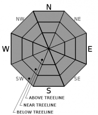
The avalanche danger is LOW at all elevations and on all aspects today. Both human triggered and natural avalanches are unlikely. Small wind slabs may exist in leeward terrain 10,000ft and higher on Mount Shasta. Very firm and icy snow surfaces can be found on the upper mountain as well. Arresting a fall in these conditions could be difficult.


Avalanche Problem 1: Normal Caution
-
Character ?

-
Aspect/Elevation ?
-
Likelihood ?CertainVery LikelyLikelyPossible
 Unlikely
 -
Size ?HistoricVery LargeLargeSmall

Natural and human triggered avalanches are unlikely and normal caution is advised. LOW danger does not mean the backcountry is free of hazard. Watch for isolated wind slabs on steep slopes in high elevation leeward terrain. The chances of hitting a season ending shallowly buried object are far more likely than triggering an avalanche. Also, very smooth and icy snow surfaces exist above treeline on Mount Shasta, and a slide for life could easily occur on the upper mountain in these conditions.
Forecast Discussion
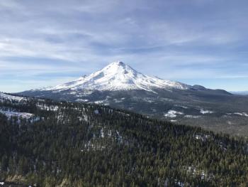
High pressure has now been over the advisory area for a full week. We have been experiencing mild temperatures, little wind, and plenty of sunshine in the mountains. These factors have contributed to consolidating and strengthening an already stable snowpack (where coverage exists) and making it feel quite a bit more like springtime than early December.
For the near future, the overall weather pattern and snowpack conditions look to stay the same. Even though LOW avalanche danger exists, be sure to take the appropriate precautions in the backcountry and always carry avalanche rescue gear. If you are venturing into high alpine terrain, be prepared for firm and icy conditions. The potential for falling rock and ice also exists, especially high in Avalanche Gulch, and a helmet, crampons, and an ice axe are critical tools to bring and to know how to use.
Recent Observations
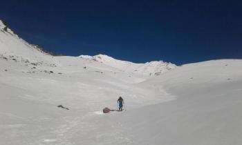
Warm and dry conditions have been the story recently. Strong temperature inversions continue with overnight lows remaining above freezing at the 8,000ft level. A variety of snow surface conditions can be found in areas 6500-7000ft and higher where a useable snowpack exists within our advisory area:
*Firm, icy and bombproof old snow
*Corn snow on southerly slopes unaffected by wind
*Cold and dry snow on shady slopes near and below treeline
*Wind slab "scabs", small with random distribution
*Low snow coverage with many shallowly buried obstacles
During an outing in the Ash Creek Butte area yesterday, it was possible to ride snowmobiles on roads beginning as low as 5500ft. Snow coverage near and below treeline on the east side ranges from 1-2ft with a significant change in snow height around the 6000ft level. Snow surfaces were surprisingly supportable, and in many shaded areas they have remained cold and dry.

Weather and Current Conditions
Weather Summary
Persistence has been a good forecast for the past few days with high pressure in control and very little day-to-day change. This will remain the case well into next week as the upper level ridge remains firmly in place over the western U.S. Freezing levels will rise to almost 12,000ft on Mount Shasta today with continuing easterly flow and light winds. High temperatures for the day will be near 50 degrees at the 6,000ft level. Strong temperature inversions will continue with nighttime lows significantly colder in the valleys than at higher elevations in the mountains.
-----------------------------------------------------------
THIS SEASON PRECIPITATION for MT SHASTA CITY: Since October 1st (the wet season), we have received 5.72 inches of water, normal is 9.45 inches, putting us at 61% of normal. For the month of December, we have received .18 inches of water, normal is 2.09 inches, which is 9% of normal. And finally for the year of 2017, we received 44.71 inches of water, normal is 37.45 inches, putting us at 120% of normal.
Always check the weather before you attempt to climb Mt Shasta. Further, monitor the weather as you climb. Becoming caught on the mountain in any type of weather can compromise life and limb. Be prepared.
24 Hour Weather Station Data @
| Weather Station | Temp (°F) | Wind (mi/hr) | Snow (in) | Comments | ||||||||
|---|---|---|---|---|---|---|---|---|---|---|---|---|
| Cur | Min | Max | Avg | Avg | Max Gust | Dir | Depth | New | Water Equivalent | Settlement | ||
| Mt. Shasta City (3540 ft) | 27 | 26 | 52 | 35 | 3 | NNE | ||||||
| Sand Flat (6750 ft) | 32 | 32 | 52 | 37 | 14 | 0 | 0 | |||||
| Ski Bowl (7600 ft) | 47 | 43 | 50 | 46 | 18 | 0 | 0 | |||||
| Gray Butte (8000 ft) | 48 | 45 | 53 | 48 | 11 | 30 | E | |||||
| Castle Lake (5870 ft) | 44 | 42 | 50 | 45 | 0 | 0 | ||||||
| Mount Eddy (6509 ft) | 37 | 37 | 52 | 41 | 3 | 6 | WSW | 11 | 0 | |||
| Ash Creek Bowl (7250 ft) | Station Down | |||||||||||
| Ash Creek Ridge (7895 ft) | Station Down |
Two Day Mountain Weather Forecast
Produced in partnership with the Medford NWS
| For 7000 ft to 9000 ft | |||
|---|---|---|---|
|
Sunday (4 a.m. to 10 p.m.) |
Sunday Night (10 p.m. to 4 a.m.) |
Monday (4 a.m. to 10 p.m.) |
|
| Weather | Sunny | Clear | Sunny |
| Temperature (°F) | 53 | 38 | 52 |
| Wind (mi/hr) | East/Southeast 3-7 | East/Southeast 9 | Southeast 8 |
| Precipitation SWE / Snowfall (in) | / 0 | / 0 | / 0 |
| For 9000 ft to 11000 ft | |||
| Sunday | Sunday Night | Monday | |
| Weather | Sunny | Clear and Breezy | Sunny and Breezy |
| Temperature (°F) | 40 | 36 | 36 |
| Wind (mi/hr) | Southeast 5-10 mph, gusting 25 mph | South 0 | South/Southwest 24-26 mph, gusting 40 mph |
| Precipitation SWE / Snowfall (in) | / 0 | / 0 | / 0 |

