

You are here
Avalanche Advisory for 2017-12-11 06:40:09
- EXPIRED ON December 12, 2017 @ 6:40 amPublished on December 11, 2017 @ 6:40 am
- Issued by Andrew Kiefer - Mt Shasta Avalanche Center
Bottom Line
LOW avalanche danger exists throughout the advisory area. Natural and human triggered avalanches are unlikely. Normal caution is advised. Very firm and icy snow surfaces can be found above treeline on Mount Shasta. Arresting a fall in these conditions could be difficult.


Avalanche Problem 1: Normal Caution
-
Character ?

-
Aspect/Elevation ?
-
Likelihood ?CertainVery LikelyLikelyPossible
 Unlikely
 -
Size ?HistoricVery LargeLargeSmall

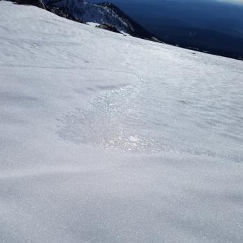
Triggering an avalanche is unlikely today. Wind slabs in steep leeward terrain above 10,000ft may still exist, but are very isolated in their distribution and are stubborn/unreactive to triggers at this point. The chances of hitting a shallowly buried object and getting injured are far more likely than triggering and getting caught in an avalanche. Also, very smooth and icy snow surfaces exist above treeline on Mount Shasta, and a slide for life could easily occur on the upper mountain in these conditions.
Forecast Discussion
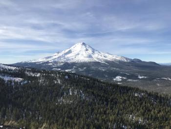
Our existing snowpack in terrain 6,500-7,000ft and up has only settled a few inches during the recent warm and dry spell. The short winter days, low angle of the sun, and clear and somewhat cooler nights have allowed our vulnerable and thin snowpack to hang in there. Overall, snowpack stability is good, and LOW avalanche danger with little change is expected until we get more snow. Conditions are certainly variable though, and our snowpack needs to grow in order to adequately cover up the ground and bring all of our advisory area into play for winter recreation.
Recent Observations
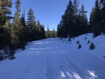
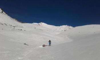
7,000ft and higher on Mount Shasta continues to be best place to recreate on snow at this time. Variable snow surfaces can be found:
*Firm and icy old snow
*Corn snow on southerly slopes unaffected by wind
*Cold and dry snow on shady slopes near and below treeline
*Small wind slabs: very stubborn to trigger and isolated in distribution
*Low snow coverage with many shallowly buried obstacles
With careful route selection, it is possible to ski and ride on the east side of the advisory area near Ash Creek Butte. In areas 6,000ft and up, 1-2ft of snow coverage exists. It was possible to drive to 6,4000ft up Parks Creek road yesterday and within about 1.5 miles of the pass. Very patchy and thin snow cover exists in the Mount Eddy area. On northerly aspects above 6,000ft, 1-1.5ft of snow was observed. Many slopes however are not holding any snow. In the Castle Lake area, a snowpack has not yet formed.
Weather and Current Conditions
Weather Summary
A strong ridge of high pressure over the Intermountain West will continue to dominate our weather pattern through the week. Expect 11,000ft freezing levels, clear and sunny skies, and highs near 50 degrees again today in the mountains. Temperature inversions will continue with cooler air in the valleys and milder conditions at higher elevations. The first chance to end our December dry spell may come this weekend. Although confidence is low at this time, it looks like a low-pressure system will be setting up off the Gulf of Alaska late in the week. Saturday and Sunday could bring moisture to the area and a slight chance of rain and snow with high freezing levels.
-----------------------------------------------------------
THIS SEASON PRECIPITATION for MT SHASTA CITY: Since October 1st (the wet season), we have received 5.72 inches of water, normal is 9.69 inches, putting us at 59% of normal. For the month of December, we have received .18 inches of water, normal is 2.33 inches, which is 8% of normal. And finally for the year of 2017, we received 44.71 inches of water, normal is 37.69 inches, putting us at 119% of normal.
Always check the weather before you attempt to climb Mt Shasta. Further, monitor the weather as you climb. Becoming caught on the mountain in any type of weather can compromise life and limb. Be prepared.
24 Hour Weather Station Data @ 4:00 AM
| Weather Station | Temp (°F) | Wind (mi/hr) | Snow (in) | Comments | ||||||||
|---|---|---|---|---|---|---|---|---|---|---|---|---|
| Cur | Min | Max | Avg | Avg | Max Gust | Dir | Depth | New | Water Equivalent | Settlement | ||
| Mt. Shasta City (3540 ft) | 23 | 23 | 53 | 33 | 2 | N | ||||||
| Sand Flat (6750 ft) | 36 | 33 | 51 | 39 | 14 | 0 | 0 | 0 | ||||
| Ski Bowl (7600 ft) | 43 | 43 | 54 | 47 | 17 | 0 | 0 | .5 | ||||
| Gray Butte (8000 ft) | 44 | 44 | 52 | 49 | 16 | 31 | E | |||||
| Castle Lake (5870 ft) | 42 | 41 | 49 | 44 | 0 | 0 | 0 | |||||
| Mount Eddy (6509 ft) | 39 | 38 | 54 | 43 | 2 | 6 | WSW | 11 | 0 | 1 | ||
| Ash Creek Bowl (7250 ft) | Station Down | |||||||||||
| Ash Creek Ridge (7895 ft) | Station Down |
Two Day Mountain Weather Forecast
Produced in partnership with the Medford NWS
| For 7000 ft to 9000 ft | |||
|---|---|---|---|
|
Monday (4 a.m. to 10 p.m.) |
Monday Night (10 p.m. to 4 a.m.) |
Tuesday (4 a.m. to 10 p.m.) |
|
| Weather | Sunny | Clear | Sunny |
| Temperature (°F) | 54 | 39 | 53 |
| Wind (mi/hr) | East/Southeast 9-11 | East 8 | North 3-5 |
| Precipitation SWE / Snowfall (in) | / 0 | / 0 | / 0 |
| For 9000 ft to 11000 ft | |||
| Monday | Monday Night | Tuesday | |
| Weather | Sunny and WIndy | Clear and Breezy | Sunny |
| Temperature (°F) | 37 | 35 | 37 |
| Wind (mi/hr) | South/Southwest 25-32 mph, gusting 48 mph | South/Southwest 0 | West/Southwest 10-20 mph, gusting 30 mph |
| Precipitation SWE / Snowfall (in) | / 0 | / 0 | / 0 |

