

You are here
Avalanche Advisory for 2017-12-17 06:51:03
- EXPIRED ON December 18, 2017 @ 6:51 amPublished on December 17, 2017 @ 6:51 am
- Issued by Andrew Kiefer - Mt Shasta Avalanche Center
Bottom Line
LOW avalanche danger exists throughout the advisory area and will continue until a significant precipitation event occurs. Early season hazards associated with our shallow snowpack are still problematic. Climbers should exercise caution in alpine terrain on Mount Shasta where firm and icy snow surfaces are widespread.


Avalanche Problem 1: Normal Caution
-
Character ?

-
Aspect/Elevation ?
-
Likelihood ?CertainVery LikelyLikelyPossible
 Unlikely
 -
Size ?HistoricVery LargeLargeSmall

Avalanche conditions remain generally safe, and normal caution is advised. Avalanche rescue skills are always essential when you travel in avalanche terrain. There is always some risk in the backcountry, and even traveling on low danger days is not a 100% guarantee of safety.
- Carry a beacon, shovel, and probe.
- Watch for isolated pockets of instability.
- Pay attention to changing snow and weather conditions.
- Bring crampons, an ice axe, and a helmet if you plan to travel in high alpine terrain on Mount Shasta
Forecast Discussion
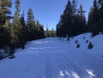
If you live, work, or play in the mountains here in Shasta, it is no surprise that triggering an avalanche is unlikely right now. Snow coverage is sparse. Mount Shasta continues to hold the most useable snowpack, while all other areas have limited coverage or are snow free. We have a good chance for a small storm mid week that could spice up the travel conditions in higher elevation terrain and bring a return to winter.
Recent Observations
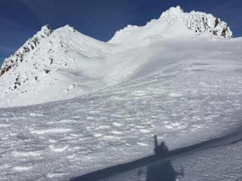
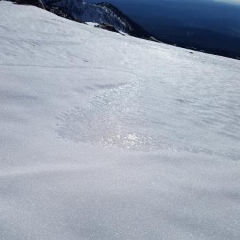
Blustery conditions prevailed yesterday throughout the area, and a ferocious lenticular cloud consumed the upper mountain for the entire day. A shift to north/northwest winds brought the cold air back again. Little change in our snowpack has occurred this month, and a very shallow, consolidated, and strong snowpack continues to exist in terrain 7,000ft and higher on Mount Shasta. Snow surfaces remained rock hard and icy throughout the day yesterday. No avalanches or signs of unstable snow have been observed or reported in over two weeks.
Weather and Current Conditions
Weather Summary
A persistent ridge of high pressure will continue to dominate our weather pattern today and tomorrow. Expect mostly sunny skies throughout the day with highs near 40 degrees at the 6,000ft level. Strong northwest winds will blow, with gusts to 80 mph above treeline on Mount Shasta. A long awaited low-pressure system looks to move through the region Tuesday night and Wednesday. For the first time in over two weeks, we will likely see precipitation throughout the advisory area. The bulk of forecasted snow looks to fall to north of us, but we can expect cold temperatures, low freezing levels, and a modest dose of precipitation.
------------------------------------------------------------------
THIS SEASON PRECIPITATION for MT SHASTA CITY: Since October 1st (the wet season), we have received 5.72 inches of water, normal is 11.20 inches, putting us at 51% of normal. For the month of December, we have received .18 inches of water, normal is 3.84 inches, which is 5% of normal. And finally for the year of 2017, we received 44.71 inches of water, normal is 39.20 inches, putting us at 114% of normal.
Always check the weather before you attempt to climb Mt Shasta. Further, monitor the weather as you climb. Becoming caught on the mountain in any type of weather can compromise life and limb. Be prepared.
24 Hour Weather Station Data @ 0500
| Weather Station | Temp (°F) | Wind (mi/hr) | Snow (in) | Comments | ||||||||
|---|---|---|---|---|---|---|---|---|---|---|---|---|
| Cur | Min | Max | Avg | Avg | Max Gust | Dir | Depth | New | Water Equivalent | Settlement | ||
| Mt. Shasta City (3540 ft) | 32 | 30 | 42 | NNE | ||||||||
| Sand Flat (6750 ft) | 24 | 21 | 33 | 26 | 14 | 0 | 0 | 0 | ||||
| Ski Bowl (7600 ft) | 44 | 38 | 44 | 40 | 18 | 0 | 0 | 0 | station down | |||
| Gray Butte (8000 ft) | 41 | 37 | 41 | 39 | 11 | 31 | NW | station down | ||||
| Castle Lake (5870 ft) | station down | |||||||||||
| Mount Eddy (6509 ft) | ||||||||||||
| Ash Creek Bowl (7250 ft) | station down | |||||||||||
| Ash Creek Ridge (7895 ft) | station down |
Two Day Mountain Weather Forecast
Produced in partnership with the Medford NWS
| For 7000 ft to 9000 ft | |||
|---|---|---|---|
|
Sunday (4 a.m. to 10 p.m.) |
Sunday Night (10 p.m. to 4 a.m.) |
Monday (4 a.m. to 10 p.m.) |
|
| Weather | Mostly sunny | Partly cloudy | Mostly Sunny |
| Temperature (°F) | 42 | 33 | 49 |
| Wind (mi/hr) | North 14-20 mph, gusting 30 mph | North 11 mph | North/Northwest 10-14 mph |
| Precipitation SWE / Snowfall (in) | / 0 | / 0 | / 0 |
| For 9000 ft to 11000 ft | |||
| Sunday | Sunday Night | Monday | |
| Weather | Mostly sunny and windy | Partly cloudy and windy | Mostly sunny and windy |
| Temperature (°F) | 30 | 29 | 30 |
| Wind (mi/hr) | North 45-50 mph, gusting 80 mph | Northwest 0 | West/Northwest 28-34 mph, gusting 50 mph |
| Precipitation SWE / Snowfall (in) | / 0 | / 0 | / 0 |

