

You are here
Avalanche Advisory for 2017-12-20 02:50:01
- EXPIRED ON December 21, 2017 @ 2:50 amPublished on December 20, 2017 @ 2:50 am
- Issued by Aaron Beverly - Mount Shasta Avalanche Center
Bottom Line
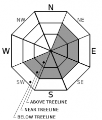
Avalanche danger is MODERATE near and above treeline due to wind slabs forming on leeward aspects greater than 35 degrees. Moderate means human triggered avalanches are possible and natural avalanches are unlikely. If riding in the backcountry today, watch out for rocks hidden below the new snow. Avalanche danger below treeline is LOW.


Avalanche Problem 1: Wind Slab
-
Character ?

-
Aspect/Elevation ?
-
Likelihood ?CertainVery LikelyLikelyPossible
 Unlikely
 -
Size ?HistoricVery LargeLargeSmall

The primary concern today is wind slabs on unsupported slopes greater than 35 degrees with east, southeast, and southern aspects. These slabs could be 8 to 12 inches thick and may exist near and above treeline. Expect continued growth throughout the day with moderate to strong northwest and north winds predicted. With cold temperatures and dry snow, there could be poor bonding at the new / old snow interface. A slab, weak interface, and smooth bed surface create a perfect recipe for an avalanche.
Look for shooting cracks when traveling over safe terrain. This is a sign of the wind slab problem. Stomp on snow drifts to test the snowpack's sensitivity to trigger. Pay attention to wind direction and avoid leeward slopes greater than 35 degrees.
Forecast Discussion
Old Man Winter paid us a visit last night, and for a moment, it felt like winter again. Hopefully you didn't sleep through it! Four inches of snow has spiced life up again and given us a short respite from spring-like weather. Enough snow and wind has combined to raise concern for wind slab avalanches.
In addition to the wind slab problem, small dry loose avalanches are a minor concern on steep slopes. These sloughs are unlikely to be dangerous but could sweep a rider off their feet and into undesirable terrain.
Remember that a few inches of light snow is just enough to cover the multitude of rocks that were exposed in the old snowpack. This may not be the time to ride hard. Tread lightly and save your equipment and knees for another day.
Recent Observations
The cold front that moved in around 6 pm last night brought close to expected amounts of precipitation. The Old Ski Bowl weather station is reporting 4 inches of new snow. West and northwest winds accompanying this precipitation ranged from 20 to 35 mph.
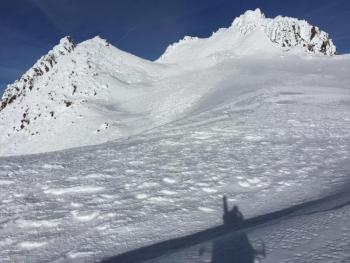
Observations from Monday indicate the existence of a strong consolidated snowpack near and above treeline with surface conditions dominated by melt freeze crusts and wind-eroded snow. The firm melt-freeze surfaces could provide ideal bed surfaces for avalanches. Photos show numerous rocks exposed a few inches above the snowpack. With a few inches of new snow, these rocks could now be covered.
The Castle Lake weather station is reporting trace amounts of new snow. Temperatures dropped below freezing after 5 pm yesterday. Current temperature is 18 degrees F which may contribute to the formation of ice on the lake.
Weather and Current Conditions
Weather Summary
Predicted temperatures and precipitation verified last night as a cold front pushed through the region. Snow levels dropped below 2000 feet. Snow levels will remain low today with little snow expected after 10 am. If ascending above treeline, bring a puffy jacket as wind chills will be below 0 degrees F. Expect a return to warmer dryer weather tomorrow. We may see a slight chance of snow showers on Sunday.
-------------------------
THIS SEASON PRECIPITATION for MT SHASTA CITY: Since October 1st (the wet season), we have received 5.83 inches of water, normal is 12.04 inches, putting us at 48% of normal. For the month of December, we have received .29 inches of water, normal is 4.68 inches, which is 6.2% of normal. And finally for the year of 2017, we received 44.82 inches of water, normal is 40.04 inches, putting us at 112% of normal.
Always check the weather before you attempt to climb Mt Shasta. Further, monitor the weather as you climb. Becoming caught on the mountain in any type of weather can compromise life and limb. Be prepared.
24 Hour Weather Station Data @ 6:00 AM
| Weather Station | Temp (°F) | Wind (mi/hr) | Snow (in) | Comments | ||||||||
|---|---|---|---|---|---|---|---|---|---|---|---|---|
| Cur | Min | Max | Avg | Avg | Max Gust | Dir | Depth | New | Water Equivalent | Settlement | ||
| Mt. Shasta City (3540 ft) | 28 | 27 | 46 | 37 | 3 | N | ||||||
| Sand Flat (6750 ft) | 18 | 17 | 33 | 27 | 15 | 2 | 0 | 0 | ||||
| Ski Bowl (7600 ft) | 14 | 14 | 34 | 22 | 21 | 4 | 0 | 1 | ||||
| Gray Butte (8000 ft) | 12 | 12 | 29 | 20 | 21 | 49 | W | |||||
| Castle Lake (5870 ft) | 19 | 19 | 36 | 28 | 9 | 3 | 4 | |||||
| Mount Eddy (6509 ft) | 17 | 17 | 38 | 25 | 2 | 13 | SE | 8 | 1 | 2 | ||
| Ash Creek Bowl (7250 ft) | Station Down | |||||||||||
| Ash Creek Ridge (7895 ft) | Station Down |
Two Day Mountain Weather Forecast
Produced in partnership with the Medford NWS
| For 7000 ft to 9000 ft | |||
|---|---|---|---|
|
Wednesday (4 a.m. to 10 p.m.) |
Wednesday Night (10 p.m. to 4 a.m.) |
Thursday (4 a.m. to 10 p.m.) |
|
| Weather | A 40 percent chance of snow showers, mainly before 10am. Partly sunny. | A 20 percent chance of snow showers before 10pm. Partly cloudy. | Sunny |
| Temperature (°F) | 25 | 18 | 32 |
| Wind (mi/hr) | Northwest 8-12 mph with gusts up to 30 | North 4-8 mph | Northeast 4-8 mph |
| Precipitation SWE / Snowfall (in) | / 1 | / trace | / 0 |
| For 9000 ft to 11000 ft | |||
| Wednesday | Wednesday Night | Thursday | |
| Weather | A 40 percent chance of snow showers, mainly before 4pm. Partly sunny. Wind chill values as low as -24. Windy. | A 20 percent chance of snow showers before 10pm. Partly cloudy. Wind chill values as low as -18. Windy. | Sunny. Wind chill values as low as -13. Windy. |
| Temperature (°F) | 12 | 15 | 26 |
| Wind (mi/hr) | Northwest 28 - 35 mph, gusts up to 80 | North 1 | Northeast/North 33-35 mph, then 18-22, gusts up to 85 |
| Precipitation SWE / Snowfall (in) | / 1 | / trace | / 0 |

